Wisconsin Counties. List Alphabetically (and by Population)

How many counties are there in Wisconsin? As of 2024, there are a total of 72 counties in the state of Wisconsin. Among them, Brown County is the oldest one (established in 1818) while Menominee County is the youngest (established in 1959).  With population of 947,735, Milwaukee County is the most populated. The biggest county by land area is Marathon County (4,001 km²) and the smallest is Pepin County (601 km²).

Largest Counties in Wisconsin

1. Marathon County

County Overview

  • County Seat: Wausau
  • Area: 1,576 square miles
  • Population: 135,603 (2020 Census)
  • Area Codes: 715, 534
  • Latitude: 44.9630° N
  • Longitude: 89.6202° W

Location and History

Marathon County is located in central Wisconsin and is the largest county in the state by area. The county was established in 1850 and named after the town of Marathon in New York. Wausau, the county seat, developed rapidly in the late 19th century due to the booming timber industry, which utilized the Wisconsin River for transporting logs. As the forests were cleared, the county transitioned to agriculture, particularly dairy farming, which remains a vital part of the local economy. Marathon County’s diverse geography, including forests, rivers, and farmlands, has shaped its development and made it a key economic and cultural hub in Wisconsin.

Major Highways and Landmarks

Interstate 39 and U.S. Route 51 are the major highways that run through Marathon County, connecting it to Madison and the Upper Peninsula of Michigan. The county is also served by State Route 29, which runs east-west, linking Green Bay to the Twin Cities. Major landmarks include Rib Mountain State Park, home to one of the oldest geological formations on earth and Granite Peak Ski Area, one of the largest ski resorts in the Midwest. The Leigh Yawkey Woodson Art Museum in Wausau is renowned for its annual “Birds in Art” exhibition, attracting visitors from around the world. Additionally, the Wisconsin River offers numerous recreational opportunities, including fishing, boating, and hiking along its scenic banks.

2. Vilas County

County Overview

  • County Seat: Eagle River
  • Area: 1,018 square miles
  • Population: 22,195 (2020 Census)
  • Area Codes: 715, 534
  • Latitude: 46.0161° N
  • Longitude: 89.2655° W

Location and History

Vilas County, located in northern Wisconsin, is known for its pristine lakes, forests, and recreational opportunities. The county was established in 1893 and named after William Freeman Vilas, a U.S. Senator from Wisconsin. Eagle River, the county seat, is a popular destination for fishing, boating, and snowmobiling, earning the title “Snowmobile Capital of the World.” The county’s history is deeply connected to the logging industry, which was the primary economic activity in the late 19th and early 20th centuries. As the forests were harvested, tourism began to grow, and today, Vilas County is a major destination for outdoor enthusiasts.

Major Highways and Landmarks

U.S. Route 45 and State Route 70 are the primary highways that provide access to Vilas County, connecting it to other parts of Wisconsin and Michigan’s Upper Peninsula. Major landmarks include the Eagle River Chain of Lakes, the largest inland chain of lakes in the world, offering endless opportunities for boating and fishing. The Northern Highland-American Legion State Forest, which covers a significant portion of the county, is a popular destination for camping, hiking, and wildlife observation. Additionally, the county hosts the annual World Championship Snowmobile Derby, attracting competitors and spectators from around the globe.

3. Forest County

County Overview

  • County Seat: Crandon
  • Area: 1,014 square miles
  • Population: 9,179 (2020 Census)
  • Area Codes: 715, 534
  • Latitude: 45.5735° N
  • Longitude: 88.8853° W

Location and History

Forest County is located in northeastern Wisconsin and is known for its vast tracts of public forestland. The county was established in 1885 and named for the extensive forests that once covered the region. Crandon, the county seat, developed as a logging town in the late 19th century, with the timber industry playing a central role in the county’s early economy. Over time, as the forests were harvested, the county’s economy shifted towards tourism and outdoor recreation, with its numerous lakes, rivers, and forests attracting visitors year-round. The county is also home to the Forest County Potawatomi Community, which has a significant presence in the region.

Major Highways and Landmarks

U.S. Route 8 and State Route 32 are the main highways serving Forest County, providing connections to nearby cities and natural attractions. Major landmarks include the Chequamegon-Nicolet National Forest, which covers a large portion of the county and offers a wide range of recreational activities, including hiking, fishing, and camping. The county is also home to the Crandon International Off-Road Raceway, a major venue for off-road racing events. Additionally, Lake Metonga, located near Crandon, is a popular destination for fishing, boating, and swimming, with its clear waters and scenic surroundings.

4. One

ida County

County Overview

  • County Seat: Rhinelander
  • Area: 1,123 square miles
  • Population: 37,845 (2020 Census)
  • Area Codes: 715, 534
  • Latitude: 45.9038° N
  • Longitude: 89.4334° W

Location and History

Oneida County, located in northern Wisconsin, is renowned for its dense forests, clear lakes, and outdoor recreational opportunities. The county was established in 1887 and named after the Oneida tribe, one of the original inhabitants of the region. Rhinelander, the county seat, developed as a logging center in the late 19th century, with the timber industry driving its early growth. As the logging industry declined, the county transitioned to tourism, with its many lakes and forests becoming popular destinations for vacationers. Today, Oneida County remains a key part of Wisconsin’s Northwoods region, offering a mix of natural beauty and small-town charm.

Major Highways and Landmarks

U.S. Route 8 and U.S. Route 45 are the major highways that traverse Oneida County, providing connections to other parts of Wisconsin and Michigan’s Upper Peninsula. Major landmarks include the Nicolet National Forest, which offers extensive trails for hiking, snowmobiling, and cross-country skiing. The county is also home to the Hodag Country Festival, an annual country music event that attracts visitors from across the Midwest. Additionally, Rhinelander is famous for the legend of the Hodag, a mythical creature that has become a symbol of the city, celebrated with statues, festivals, and local lore.

5. Douglas County

County Overview

  • County Seat: Superior
  • Area: 1,480 square miles
  • Population: 44,295 (2020 Census)
  • Area Codes: 715, 534
  • Latitude: 46.3647° N
  • Longitude: 91.1660° W

Location and History

Douglas County is located in the far northwestern corner of Wisconsin, along the shores of Lake Superior. The county was established in 1854 and named after Stephen A. Douglas, a U.S. Senator from Illinois. Superior, the county seat, developed as a major port city in the late 19th century, serving as a key hub for shipping, particularly for grain and coal. The county’s history is closely tied to the development of the Great Lakes shipping industry, with the Port of Superior playing a central role in the region’s economy. Over time, the county’s economy has diversified to include manufacturing, tourism, and education.

Major Highways and Landmarks

U.S. Route 2 and U.S. Route 53 are the primary highways that run through Douglas County, providing vital links to Minnesota and other parts of Wisconsin. Major landmarks include Pattison State Park, home to Wisconsin’s highest waterfall, Big Manitou Falls, and one of the state’s most scenic natural areas. The county is also home to the Richard I. Bong Veterans Historical Center, a museum dedicated to the memory of America’s highest-scoring WWII fighter ace, Major Richard Bong. Additionally, the Superior Entry Lighthouse, located at the entrance to the Duluth-Superior Harbor, is a historic landmark that offers stunning views of Lake Superior.

6. Polk County

County Overview

  • County Seat: Balsam Lake
  • Area: 956 square miles
  • Population: 44,977 (2020 Census)
  • Area Codes: 715, 534
  • Latitude: 45.4772° N
  • Longitude: 92.3641° W

Location and History

Polk County, located in northwestern Wisconsin, is known for its picturesque landscapes, including rolling hills, lakes, and rivers. The county was established in 1853 and named after James K. Polk, the 11th President of the United States. Balsam Lake, the county seat, developed as a small farming and logging community in the 19th century, with agriculture and timber forming the backbone of the local economy. Over time, the county has become a popular destination for outdoor recreation, with its many lakes and forests drawing visitors for fishing, boating, and hiking. Today, Polk County combines rural charm with natural beauty, making it a vibrant part of Wisconsin’s countryside.

Major Highways and Landmarks

U.S. Route 8 and State Route 35 are the major highways that traverse Polk County, connecting it to the Twin Cities and other parts of Wisconsin. Major landmarks include Interstate State Park, Wisconsin’s oldest state park, located along the scenic St. Croix River, which forms the border between Wisconsin and Minnesota. The park is known for its dramatic glacial potholes, rock formations, and hiking trails. The county is also home to the Trollhaugen Ski Resort, a popular winter destination for skiing, snowboarding, and tubing. Additionally, the St. Croix National Scenic Riverway offers opportunities for canoeing, fishing, and wildlife observation along one of the Midwest’s most pristine rivers.

7. Sawyer County

County Overview

  • County Seat: Hayward
  • Area: 1,350 square miles
  • Population: 18,074 (2020 Census)
  • Area Codes: 715, 534
  • Latitude: 45.9423° N
  • Longitude: 91.1308° W

Location and History

Sawyer County, located in northwestern Wisconsin, is known for its abundant natural resources and outdoor recreation opportunities. The county was established in 1883 and named after Philetus Sawyer, a U.S. Senator from Wisconsin. Hayward, the county seat, developed as a logging town in the late 19th century, with the timber industry dominating the local economy. As the logging industry declined, tourism began to take its place, with the county’s many lakes, forests, and rivers attracting visitors for fishing, hunting, and water sports. Today, Sawyer County is a popular destination for both summer and winter outdoor activities, offering a mix of natural beauty and small-town charm.

Major Highways and Landmarks

U.S. Route 63 and State Route 27 are the primary highways that serve Sawyer County, providing access to other parts of Wisconsin and neighboring states. Major landmarks include the Chequamegon National Forest, which covers a large portion of the county and offers extensive opportunities for hiking, camping, and snowmobiling. The county is also home to the American Birkebeiner Ski Race, the largest cross-country ski race in North America, held annually in Hayward. Additionally, the National Fresh Water Fishing Hall of Fame, located in Hayward, is a major tourist attraction, featuring a giant fiberglass muskie and exhibits on the history of freshwater fishing.

8. Iron County

County Overview

  • County Seat: Hurley
  • Area: 918 square miles
  • Population: 5,687 (2020 Census)
  • Area Codes: 715, 534
  • Latitude: 46.3085° N
  • Longitude: 90.1895° W

Location and History

Iron County is located in northern Wisconsin, along the border with Michigan’s Upper Peninsula. The county was established in 1893 and named for the rich iron ore deposits that were discovered in the region in the late 19th century. Hurley, the county seat, developed as a mining town, with iron mining becoming the dominant industry in the county. The history of Iron County is closely tied to the mining boom that brought settlers to the area, many of whom were immigrants from Italy, Finland, and other European countries. Although the mining industry has declined, the county’s natural beauty and outdoor recreation opportunities have helped to sustain its economy.

Major Highways and Landmarks

U.S. Route 2 and State Route 77 are the major highways that run through Iron County, providing connections to other parts of Wisconsin and Michigan’s Upper Peninsula. Major landmarks include the Turtle-Flambeau Flowage, a vast reservoir that offers some of the best fishing and boating in northern Wisconsin. The county is also home to the Gile Flowage, another popular spot for fishing, camping, and wildlife observation. Additionally, Iron County boasts several scenic waterfalls, including Potato River Falls and Saxon Falls, which are major attractions for hikers and photographers. The Iron County Historical Museum in Hurley preserves the county’s rich mining history and cultural heritage.

9. Burnett County

County Overview

  • County Seat: Siren
  • Area: 880 square miles
  • Population: 15,414 (2020 Census)
  • Area Codes: 715, 534
  • Latitude: 45.7781° N
  • Longitude: 92.3615° W

Location and History

Burnett County, located in northwestern Wisconsin, is characterized by its lakes, rivers, and forests, making it a popular destination for outdoor enthusiasts. The county was established in 1865 and named after Thomas P. Burnett, a Wisconsin politician and territorial legislator. Siren, the county seat, developed as a small logging and farming community in the late 19th century. Over time, the county’s economy has shifted towards tourism, with its many natural attractions drawing visitors for fishing, boating, hunting, and snowmobiling. Burnett County is known for its rural charm, scenic beauty, and strong community spirit.

Major Highways and Landmarks

U.S. Route 63 and State Route 35 are the primary highways that provide access to Burnett County, connecting it to the Twin Cities and other parts of Wisconsin. Major landmarks include Crex Meadows Wildlife Area, one of the largest wildlife areas in the state, offering extensive opportunities for birdwatching, hiking, and nature photography. The county is also home to Governor Knowles State Forest, which stretches along the St. Croix River and provides trails for hiking, horseback riding, and cross-country skiing. Additionally, the county hosts several annual events, including the Siren St. Patrick’s Day Parade and the Webster Rodeo, which attract visitors from across the region.

10. Langlade County

County Overview

  • County Seat: Antigo
  • Area: 888 square miles
  • Population: 19,491 (2020 Census)
  • Area Codes: 715, 534
  • Latitude: 45.1420° N
  • Longitude: 89.1580° W

Location and History

Langlade County, located in northeastern Wisconsin, is known for its rolling hills, forests, and agricultural lands. The county was established in 1879 and named after Charles de Langlade, a French-Canadian fur trader and military officer who played a key role in the region’s early history. Antigo, the county seat, developed as a hub for the logging and potato farming industries, with the fertile soils of the Antigo Flats being particularly well-suited for potato cultivation. Over time, the county’s economy diversified to include dairy farming, manufacturing, and tourism. Today, Langlade County is a blend of agricultural heritage and natural beauty, offering a variety of recreational opportunities.

Major Highways and Landmarks

U.S. Route 45 and State Route 64 are the major highways that serve Langlade County, providing access to other parts of Wisconsin and Michigan’s Upper Peninsula. Major landmarks include the Kettlebowl Ski Area, a small but popular ski destination operated by local volunteers. The county is also home to the Wolf River, a renowned spot for whitewater rafting, kayaking, and fishing, attracting outdoor enthusiasts from across the Midwest. Additionally, the Langlade County Historical Society Museum in Antigo preserves the county’s history, with exhibits on logging, agriculture, and the lives of early settlers. The county’s numerous lakes and forests offer ample opportunities for hunting, fishing, and camping, making it a favorite destination for nature lovers.

List of All Counties in Wisconsin Alphabetically

Below please see all Wisconsin counties which are listed in alphabetical order.

  1. Adams County, WI
  2. Ashland County, WI
  3. Barron County, WI
  4. Bayfield County, WI
  5. Brown County, WI
  6. Buffalo County, WI
  7. Burnett County, WI
  8. Calumet County, WI
  9. Chippewa County, WI
  10. Clark County, WI
  11. Columbia County, WI
  12. Crawford County, WI
  13. Dane County, WI
  14. Dodge County, WI
  15. Door County, WI
  16. Douglas County, WI
  17. Dunn County, WI
  18. Eau Claire County, WI
  19. Florence County, WI
  20. Fond du Lac County, WI
  21. Forest County, WI
  22. Grant County, WI
  23. Green County, WI
  24. Green Lake County, WI
  25. Iowa County, WI
  26. Iron County, WI
  27. Jackson County, WI
  28. Jefferson County, WI
  29. Juneau County, WI
  30. Kenosha County, WI
  31. Kewaunee County, WI
  32. La Crosse County, WI
  33. Lafayette County, WI
  34. Langlade County, WI
  35. Lincoln County, WI
  36. Manitowoc County, WI
  37. Marathon County, WI
  38. Marinette County, WI
  39. Marquette County, WI
  40. Menominee County, WI
  41. Milwaukee County, WI
  42. Monroe County, WI
  43. Oconto County, WI
  44. Oneida County, WI
  45. Outagamie County, WI
  46. Ozaukee County, WI
  47. Pepin County, WI
  48. Pierce County, WI
  49. Polk County, WI
  50. Portage County, WI
  51. Price County, WI
  52. Racine County, WI
  53. Richland County, WI
  54. Rock County, WI
  55. Rusk County, WI
  56. Saint Croix County, WI
  57. Sauk County, WI
  58. Sawyer County, WI
  59. Shawano County, WI
  60. Sheboygan County, WI
  61. Taylor County, WI
  62. Trempealeau County, WI
  63. Vernon County, WI
  64. Vilas County, WI
  65. Walworth County, WI
  66. Washburn County, WI
  67. Washington County, WI
  68. Waukesha County, WI
  69. Waupaca County, WI
  70. Waushara County, WI
  71. Winnebago County, WI
  72. Wood County, WI

Map of Wisconsin Counties
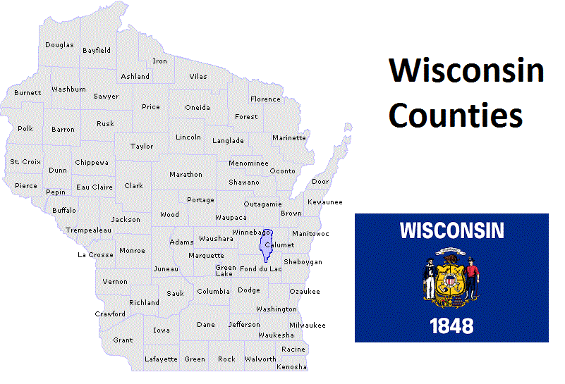
Map of Wisconsin Counties