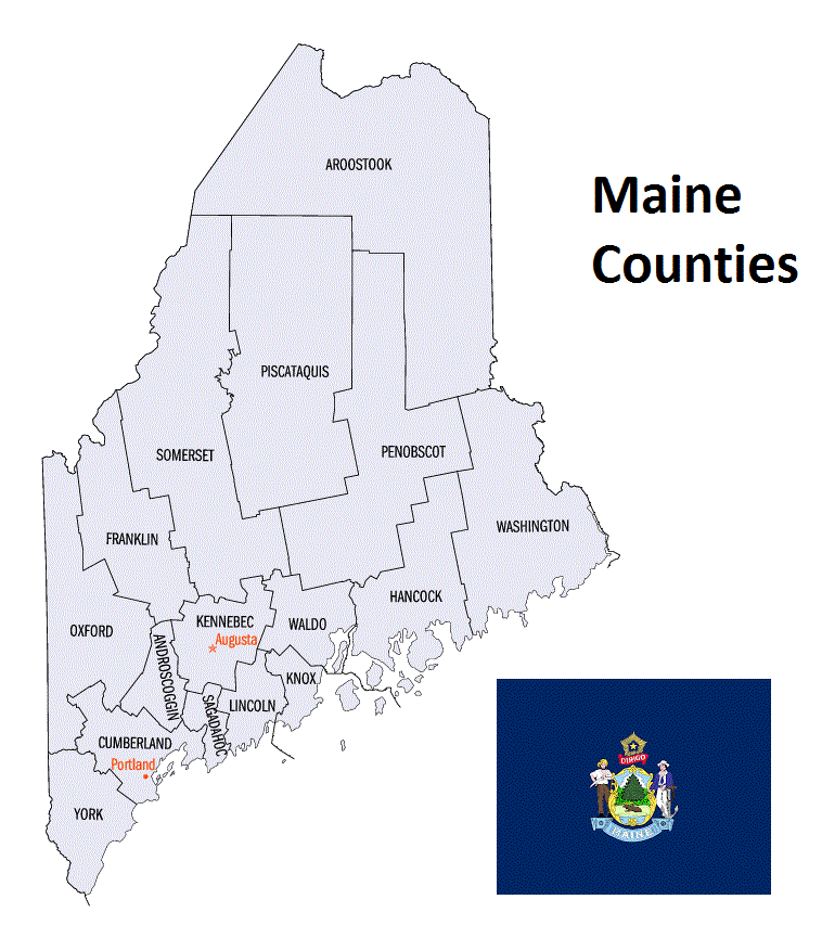
Maine Counties List
There are a total of 16 counties in the state of Maine. Among them, York County is the oldest one (established in 1652) while Knox County is the youngest (established in 1860). With population of 289,977, Cumberland County is the most populated. The biggest county by land area is Aroostook County (17,687 km²) and the smallest is Sagadahoc County (958 km²).
Largest Counties in Maine
1. Aroostook County
County Seat: Houlton
- Area: 6,829 square miles
- Population: Approximately 67,055 (2020 census)
- Area Codes: 207
- Latitude: 46.1266° N
- Longitude: 67.8393° W
Location and History
Aroostook County, the largest county by area in Maine and east of the Mississippi River, is located in the northernmost part of the state, bordering Canada. Established in 1839, the county’s name is derived from a Native American word meaning “beautiful river.” Aroostook is known for its vast forests, agricultural lands, and as a center of potato farming. The county’s history is marked by the Aroostook War, a border dispute between the United States and the United Kingdom in the early 19th century. The county’s economy has traditionally been based on agriculture, particularly potatoes, and forestry, although it has diversified in recent years.
Major Highways and Landmarks
Aroostook County is served by U.S. Route 1, which runs north-south through the county, connecting it to the rest of Maine and Canada. U.S. Route 2 and State Route 11 also provide important regional connections. Key landmarks include the Aroostook State Park, Maine’s first state park, which offers hiking, camping, and scenic views of the surrounding landscape. The county is also home to the Maine Solar System Model, the largest 3D scale model of the solar system in the world, stretching along U.S. Route 1 from Presque Isle to Houlton. The Northern Maine Fair, held annually in Presque Isle, celebrates the region’s agricultural heritage with exhibits, competitions, and entertainment.
2. Penobscot County
County Seat: Bangor
- Area: 3,556 square miles
- Population: Approximately 152,199 (2020 census)
- Area Codes: 207
- Latitude: 44.8012° N
- Longitude: 68.7783° W
Location and History
Penobscot County is located in the central part of Maine, with Bangor serving as its county seat. Established in 1816, the county was named after the Penobscot River, which runs through the region. Bangor, one of the largest cities in Maine, developed as a major lumber port in the 19th century, earning the nickname “The Lumber Capital of the World.” The county’s economy has since diversified, with healthcare, education, and retail playing significant roles. Penobscot County is also known for its cultural and historical significance, with Bangor being the home of author Stephen King.
Major Highways and Landmarks
Penobscot County is intersected by Interstate 95, which runs north-south through the county, connecting it to southern Maine and Canada. U.S. Route 2 and U.S. Route 1A also serve the region. Key landmarks include the Penobscot River, which is central to the county’s history and economy, and the Bangor Waterfront, a popular area for events and recreation along the river. The county is also home to the Cole Land Transportation Museum in Bangor, which showcases the history of transportation in Maine. The Bangor State Fair, one of the oldest fairs in the state, features agricultural exhibits, rides, and entertainment, celebrating the county’s rural heritage.
3. Washington County
County Seat: Machias
- Area: 3,258 square miles
- Population: Approximately 31,095 (2020 census)
- Area Codes: 207
- Latitude: 44.7153° N
- Longitude: 67.4617° W
Location and History
Washington County, known as “Sunrise County” for its easternmost location in the U.S., is located along the coast of Maine, bordering Canada. Established in 1789, the county was named in honor of George Washington. Machias, the county seat, is historically significant as the site of the first naval battle of the American Revolution. The county’s economy has traditionally been based on fishing, especially lobstering, and forestry, with blueberries being a major agricultural product. Washington County is known for its rugged coastline, small fishing villages, and rich maritime heritage.
Major Highways and Landmarks
Washington County is served by U.S. Route 1, which runs along the coast and connects the county to the rest of Maine. State Routes 9 and 192 also provide important regional connections. Key landmarks include the Roosevelt Campobello International Park, located on Campobello Island, which was the summer home of President Franklin D. Roosevelt and is now a symbol of U.S.-Canada relations. The county is also home to the West Quoddy Head Light in Lubec, the easternmost point in the contiguous United States, offering stunning views of the Atlantic Ocean. The annual Machias Blueberry Festival celebrates the county’s blueberry industry with parades, music, and food.
4. Somerset County
County Seat: Skowhegan
- Area: 4,095 square miles
- Population: Approximately 50,477 (2020 census)
- Area Codes: 207
- Latitude: 44.7720° N
- Longitude: 69.7195° W
Location and History
Somerset County is located in the western part of Maine, bordering Quebec, Canada. Established in 1809, the county was named after Somerset, Massachusetts, from which many of the early settlers came. Skowhegan, the county seat, has a rich history tied to the lumber industry and is known for its historic downtown and the Skowhegan State Fair, one of the oldest agricultural fairs in the United States. The county’s economy is based on agriculture, forestry, and tourism, with the region’s natural beauty attracting visitors year-round.
Major Highways and Landmarks
Somerset County is accessible via U.S. Route 201, which runs north-south through the county, connecting it to Quebec and other parts of Maine. State Routes 16 and 150 also serve the region. Significant landmarks include the Forks, a popular destination for whitewater rafting on the Kennebec River, and the Bigelow Mountain Range, part of the Appalachian Trail, which offers hiking and stunning views. The Skowhegan State Fair, held annually since 1818, features agricultural exhibits, competitions, and entertainment, celebrating the county’s rural heritage. The Lakewood Theater in Madison, one of the oldest summer theaters in the U.S., is another cultural landmark in the county.
5. Piscataquis County
County Seat: Dover-Foxcroft
- Area: 3,961 square miles
- Population: Approximately 16,800 (2020 census)
- Area Codes: 207
- Latitude: 45.1835° N
- Longitude: 69.2221° W
Location and History
Piscataquis County is located in central Maine, known for its vast wilderness and outdoor recreation opportunities. Established in 1838, the county’s name is derived from an Abenaki word meaning “branch of the river.” Dover-Foxcroft, the county seat, is a small community with a history rooted in agriculture and manufacturing. The county is one of the least populated in Maine, making it a haven for outdoor enthusiasts seeking solitude and natural beauty. The region’s economy is based on forestry, tourism, and small-scale agriculture.
Major Highways and Landmarks
Piscataquis County is served by State Routes 6, 11, and 15, which provide access to the region’s remote areas. Key landmarks include Moosehead Lake, the largest lake in Maine, which offers boating, fishing, and hiking opportunities, and is a gateway to the state’s North Woods. The county is also home to Mount Katahdin, the highest peak in Maine and the northern terminus of the Appalachian Trail. The 100-Mile Wilderness, a remote section of the Appalachian Trail, is located in Piscataquis County and is considered one of the most challenging and scenic parts of the trail. The annual Dover-Foxcroft Homecoming, with its parades and community events, highlights the county’s close-knit community spirit.
6. Hancock County
County Seat: Ellsworth
- Area: 2,351 square miles
- Population: Approximately 55,478 (2020 census)
- Area Codes: 207
- Latitude: 44.5425° N
- Longitude: 68.4192° W
Location and History
Hancock County is located along the coast of Maine, encompassing part of Mount Desert Island and the Acadia National Park. Established in 1789, the county was named after John Hancock, a prominent figure in the American Revolution. Ellsworth, the county seat, developed as a center for shipbuilding and trade in the 19th century and is now a hub for tourism and retail. Hancock County is known for its stunning coastal landscapes, historic towns, and as the gateway to Acadia National Park, one of the most visited national parks in the United States.
Major Highways and Landmarks
Hancock County is intersected by U.S. Route 1, which runs along the coast, and State Route 3, which provides access to Mount Desert Island and Acadia National Park. Key landmarks include Acadia National Park, which offers breathtaking scenery, hiking trails, and opportunities for wildlife observation. The park’s Cadillac Mountain is the highest point on the U.S. East Coast and is known for its spectacular sunrise views. The county is also home to Bar Harbor, a popular tourist destination known for its shops, restaurants, and access to outdoor activities. The Blue Hill Peninsula, with its charming villages and art galleries, is another highlight of Hancock County.
7. Oxford County
County Seat: Paris
- Area: 2,176 square miles
- Population: Approximately 57,777 (2020 census)
- Area Codes: 207
- Latitude: 44.2590° N
- Longitude: 70.4530° W
Location and History
Oxford County is located in western Maine, bordering New Hampshire. Established in 1805, the county was named after Oxford, Massachusetts. Paris, the county seat, is known for its historic architecture and as the birthplace of Hannibal Hamlin, the 15th Vice President of the United States. Oxford County’s economy has traditionally been based on agriculture, forestry, and manufacturing, with tourism playing an increasingly important role due to the region’s mountains, lakes, and ski resorts.
Major Highways and Landmarks
Oxford County is served by U.S. Route 2, which runs east-west through the county, and State Routes 26 and 117. Significant landmarks include the White Mountain National Forest, which extends into Oxford County and offers hiking, skiing, and camping opportunities. The county is also home to Sunday River Ski Resort, one of the largest and most popular ski resorts in New England. The Oxford Casino in the town of Oxford is a major entertainment venue that draws visitors from across the region. The annual Oxford County Fair, held in September, features agricultural exhibits, races, and entertainment, celebrating the county’s rural heritage.
8. Franklin County
County Seat: Farmington
- Area: 1,744 square miles
- Population: Approximately 29,456 (2020 census)
- Area Codes: 207
- Latitude: 44.6733° N
- Longitude: 70.1515° W
Location and History
Franklin County is located in western Maine, bordering Quebec, Canada. Established in 1838, the county was named after Benjamin Franklin. Farmington, the county seat, is a historic town known for its educational institutions, including the University of Maine at Farmington, the state’s first public institution of higher education. The county’s economy has traditionally been based on agriculture, forestry, and small-scale manufacturing, with tourism playing a growing role due to the region’s natural beauty and outdoor recreation opportunities.
Major Highways and Landmarks
Franklin County is accessible via U.S. Route 2, which runs east-west through the county, and State Routes 4 and 27. Key landmarks include the Bigelow Preserve, which offers hiking and stunning views of the Bigelow Mountain Range, and the Rangeley Lakes region, a popular destination for fishing, boating, and skiing. The county is also home to the Sugarloaf Mountain Resort, one of the largest ski areas in the eastern United States. The annual Farmington Fair, held in September, is a highlight of the county’s calendar, featuring agricultural exhibits, competitions, and entertainment that showcase the area’s rural traditions.
9. Waldo County
County Seat: Belfast
- Area: 1,284 square miles
- Population: Approximately 39,607 (2020 census)
- Area Codes: 207
- Latitude: 44.4259° N
- Longitude: 69.0064° W
Location and History
Waldo County is located along the central coast of Maine, with Belfast serving as its county seat. Established in 1827, the county was named after Samuel Waldo, a colonial landowner. Belfast, known for its well-preserved historic district and vibrant arts scene, developed as a major shipbuilding center in the 19th century. The county’s economy has since diversified, with tourism, agriculture, and small-scale manufacturing playing important roles. Waldo County is known for its scenic coastline, rolling hills, and strong community spirit.
Major Highways and Landmarks
Waldo County is served by U.S. Route 1, which runs along the coast, and State Route 3, which provides access to Augusta, the state capital. Significant landmarks include the Penobscot Narrows Bridge and Observatory, which offers panoramic views of the Penobscot River and surrounding area. The county is also home to the historic Searsport town, known for its maritime history and the Penobscot Marine Museum, which preserves the region’s seafaring heritage. The annual Belfast Harbor Fest celebrates the county’s coastal culture with boat races, seafood, and music, drawing visitors from across Maine.
10. York County
County Seat: Alfred
- Area: 1,271 square miles
- Population: Approximately 211,972 (2020 census)
- Area Codes: 207
- Latitude: 43.4742° N
- Longitude: 70.7105° W
Location and History
York County, the oldest county in Maine, is located in the southern part of the state, bordering New Hampshire and the Atlantic Ocean. Established in 1636 when Maine was part of the Massachusetts Bay Colony, the county is named after York, England. Alfred, the county seat, is a small, historic town known for its rural charm. York County’s economy is diverse, with tourism, manufacturing, and healthcare playing significant roles. The county’s coastal towns, such as York and Ogunquit, are popular tourist destinations, known for their beaches, historic sites, and cultural attractions.
Major Highways and Landmarks
York County is intersected by Interstate 95, which runs north-south through the county, connecting it to Boston and Portland. U.S. Routes 1 and 202 also run through the county. Notable landmarks include the Nubble Lighthouse in York, one of the most photographed lighthouses in the United States, and the Rachel Carson National Wildlife Refuge, which protects a variety of coastal habitats. The county is also home to the Ogunquit Playhouse, a historic summer theater that attracts top talent from Broadway. The annual York Harvestfest and Kids Festival is a major event that celebrates the region’s agricultural heritage with crafts, food, and family-friendly activities.
List of All Counties in Maine
Below please see all Maine counties which are listed in alphabetical order.
- Androscoggin County, ME
- Aroostook County, ME
- Cumberland County, ME
- Franklin County, ME
- Hancock County, ME
- Kennebec County, ME
- Knox County, ME
- Lincoln County, ME
- Oxford County, ME
- Penobscot County, ME
- Piscataquis County, ME
- Sagadahoc County, ME
- Somerset County, ME
- Waldo County, ME
- Washington County, ME
- York County, ME