Alaska Counties List

There are a total of 19 counties (boroughs) in the state of Alaska. Among them, Bristol Bay Borough is the oldest one (established in 1962) while Petersburg Borough is the youngest (established in 2013).  With population of 291,826, Anchorage is the most populated. The biggest county by land area is North Slope Borough (230,035 km²) and the smallest is Skagway (1,171 km²).

Largest Counties in Alaska

1. Yukon-Koyukuk Census Area

County Seat: No official seat (Administrative offices in Galena)

  • Area: 145,505 square miles
  • Population: Approximately 5,343 (2020 census)
  • Area Codes: 907
  • Latitude: 64.7361° N
  • Longitude: 156.8967° W

Location and History

The Yukon-Koyukuk Census Area is the largest county-equivalent area in Alaska and the United States, situated in the interior region of the state. It was established as a census area, a term used in Alaska where boroughs or counties do not exist in the same way as in the contiguous U.S. The area encompasses vast wilderness, including large portions of the Yukon River, the Koyukuk River, and their tributaries. Its history is deeply tied to the indigenous Athabascan people who have inhabited the region for thousands of years. The area saw increased activity during the Klondike Gold Rush in the late 19th century, although its remote location has kept it sparsely populated.

Major Highways and Landmarks

Due to its remote and vast terrain, the Yukon-Koyukuk Census Area has no major highways. Instead, transportation is primarily via riverboats, bush planes, and snowmobiles. Major landmarks include the Gates of the Arctic National Park and Preserve, one of the most remote and pristine wilderness areas in the U.S., and the Yukon-Charley Rivers National Preserve, which protects the natural and cultural heritage along the Yukon River. The area also includes the village of Fort Yukon, known for its historical trading post established by the Hudson’s Bay Company.

2. North Slope Borough

County Seat: Utqiaġvik (formerly Barrow)

  • Area: 94,763 square miles
  • Population: Approximately 11,031 (2020 census)
  • Area Codes: 907
  • Latitude: 71.2906° N
  • Longitude: 156.7886° W

Location and History

The North Slope Borough is located in the northernmost region of Alaska, extending from the Brooks Range to the Arctic Ocean. It was established in 1972 as a borough, a form of regional government unique to Alaska. The area is home to the Inupiat people, who have lived in the harsh Arctic environment for centuries. The discovery of vast oil reserves at Prudhoe Bay in 1968 transformed the region, leading to the construction of the Trans-Alaska Pipeline and significantly impacting the local economy and environment. Utqiaġvik, the borough seat, is the northernmost city in the United States.

Major Highways and Landmarks

The North Slope Borough is connected by the Dalton Highway, also known as the “Haul Road,” which extends from Fairbanks to the oil fields at Prudhoe Bay. Key landmarks include the Arctic National Wildlife Refuge, which is one of the largest and most ecologically significant protected areas in the U.S., and the Iñupiat Heritage Center in Utqiaġvik, which preserves the cultural history of the Inupiat people. The region is also known for its dramatic landscapes, including the Brooks Range, and for being a prime location for viewing polar bears and the Northern Lights.

3. Bethel Census Area

County Seat: Bethel

  • Area: 45,504 square miles
  • Population: Approximately 18,666 (2020 census)
  • Area Codes: 907
  • Latitude: 60.7922° N
  • Longitude: 161.7558° W

Location and History

The Bethel Census Area is located in southwestern Alaska, encompassing a vast expanse of tundra, rivers, and wetlands. It was formed as part of the Unorganized Borough, meaning it has no borough government and is administered directly by the state. The area is primarily inhabited by the Yup’ik people, whose ancestors have lived in the region for thousands of years. Bethel, the largest community, serves as the hub for the Yukon-Kuskokwim Delta, an area rich in wildlife and known for its subsistence lifestyle. The region’s history is closely tied to its indigenous culture and the fur trade.

Major Highways and Landmarks

There are no major highways in the Bethel Census Area; transportation is predominantly by air and river. The Kuskokwim River, one of the longest rivers in Alaska, serves as a vital transportation route. Significant landmarks include the Yukon Delta National Wildlife Refuge, which covers much of the region and is one of the largest refuges in the U.S., supporting a vast array of migratory birds and other wildlife. Bethel itself is home to the annual Kuskokwim 300, one of the most challenging dog sled races in Alaska. The area’s remote villages and rich cultural traditions make it unique in the state.

4. Yukon–Kuskokwim Delta Census Area

County Seat: No official seat (Administrative offices in Bethel)

  • Area: 39,998 square miles
  • Population: Approximately 21,300 (2020 census)
  • Area Codes: 907
  • Latitude: 61.9355° N
  • Longitude: 162.8997° W

Location and History

The Yukon–Kuskokwim Delta Census Area is located in southwestern Alaska and is known for its sprawling delta formed by the confluence of the Yukon and Kuskokwim Rivers. The area has been inhabited by the Yup’ik people for millennia, and it remains one of the most culturally intact regions in Alaska. The census area was established as part of the Unorganized Borough, meaning it has no borough government. The delta is one of the most important subsistence hunting and fishing areas in Alaska, with the local economy heavily reliant on traditional practices.

Major Highways and Landmarks

As with many remote areas of Alaska, the Yukon–Kuskokwim Delta Census Area lacks major highways, relying instead on river transportation and air travel. The Yukon Delta National Wildlife Refuge, which spans the region, is a major landmark, known for its critical habitat for migratory birds and other wildlife. The area is also home to numerous small, traditional villages, where subsistence activities such as fishing, hunting, and gathering remain central to daily life. The expansive and pristine wetlands of the delta are a crucial ecological zone, supporting a diverse range of species and providing a unique environment in the Arctic.

5. Southeast Fairbanks Census Area

County Seat: No official seat (Administrative offices in Tok)

  • Area: 25,061 square miles
  • Population: Approximately 6,808 (2020 census)
  • Area Codes: 907
  • Latitude: 63.3290° N
  • Longitude: 142.9853° W

Location and History

The Southeast Fairbanks Census Area is located in eastern Alaska, bordering Canada’s Yukon Territory. The area was originally inhabited by the Athabascan people and later became a key route during the Klondike Gold Rush, with many travelers passing through on their way to the gold fields. The area remains sparsely populated, with a mix of small communities that rely on subsistence activities, mining, and government services. Tok, the largest community, is often referred to as the “Gateway to Alaska” due to its location along the Alaska Highway, the primary route into Alaska from Canada.

Major Highways and Landmarks

The Southeast Fairbanks Census Area is traversed by the Alaska Highway, a critical overland route connecting the state to the contiguous United States via Canada. The Taylor Highway, leading to the historic town of Eagle and the Forty Mile mining district, is another significant route. Key landmarks include the Tetlin National Wildlife Refuge, known for its rich wildlife and beautiful landscapes, and the Wrangell-St. Elias National Park and Preserve, which partially lies within the census area and is the largest national park in the United States. The area is also known for the annual Tok Trot, a popular 10K race held each summer.

6. Northwest Arctic Borough

County Seat: Kotzebue

  • Area: 35,898 square miles
  • Population: Approximately 7,793 (2020 census)
  • Area Codes: 907
  • Latitude: 66.8963° N
  • Longitude: 162.5966° W

Location and History

The Northwest Arctic Borough is located in northwestern Alaska, bordering the Chukchi Sea. Established in 1986, the borough encompasses a region rich in indigenous history, particularly that of the Inupiat people, who have lived in the area for thousands of years. Kotzebue, the borough seat, has long been a center for trade and culture in the Arctic. The discovery of the Red Dog Mine, one of the world’s largest producers of zinc, has had a significant economic impact on the region. Despite modern developments, traditional subsistence activities such as hunting, fishing, and gathering remain integral to the local culture.

Major Highways and Landmarks

The Northwest Arctic Borough is remote, with no major highways. Transportation is typically by air, boat, or snowmobile. Key landmarks include the Cape Krusenstern National Monument, which preserves archaeological sites dating back thousands of years, and the Kobuk Valley National Park, known for its sand dunes and caribou migrations. The Red Dog Mine is a significant industrial landmark, representing one of the largest open-pit mines in the world. The area’s pristine wilderness and rich cultural history make it a unique and vital part of Alaska’s heritage.

7. Kusilvak Census Area

County Seat: No official seat (Administrative offices in Hooper Bay)

  • Area: 19,673 square miles
  • Population: Approximately 8,368 (2020 census)
  • Area Codes: 907
  • Latitude: 62.7432° N
  • Longitude: 164.5149° W

Location and History

The Kusilvak Census Area, formerly known as the Wade Hampton Census Area, is located in western Alaska along the Bering Sea coast. It is part of the Unorganized Borough and has no borough-level government. The area is predominantly inhabited by Yup’ik people, whose ancestors have lived in the region for thousands of years. The name “Kusilvak” comes from a mountain in the area and reflects the local Yup’ik heritage. The region is characterized by its remote villages, subsistence lifestyle, and strong cultural traditions, with much of the population relying on fishing, hunting, and gathering for sustenance.

Major Highways and Landmarks

There are no major highways in the Kusilvak Census Area, and transportation is mainly by air and water. Key landmarks include the Yukon Delta National Wildlife Refuge, which encompasses much of the region and is vital for wildlife conservation, particularly for migratory birds. The Andreafsky Wilderness, part of the refuge, is known for its pristine rivers and natural beauty. The area is also home to traditional Yup’ik villages, where subsistence practices are a way of life. The region’s remoteness and cultural richness make it a distinctive part of Alaska’s landscape.

8. Valdez-Cordova Census Area (now part of Copper River Census Area and Chugach Census Area)

County Seat: Valdez (for Chugach) and Cordova (for Copper River)

  • Area: 34,180 square miles (combined)
  • Population: Approximately 9,639 (2020 census, before reorganization)
  • Area Codes: 907
  • Latitude: 61.1308° N
  • Longitude: 146.3483° W

Location and History

The former Valdez-Cordova Census Area, now reorganized into the Chugach Census Area and Copper River Census Area, was located in southern Alaska. This vast area includes parts of the Chugach and Wrangell-St. Elias mountain ranges and was home to both the Chugach and Ahtna indigenous peoples. Valdez, the northernmost ice-free port in North America, became known for the devastating 1964 earthquake and the 1989 Exxon Valdez oil spill. Cordova, on the other hand, has a rich history linked to fishing, particularly salmon, and has been a key center for commercial fishing in Alaska.

Major Highways and Landmarks

The Richardson Highway, which connects Valdez to Fairbanks, is the main overland route through the region. The area also includes portions of the Alaska Marine Highway, which serves coastal communities. Major landmarks include the Wrangell-St. Elias National Park and Preserve, the largest national park in the United States, and the Prince William Sound, known for its stunning scenery and abundant marine life. The Copper River, famous for its wild salmon, and the historic Kennicott copper mines are other significant landmarks in this region, which is noted for its rugged beauty and historical significance.

9. Nome Census Area

County Seat: Nome

  • Area: 28,278 square miles
  • Population: Approximately 10,046 (2020 census)
  • Area Codes: 907
  • Latitude: 64.5011° N
  • Longitude: 165.4064° W

Location and History

The Nome Census Area is located in western Alaska on the Seward Peninsula, facing the Bering Sea. The area was historically inhabited by the Inupiat people, who continue to have a strong presence in the region. Nome, the largest city in the area, gained fame during the Gold Rush of the early 1900s, when thousands of prospectors flocked to the region in search of fortune. Today, Nome is known as the finish line for the Iditarod Trail Sled Dog Race, which commemorates the historic serum run to Nome in 1925.

Major Highways and Landmarks

There are no major highways in the Nome Census Area; however, a network of local roads connects Nome to nearby communities and historical sites. Significant landmarks include the Bering Land Bridge National Preserve, which preserves the unique geology and cultural history of the area, and the Cape Nome mining district, which still draws small-scale gold miners. The area is also home to the annual Iditarod Sled Dog Race, with the finish line located in Nome. The remote and rugged landscape of the Seward Peninsula is a defining feature of the region.

10. Matanuska-Susitna Borough

County Seat: Palmer

  • Area: 25,258 square miles
  • Population: Approximately 107,081 (2020 census)
  • Area Codes: 907
  • Latitude: 61.5997° N
  • Longitude: 149.1127° W

Location and History

The Matanuska-Susitna Borough, commonly known as Mat-Su, is located in south-central Alaska, just north of Anchorage. The borough was established in 1964 and is one of the fastest-growing regions in the state, driven by its proximity to Anchorage and its appeal as a rural yet accessible area. The region was initially settled during the New Deal era as part of an agricultural project, and agriculture remains important, particularly the growing of vegetables in the fertile Matanuska Valley. The area is also known for its dramatic landscapes, including views of Denali, North America’s highest peak.

Major Highways and Landmarks

The Matanuska-Susitna Borough is served by several major highways, including the Glenn Highway and the Parks Highway, which connect the region to Anchorage, Fairbanks, and other parts of Alaska. Notable landmarks include Denali State Park, offering stunning views of Denali and opportunities for outdoor recreation, and the Hatcher Pass area, known for its hiking, skiing, and the historic Independence Mine. The Alaska State Fair, held annually in Palmer, is a major event that celebrates the region’s agricultural heritage. The borough’s mix of natural beauty, historical sites, and modern amenities make it a vibrant and attractive place to live and visit.

List of All Counties in Alaska

Below please see all Alaska counties which are listed in alphabetical order.

  1. Aleutians East Borough, AK
  2. Anchorage Borough, AK
  3. Bristol Bay Borough, AK
  4. Denali Borough, AK
  5. Fairbanks North Star Borough, AK
  6. Haines Borough, AK
  7. Juneau Borough, AK
  8. Kenai Peninsula Borough, AK
  9. Ketchikan Gateway Borough, AK
  10. Kodiak Island Borough, AK
  11. Lake and Peninsula Borough, AK
  12. Matanuska-Susitna Borough, AK
  13. North Slope Borough, AK
  14. Northwest Arctic Borough, AK
  15. Petersburg Borough, AK
  16. Sitka Borough, AK
  17. Skagway Borough, AK
  18. Wrangell Borough, AK
  19. Yakutat Borough, AK

Map of Alaska Counties
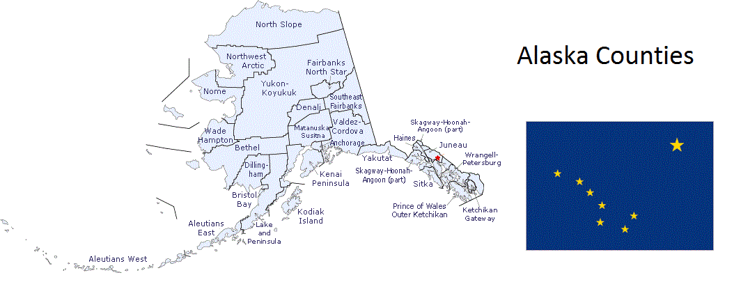
Map of Alaska Counties