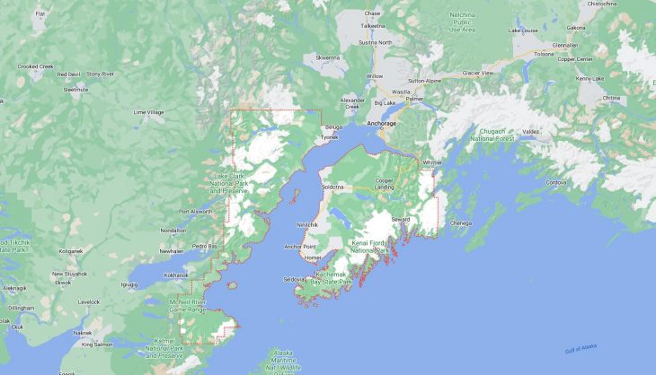
Cities and Towns in Kenai Peninsula Borough, Alaska

Founded in 1964, Kenai Peninsula Borough is one of 20 boroughs in the state of Alaska. The city of Soldotna is the borough seat. With FIPS code of 122, Kenai Peninsula Borough has a population of 59,767 and area of 16,017 square miles (41,484 km²).

List of all cities in Kenai Peninsula Borough, AK alphabetically

City/Town Postal Code Area Code
Anchor Point, AK 99556 907
Clam Gulch, AK 99568 907
Cooper Landing, AK 99572 907
English Bay, AK 99603 907
Fritz Creek, AK 99603 907
Halibut Cove, AK 99603 907
Homer, AK 99603 907
Hope, AK 99605 907
Kasilof, AK 99610 907
Kenai, AK 99611 907
Kenai, AK 99635 907
Moose Pass, AK 99631 907
Nanwalek, AK 99603 907
Nikishka, AK 99635 907
Nikiski, AK 99635 907
Nikolaevsk, AK 99556 907
Ninilchik, AK 99639 907
Port Graham, AK 99603 907
Seldovia, AK 99663 907
Seward, AK 99664 907
Soldotna, AK 99669 907
Sterling, AK 99672 907
Tyonek, AK 99682 907

Major Cities and Towns in Kenai Peninsula Borough, Alaska

Kenai

Area, Population, and Coordinates

  • Area: 35.5 square miles
  • Population: 7,424 (as of the last census)
  • ZIP Codes: 99611
  • Latitude and Longitude:
    • Latitude: 60.5544° N
    • Longitude: 151.2583° W

Location and History

Kenai is one of the oldest communities on the Kenai Peninsula, located on the western coast along the mouth of the Kenai River. The area was originally inhabited by the Dena’ina Athabascan people, and the city was established in 1791 as a Russian fur trading post. Kenai played a significant role in the early Russian exploration and settlement of Alaska, and its history is reflected in the mix of Russian Orthodox and indigenous influences that are still present today. After Alaska was purchased by the United States, Kenai developed into a fishing and canning center, and later, the discovery of oil in nearby Cook Inlet in the 1950s led to rapid growth and economic diversification. Today, Kenai is known for its rich history, vibrant community, and stunning natural surroundings.

Major Schools and Landmarks

Kenai is served by the Kenai Peninsula Borough School District, with Kenai Central High School, Kenai Middle School, and several elementary schools providing education to local students. The city is home to several significant landmarks, including the Kenai Visitor and Cultural Center, which offers exhibits on the region’s history and culture, and the Holy Assumption of the Virgin Mary Russian Orthodox Church, one of the oldest churches in Alaska. The Kenai River is a major attraction, known for its world-class salmon fishing, and the Kenai Beach offers breathtaking views of Cook Inlet and the surrounding mountains. The annual Kenai River Festival celebrates the community’s connection to the river with music, art, and activities that highlight the area’s natural beauty and heritage.

Soldotna

Area, Population, and Coordinates

  • Area: 7.4 square miles
  • Population: 4,163 (as of the last census)
  • ZIP Codes: 99669
  • Latitude and Longitude:
    • Latitude: 60.4872° N
    • Longitude: 151.0583° W

Location and History

Soldotna is centrally located on the Kenai Peninsula, along the banks of the Kenai River. The town was established in the late 1940s, following World War II, when the federal government offered land to veterans. The area’s accessibility and fertile lands quickly attracted settlers, and Soldotna grew into a hub for homesteading and agriculture. The discovery of oil in the nearby Swanson River in 1957 further accelerated Soldotna’s growth, making it an important commercial and administrative center for the region. Today, Soldotna is known for its outdoor recreational opportunities, particularly fishing, with the Kenai River being a focal point for both residents and visitors.

Major Schools and Landmarks

Soldotna is part of the Kenai Peninsula Borough School District, with Soldotna High School, Soldotna Middle School, and several elementary schools serving the community. The town is home to the Kenai Peninsula College, a branch of the University of Alaska Anchorage, which offers higher education opportunities to the region. Notable landmarks in Soldotna include the Soldotna Creek Park, which hosts numerous community events and provides access to the Kenai River, and the Soldotna Historical Society and Museum, which showcases the area’s pioneer history. The nearby Kenai National Wildlife Refuge offers vast wilderness areas for hiking, wildlife viewing, and camping, making Soldotna a gateway to some of Alaska’s most pristine natural environments.

Homer

Area, Population, and Coordinates

  • Area: 22.4 square miles
  • Population: 5,922 (as of the last census)
  • ZIP Codes: 99603
  • Latitude and Longitude:
    • Latitude: 59.6425° N
    • Longitude: 151.5483° W

Location and History

Homer is a picturesque city located at the end of the Sterling Highway on the southern tip of the Kenai Peninsula, known as “the Halibut Fishing Capital of the World.” The area was originally inhabited by Alutiiq and Dena’ina Athabascan peoples. Homer was founded in the late 19th century as a coal mining town, but it soon transitioned to fishing, which has remained a central part of its economy. The city’s stunning natural setting, with views of Kachemak Bay and the surrounding mountains, has also made it a popular destination for artists, outdoor enthusiasts, and tourists. Homer’s cultural scene is vibrant, with a strong focus on the arts, local food, and environmental stewardship.

Major Schools and Landmarks

Homer is served by the Kenai Peninsula Borough School District, with Homer High School, Homer Middle School, and several elementary schools providing education to local students. The city is home to the Homer Campus of Kenai Peninsula College, offering a range of educational programs and community classes. Key landmarks in Homer include the Homer Spit, a long, narrow landform that extends into Kachemak Bay and is home to shops, restaurants, and the Homer Boat Harbor. The Pratt Museum offers exhibits on the natural history, culture, and art of the region, while the Alaska Islands and Ocean Visitor Center focuses on the marine ecosystems of Kachemak Bay. The annual Homer Winter King Salmon Tournament and the Kachemak Bay Shorebird Festival are popular events that draw visitors to the area, showcasing Homer’s rich natural and cultural heritage.

Seward

Area, Population, and Coordinates

  • Area: 21.5 square miles
  • Population: 2,773 (as of the last census)
  • ZIP Codes: 99664
  • Latitude and Longitude:
    • Latitude: 60.1042° N
    • Longitude: 149.4422° W

Location and History

Seward is a historic city located on the eastern coast of the Kenai Peninsula, along the shores of Resurrection Bay. The city was founded in 1903 as the southern terminus of the Alaska Railroad and was named after William H. Seward, the U.S. Secretary of State who negotiated the purchase of Alaska from Russia. Seward quickly became an important port and supply center, serving as a gateway to interior Alaska during the early 20th century. The city’s strategic location made it a hub for transportation and commerce, and it remains an important port for fishing, tourism, and shipping today. Seward is also known for its resilience, having been largely rebuilt after the 1964 Good Friday Earthquake and tsunami.

Major Schools and Landmarks

Seward is part of the Kenai Peninsula Borough School District, with Seward High School, Seward Middle School, and Seward Elementary School serving the community. The town is home to several significant landmarks, including the Alaska SeaLife Center, a marine research and rehabilitation facility that offers interactive exhibits on Alaska’s marine ecosystems. The historic Iditarod Trail, which begins in Seward, is commemorated with the Iditarod National Historic Trail, offering hiking and historical insights into Alaska’s gold rush era. The nearby Kenai Fjords National Park, with its stunning glaciers, fjords, and abundant wildlife, is a major attraction for both residents and tourists. The annual Mount Marathon Race, one of the oldest foot races in North America, is a highlight of Seward’s Fourth of July celebrations, drawing athletes and spectators from around the world.

Map of Cities in Kenai Peninsula Borough, AK

Map of Cities in Kenai Peninsula Borough, AK