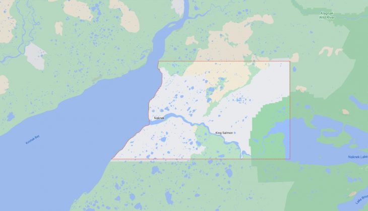
Cities and Towns in Bristol Bay Borough, Alaska
Founded in 1962, Bristol Bay Borough is one of 20 boroughs in the state of Alaska. The city of Naknek is the borough seat. With FIPS code of 60, Bristol Bay Borough has a population of 838 and area of 482 square miles (1,248 km²).
List of all cities in Bristol Bay Borough, AK alphabetically
| City/Town | Postal Code | Area Code |
| Igiugig, AK | 99613 | 907 |
| King Salmon, AK | 99613 | 907 |
| Naknek, AK | 99633 | 907 |
| South Naknek, AK | 99670 | 907 |
Major Cities and Towns in Bristol Bay Borough, Alaska
Naknek
Area, Population, and Coordinates
- Area: 84.6 square miles
- Population: 544 (as of the last census)
- ZIP Codes: 99633
- Latitude and Longitude:
- Latitude: 58.7289° N
- Longitude: 157.0122° W
Location and History
Naknek is a small community located in the Bristol Bay Borough of Alaska, on the northern shore of the Naknek River. This area has been inhabited for thousands of years by indigenous peoples, particularly the Yup’ik Eskimos, who relied on the region’s abundant natural resources. Naknek’s modern history began with the arrival of Russian explorers in the 19th century, followed by the development of the commercial fishing industry in the late 1800s. The town quickly became a hub for salmon fishing, which remains the cornerstone of its economy today. Naknek is known for its seasonal influx of fishermen and cannery workers during the summer months when the salmon runs are at their peak. Despite its remote location, Naknek is a vital center for the Bristol Bay fishing industry, providing services and infrastructure for the region’s lucrative commercial fishing operations.
Major Schools and Landmarks
Naknek is served by the Bristol Bay Borough School District, with Naknek School providing education from kindergarten through 12th grade. The town’s most significant landmarks include the Naknek River, which is central to the local fishing industry and culture. The Alaska Peninsula National Wildlife Refuge, located nearby, offers stunning natural landscapes and opportunities for wildlife viewing, particularly for bears and migratory birds. The King Salmon Airport, situated a short distance from Naknek, is a key transportation hub for the region, connecting the remote community to larger cities like Anchorage. Additionally, the Naknek Cannery History Museum provides insights into the area’s rich fishing heritage and the evolution of the local canning industry.
King Salmon
Area, Population, and Coordinates
- Area: 170.4 square miles
- Population: 374 (as of the last census)
- ZIP Codes: 99613
- Latitude and Longitude:
- Latitude: 58.6883° N
- Longitude: 156.6611° W
Location and History
King Salmon is another key community in the Bristol Bay Borough, located about 15 miles upriver from Naknek. Originally established as a military airfield during World War II, King Salmon has since developed into a significant hub for both transportation and tourism in southwestern Alaska. The town’s name reflects the abundant king salmon found in the Naknek River, which has long been a central part of the local economy. After the war, the area transitioned from a military base to a civilian community, with the development of fishing, tourism, and wildlife conservation industries. King Salmon serves as the gateway to several major natural attractions, including Katmai National Park and Preserve, known for its spectacular bear viewing opportunities.
Major Schools and Landmarks
King Salmon is served by the Bristol Bay Borough School District, with King Salmon School providing education from kindergarten through 12th grade. The town is home to several important landmarks, including the King Salmon Airport, which is the primary transportation hub for the region and a key point of entry for tourists visiting nearby national parks. The Alaska Peninsula National Wildlife Refuge and Katmai National Park and Preserve are significant natural landmarks, offering visitors the chance to experience Alaska’s pristine wilderness. The King Salmon Visitor Center provides information and exhibits about the area’s wildlife, natural history, and recreational opportunities, making it a valuable resource for both residents and tourists.
South Naknek
Area, Population, and Coordinates
- Area: 108.3 square miles
- Population: 79 (as of the last census)
- ZIP Codes: 99670
- Latitude and Longitude:
- Latitude: 58.7028° N
- Longitude: 157.0156° W
Location and History
South Naknek is a small village located across the Naknek River from the town of Naknek, in the Bristol Bay Borough of Alaska. Like its northern neighbor, South Naknek has a history deeply rooted in the fishing industry, with commercial salmon fishing being the primary economic activity. The village was originally settled by indigenous peoples who relied on the rich resources of the river and surrounding area. With the arrival of Russian explorers and, later, American settlers, South Naknek developed as a center for salmon canning, with several canneries operating in the area during the early 20th century. Despite its small size and remote location, South Naknek continues to play an important role in the Bristol Bay fishing industry.
Major Schools and Landmarks
South Naknek is served by the Bristol Bay Borough School District, with students attending South Naknek School, which provides education from kindergarten through 12th grade. The village’s key landmarks are closely tied to its natural environment and fishing heritage. The Naknek River is central to the community’s way of life, providing both a source of livelihood and a vital transportation route. The remnants of historical canneries and the traditional subsistence lifestyle practiced by many residents offer a glimpse into the area’s past. The surrounding tundra and wetlands provide opportunities for wildlife viewing and subsistence hunting, making South Naknek a unique and culturally rich community in the Bristol Bay region.


