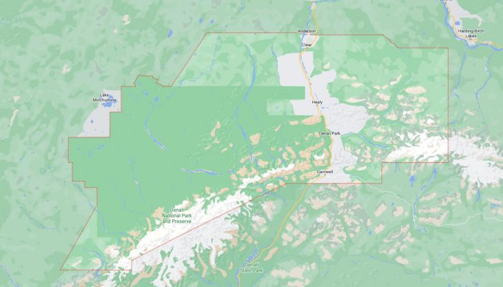
Cities and Towns in Denali Borough, Alaska

Founded in 1990, Denali Borough is one of 20 boroughs in the state of Alaska. The city of Healy is the borough seat. With FIPS code of 68, Denali Borough has a population of 1,593 and area of 12,641 square miles (32,740 km²).

List of all cities in Denali Borough, AK alphabetically

City/Town Postal Code Area Code
Anderson, AK 99744 907
Cantwell, AK 99729 907
Clear, AK 99704 907
Denali National Park, AK 99755 907
Healy, AK 99743 907
99755 907
Nenana, AK 99704 907
99744 907

Major Cities and Towns in Denali Borough, Alaska

Healy

Area, Population, and Coordinates

  • Area: 687.2 square miles
  • Population: 1,021 (as of the last census)
  • ZIP Codes: 99743
  • Latitude and Longitude:
    • Latitude: 63.8674° N
    • Longitude: 149.0177° W

Location and History

Healy is the largest community in Denali Borough, located along the George Parks Highway near the entrance to Denali National Park and Preserve. The town was originally established in the early 20th century as a coal mining camp for the Usibelli Coal Mine, which remains a significant part of the local economy. Healy’s strategic location near Denali National Park has made it a popular stop for tourists traveling to the park, particularly during the summer months when the town’s population swells with seasonal workers and visitors. The area’s natural beauty, with stunning views of the Alaska Range and proximity to the Nenana River, has contributed to Healy’s development as a gateway community to one of Alaska’s most famous attractions.

Major Schools and Landmarks

Healy is served by the Denali Borough School District, with Tri-Valley School providing education from kindergarten through 12th grade. The town’s most notable landmarks include the Denali National Park and Preserve, which offers unparalleled opportunities for wildlife viewing, hiking, and exploring the wilderness. The Usibelli Coal Mine is another significant landmark, reflecting the area’s industrial heritage. The Nenana River provides opportunities for rafting and fishing, adding to the outdoor activities available in the area. Healy also serves as a starting point for the Denali Park Road, which offers access to the heart of the national park and its many natural wonders.

Anderson

Area, Population, and Coordinates

  • Area: 48.7 square miles
  • Population: 177 (as of the last census)
  • ZIP Codes: 99744
  • Latitude and Longitude:
    • Latitude: 64.3439° N
    • Longitude: 149.1875° W

Location and History

Anderson is a small city in Denali Borough, Alaska, located along the Nenana River, approximately 76 miles southwest of Fairbanks. The city was established in the early 1950s by homesteader Arthur Anderson, after whom the town is named. Anderson grew slowly over the years, largely supported by its proximity to Clear Air Force Station, a military installation that plays a key role in missile defense and early warning systems. The city offers a quiet, rural lifestyle with a strong sense of community. Its location near the Nenana River provides residents with access to outdoor activities such as fishing, hunting, and snowmobiling, which are central to life in this remote part of Alaska.

Major Schools and Landmarks

Anderson is part of the Denali Borough School District, with students attending Anderson School, which provides education from kindergarten through 12th grade. The town’s most significant landmark is Clear Air Force Station, which is located just a few miles away and remains an important employer in the area. The Nenana River, which flows near the town, offers opportunities for fishing, boating, and other outdoor recreation. The surrounding wilderness provides a pristine environment for hunting and exploring the natural beauty of interior Alaska. Anderson’s quiet setting and close-knit community make it a unique and welcoming place for those who prefer a rural lifestyle.

Cantwell

Area, Population, and Coordinates

  • Area: 457.5 square miles
  • Population: 219 (as of the last census)
  • ZIP Codes: 99729
  • Latitude and Longitude:
    • Latitude: 63.3911° N
    • Longitude: 148.9503° W

Location and History

Cantwell is a small community in Denali Borough, Alaska, located at the junction of the George Parks Highway and Denali Highway, about 30 miles south of the entrance to Denali National Park and Preserve. The area was originally inhabited by the Athabascan people, who used the surrounding lands for hunting and fishing. Cantwell was established as a railroad construction camp during the early 20th century, serving as a key supply point for the Alaska Railroad. Over time, Cantwell developed into a small but important community, supporting both the railroad and the growing tourism industry associated with Denali National Park. The town’s location near the Alaska Range offers stunning views and easy access to some of the state’s most rugged and beautiful landscapes.

Major Schools and Landmarks

Cantwell is served by the Denali Borough School District, with students attending Tri-Valley School in Healy. The town’s most notable landmarks include the Denali Highway, which offers a scenic drive through some of Alaska’s most remote wilderness areas, with opportunities for wildlife viewing, fishing, and camping. The nearby Nenana River provides additional recreational activities, including rafting and fishing. Cantwell’s proximity to Denali National Park makes it a convenient stop for travelers and adventurers heading into the park. The town’s history as a railroad community is reflected in its continued importance as a transportation hub for the region.

Map of Cities in Denali Borough, AK

Map of Cities in Denali Borough, AK