New Mexico Counties List

There are a total of 33 counties in the state of New Mexico. Among them, Bernalillo County is the oldest one (established in 1852) while Cibola County is the youngest (established in 1981).  With population of 670,968, Bernalillo County is the most populated. The biggest county by land area is Catron County (17,943 km²) and the smallest is Los Alamos County (282 km²).

Largest Counties in New Mexico

1. Catron County

County Seat: Reserve

  • Area: 6,929 square miles
  • Population: 3,579 (as of 2020 census)
  • Area Codes: 575
  • Latitude: 33.8797° N
  • Longitude: 108.8966° W

Location and History

Catron County is located in western New Mexico, bordered by Arizona to the west. It is the largest county in New Mexico by area, yet it is one of the least populated. Catron County was established in 1921 and named after Thomas Benton Catron, a U.S. Senator and a leading figure in New Mexico’s early history. The county’s rugged terrain includes portions of the Gila National Forest and the Continental Divide. Historically, the area was inhabited by Apache and Navajo tribes before European exploration.

Major Highways and Landmarks

Catron County is traversed by U.S. Route 60 and New Mexico State Road 12, which connect various small communities within the county. The Gila Wilderness, a major landmark, is one of the largest wilderness areas in the United States, offering a pristine environment for hiking, camping, and wildlife observation. Other significant landmarks include the Apache Creek Pueblo, a prehistoric archaeological site, and the Plains of San Agustin, known for its large, ancient lakebed.

2. Chaves County

County Seat: Roswell

  • Area: 6,071 square miles
  • Population: 64,615 (as of 2020 census)
  • Area Codes: 575
  • Latitude: 33.3943° N
  • Longitude: 104.5230° W

Location and History

Chaves County is located in southeastern New Mexico, with its county seat, Roswell, serving as the largest city. Established in 1889, Chaves County was named after José Francisco Chaves, a prominent figure in New Mexico’s territorial history. The county is historically significant due to the 1947 Roswell Incident, an event that has cemented Roswell’s place in UFO lore and pop culture. The area was traditionally inhabited by Native American tribes, and later saw significant ranching and agricultural development.

Major Highways and Landmarks

U.S. Highways 70, 285, and 380 intersect in Roswell, making it a key transportation hub in southeastern New Mexico. The International UFO Museum and Research Center in Roswell is a major tourist attraction, drawing visitors interested in the alleged UFO crash of 1947. Bitter Lake National Wildlife Refuge, located northeast of Roswell, is another important landmark, providing a habitat for migratory birds and other wildlife. Additionally, Bottomless Lakes State Park offers scenic views and recreational activities.

3. Cibola County

County Seat: Grants

  • Area: 4,539 square miles
  • Population: 27,172 (as of 2020 census)
  • Area Codes: 505
  • Latitude: 35.0763° N
  • Longitude: 107.9010° W

Location and History

Cibola County, located in western New Mexico, was established in 1981, making it one of the youngest counties in the state. The county was formed from the western portion of Valencia County and is named after the legendary Seven Cities of Cibola, which were sought by Spanish explorers in the 16th century. The county has a rich cultural history, with ties to both Pueblo and Navajo communities, and includes several Native American reservations.

Major Highways and Landmarks

Interstate 40 and U.S. Route 66 (now decommissioned) run through Cibola County, providing vital transportation links. The county is home to the El Malpais National Monument, known for its unique volcanic landscape, and Acoma Pueblo, one of the oldest continuously inhabited communities in North America. Mount Taylor, a sacred mountain to several Native American tribes, is another significant landmark, offering hiking and panoramic views.

4. San Juan County

County Seat: Aztec

  • Area: 5,538 square miles
  • Population: 121,661 (as of 2020 census)
  • Area Codes: 505
  • Latitude: 36.5286° N
  • Longitude: 108.0445° W

Location and History

San Juan County is located in the northwestern corner of New Mexico, bordering Arizona, Utah, and Colorado. Established in 1887, it was named after the San Juan River, which flows through the county. The area has a rich history of Native American habitation, particularly by the Navajo Nation, which occupies a significant portion of the county. The county’s economy has traditionally been based on natural resources, including oil, gas, and coal.

Major Highways and Landmarks

San Juan County is served by U.S. Highways 64, 550, and 491. The county is famous for the Aztec Ruins National Monument, a well-preserved example of Ancestral Puebloan architecture. The Bisti/De-Na-Zin Wilderness offers a unique landscape of badlands, while the San Juan River is renowned for its world-class trout fishing. The Four Corners Monument, where New Mexico, Arizona, Utah, and Colorado meet, is another notable landmark.

5. Socorro County

County Seat: Socorro

  • Area: 6,649 square miles
  • Population: 16,595 (as of 2020 census)
  • Area Codes: 575
  • Latitude: 34.0584° N
  • Longitude: 106.8914° W

Location and History

Socorro County is located in central New Mexico, encompassing a large area that includes the Rio Grande River. The county was one of the original nine established when New Mexico became a U.S. Territory in 1852. The name “Socorro” means “help” or “aid,” referencing the assistance provided by the Piro Indians to the early Spanish colonists. The county has a deep historical connection to the Spanish colonial period and was a key location during the westward expansion of the United States.

Major Highways and Landmarks

Interstate 25 runs north-south through Socorro County, providing a major transportation corridor. U.S. Route 60 also passes through the county. The Very Large Array (VLA), a radio astronomy observatory, is one of the county’s most famous landmarks, known for its enormous dish antennas. Bosque del Apache National Wildlife Refuge, located along the Rio Grande, is another major site, particularly famous for birdwatching during the winter migration season.

6. McKinley County

County Seat: Gallup

  • Area: 5,455 square miles
  • Population: 72,902 (as of 2020 census)
  • Area Codes: 505
  • Latitude: 35.5054° N
  • Longitude: 108.7426° W

Location and History

McKinley County, situated in the western part of New Mexico, was established in 1901 and named after President William McKinley. The county has a diverse cultural history, heavily influenced by Navajo, Zuni, and Hopi populations. Gallup, the county seat, has long been a hub for trade and commerce, especially during the railroad era. The region has a history of uranium mining, which played a significant role in its mid-20th-century economy.

Major Highways and Landmarks

Interstate 40 and U.S. Route 491 are major highways in McKinley County, facilitating travel through the region. Gallup is famous for its annual Inter-Tribal Indian Ceremonial, a major event celebrating Native American culture. The county is also home to the Zuni Pueblo, known for its rich artistic heritage, and the Red Rock Park, which features striking red sandstone formations. Chaco Culture National Historical Park, although partially in San Juan County, is easily accessible from McKinley County and is a UNESCO World Heritage site.

7. Grant County

County Seat: Silver City

  • Area: 3,967 square miles
  • Population: 27,767 (as of 2020 census)
  • Area Codes: 575
  • Latitude: 32.7799° N
  • Longitude: 108.3923° W

Location and History

Grant County is located in the southwestern part of New Mexico, bordering Arizona. It was established in 1868 and named after Ulysses S. Grant, the 18th President of the United States. The county is historically significant due to its mining heritage, particularly for copper, silver, and gold. Silver City, the county seat, developed during the mining boom of the late 19th century and has since grown into a cultural and educational center.

Major Highways and Landmarks

U.S. Routes 180 and 90 are the main highways in Grant County. The county is home to the Gila Cliff Dwellings National Monument, an important archaeological site showcasing the remains of ancient Native American dwellings. The Gila National Forest, which covers much of the county, offers extensive opportunities for outdoor recreation, including hiking, camping, and birdwatching. The historic downtown of Silver City, with its well-preserved architecture and vibrant arts scene, is also a major attraction.

8. Otero County

County Seat: Alamogordo

  • Area: 6,628 square miles
  • Population: 67,839 (as of 2020 census)
  • Area Codes: 575
  • Latitude: 32.6519° N
  • Longitude: 105.9787° W

Location and History

Otero County is located in southern New Mexico, bordered by Texas to the east. Established in 1899, the county was named after Miguel Antonio Otero, the governor of the New Mexico Territory at the time. The county has a rich history connected to Native American cultures, the U.S. military, and the space program. Alamogordo, the county seat, is known for its proximity to the White Sands National Park and the Holloman Air Force Base.

Major Highways and Landmarks

U.S. Routes 54, 70, and 82 are the major highways serving Otero County. The county is best known for White Sands National Park, which features vast gypsum sand dunes and is a major tourist attraction. The nearby White Sands Missile Range, a military testing area, played a significant role in the development of space exploration technology. Another landmark is the Lincoln National Forest, which offers diverse landscapes ranging from desert to alpine environments.

9. Lincoln County

County Seat: Carrizozo

  • Area: 4,831 square miles
  • Population: 19,572 (as of 2020 census)
  • Area Codes: 575
  • Latitude: 33.5133° N
  • Longitude: 105.3847° W

Location and History

Lincoln County is situated in central New Mexico and is famous for its wild west history, particularly the Lincoln County War, a series of 19th-century conflicts involving famous figures like Billy the Kid. The county was established in 1869 and named after President Abraham Lincoln. Historically, the region was an important area for cattle ranching and later saw the development of tourism, particularly in the Ruidoso area.

Major Highways and Landmarks

U.S. Route 380 runs through Lincoln County, connecting key locations such as Carrizozo and Capitan. The county is known for the Lincoln Historic Site, which preserves buildings from the Lincoln County War era. Ruidoso, a popular mountain resort town, offers skiing in the winter and horse racing in the summer at Ruidoso Downs. The Mescalero Apache Reservation, home to the Mescalero Apache Tribe, is another significant area, offering cultural insights and natural beauty.

10. Sandoval County

County Seat: Bernalillo

  • Area: 3,716 square miles
  • Population: 148,834 (as of 2020 census)
  • Area Codes: 505
  • Latitude: 35.4251° N
  • Longitude: 106.4132° W

Location and History

Sandoval County is located in north-central New Mexico, just north of Albuquerque. Established in 1903, the county was named after the prominent Sandoval family, who were early Spanish settlers in the area. The county has a diverse history, with influences from Native American tribes, Spanish colonists, and Mexican settlers. It includes several Pueblo communities, which have maintained their cultural heritage for centuries.

Major Highways and Landmarks

Interstate 25 and U.S. Route 550 are the primary highways in Sandoval County. The county is home to significant landmarks such as the Jemez Mountains, known for their stunning scenery and outdoor recreational opportunities, and the Bandelier National Monument, which preserves ancient Puebloan cliff dwellings. The county seat, Bernalillo, hosts the annual Las Fiestas de San Lorenzo, a cultural celebration with deep historical roots. The Santa Ana Star Casino and the Hyatt Regency Tamaya Resort, located on the Santa Ana Pueblo, are major attractions for visitors.

List of All Counties in New Mexico

Below please see all New Mexico counties which are listed in alphabetical order.

  1. Bernalillo County, NM
  2. Catron County, NM
  3. Chaves County, NM
  4. Cibola County, NM
  5. Colfax County, NM
  6. Curry County, NM
  7. De Baca County, NM
  8. Doña Ana County, NM
  9. Eddy County, NM
  10. Grant County, NM
  11. Guadalupe County, NM
  12. Harding County, NM
  13. Hidalgo County, NM
  14. Lea County, NM
  15. Lincoln County, NM
  16. Los Alamos County, NM
  17. Luna County, NM
  18. McKinley County, NM
  19. Mora County, NM
  20. Otero County, NM
  21. Quay County, NM
  22. Rio Arriba County, NM
  23. Roosevelt County, NM
  24. Sandoval County, NM
  25. San Juan County, NM
  26. San Miguel County, NM
  27. Santa Fe County, NM
  28. Sierra County, NM
  29. Socorro County, NM
  30. Taos County, NM
  31. Torrance County, NM
  32. Union County, NM
  33. Valencia County, NM

Map of New Mexico Counties
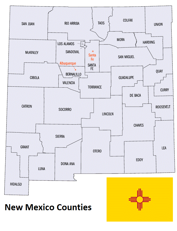
Map of New Mexico Counties