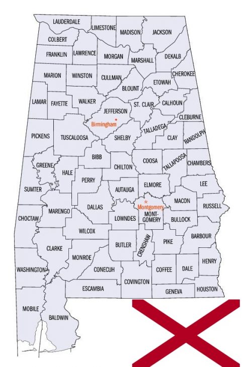
Alabama Counties. List Alphabetically (and by Population)
How many counties are there in Alabama? As of 2024, there are a total of 67 counties in the state of Alabama. Among them, Washington County is the oldest one (established in 1800) while Houston County is the youngest (established in 1903). With population of 658,466, Jefferson County is the most populated. The biggest county by land area is Baldwin County (4,118 km²) and the smallest is Etowah County (1,386 km²).
Largest Counties in Alabama
1. Baldwin County
County Seat: Bay Minette
- Area: 2,027 square miles
- Population: Approximately 239,589 (2020 census)
- Area Codes: 251
- Latitude: 30.6592° N
- Longitude: 87.7460° W
Location and History
Baldwin County is located in the southwestern part of Alabama and is the largest county by area in the state. It was established on December 21, 1809, from parts of Washington County. The county is named after Abraham Baldwin, a U.S. Senator from Georgia. Baldwin County’s early history is marked by its strategic location along the Gulf of Mexico, making it a significant site during the colonial period and the Civil War. The county has evolved from an area dominated by agriculture and fishing to one that includes diverse economic activities, including tourism, due to its beautiful Gulf Coast beaches.
Major Highways and Landmarks
Baldwin County is well-connected by several major highways, including Interstate 10, which runs east-west across the county, and U.S. Highways 31, 90, and 98. The county is home to several notable landmarks, such as Gulf State Park, the USS Alabama Battleship Memorial Park, and historic Fort Morgan. The county also boasts a rich cultural heritage, with landmarks such as the Baldwin County Courthouse in Bay Minette and the Eastern Shore Art Center in Fairhope.
2. Mobile County
County Seat: Mobile
- Area: 1,644 square miles
- Population: Approximately 414,659 (2020 census)
- Area Codes: 251
- Latitude: 30.6954° N
- Longitude: 88.0399° W
Location and History
Mobile County is situated in the southwestern corner of Alabama, bordering the Gulf of Mexico and Mississippi. It was established on December 18, 1812, from parts of Washington County and was named after the indigenous Mobile tribe. Mobile County has a rich history dating back to its founding by the French in 1702. The city of Mobile, one of the oldest in the United States, played a critical role in various historical events, including the Civil War. The county’s strategic location as a port city has shaped its economy, making it a hub for trade, shipbuilding, and manufacturing.
Major Highways and Landmarks
Mobile County is served by Interstate 10 and Interstate 65, which facilitate travel across the region. Major U.S. Highways include 43, 45, 90, and 98. The county is known for landmarks such as the historic Fort Conde, the USS Alabama Battleship, and Bellingrath Gardens and Home. Mobile County also hosts the annual Mardi Gras celebration, one of the oldest in the United States. Additionally, the county is home to the Mobile-Tensaw River Delta, one of the largest river delta systems in the United States.
3. Jefferson County
County Seat: Birmingham
- Area: 1,124 square miles
- Population: Approximately 674,721 (2020 census)
- Area Codes: 205, 659
- Latitude: 33.5186° N
- Longitude: 86.8104° W
Location and History
Jefferson County is located in the central part of Alabama and is the most populous county in the state. It was established on December 13, 1819, and was named after Thomas Jefferson, the third President of the United States. The county’s history is closely tied to the development of the steel industry, particularly in its county seat, Birmingham, which earned the nickname “The Magic City” due to its rapid growth. Jefferson County played a significant role in the civil rights movement during the 1950s and 1960s, with Birmingham being a focal point for protests and demonstrations.
Major Highways and Landmarks
Jefferson County is a major transportation hub with Interstates 20, 22, 59, and 65 passing through it. The county is also served by U.S. Highways 31, 78, 280, and 411. Significant landmarks in Jefferson County include the Birmingham Civil Rights Institute, Vulcan Park and Museum, and the Alabama Theatre. The county is also home to Red Mountain Park, one of the largest urban parks in the United States. Additionally, the University of Alabama at Birmingham (UAB) contributes to the county’s status as a center for education and healthcare.
4. Madison County
County Seat: Huntsville
- Area: 813 square miles
- Population: Approximately 388,153 (2020 census)
- Area Codes: 256, 938
- Latitude: 34.7304° N
- Longitude: 86.5861° W
Location and History
Madison County is located in the northern part of Alabama, bordering Tennessee. It was established on December 13, 1808, and was named after James Madison, the fourth President of the United States. Huntsville, the county seat, is known as “Rocket City” due to its significant contributions to the U.S. space program, particularly through NASA’s Marshall Space Flight Center. The county’s early history was dominated by cotton plantations, but its economy transitioned to technology and aerospace industries during the 20th century.
Major Highways and Landmarks
Madison County is well-served by Interstate 565, which connects the area to other parts of the state, and U.S. Highways 72 and 431. Major landmarks include the U.S. Space & Rocket Center, Monte Sano State Park, and the Huntsville Botanical Garden. The county is also home to Redstone Arsenal, a key military installation that supports the U.S. Army and NASA. Additionally, historic sites such as the Twickenham Historic District and Constitution Hall Park reflect the county’s rich history.
5. Shelby County
County Seat: Columbiana
- Area: 810 square miles
- Population: Approximately 223,024 (2020 census)
- Area Codes: 205, 659
- Latitude: 33.1825° N
- Longitude: 86.6091° W
Location and History
Shelby County is situated in the central part of Alabama, just southeast of Birmingham. It was established on February 7, 1818, and is named after Isaac Shelby, a Revolutionary War hero and the first Governor of Kentucky. The county’s history is rooted in agriculture, but it has grown into one of the most prosperous counties in the state, with a diverse economy that includes manufacturing, services, and retail. The county’s proximity to Birmingham has also spurred suburban development, making it one of the fastest-growing counties in Alabama.
Major Highways and Landmarks
Shelby County is traversed by Interstate 65, which runs north-south, and U.S. Highway 280, a major east-west route. Key landmarks include Oak Mountain State Park, the largest state park in Alabama, and the American Village, a living history museum in Montevallo. The county is also home to the University of Montevallo, Alabama’s only public liberal arts college. Additionally, the county features numerous recreational areas, such as Lay Lake and the Shelby County Museum and Archives in Columbiana, which preserves the county’s history.
6. Tuscaloosa County
County Seat: Tuscaloosa
- Area: 1,351 square miles
- Population: Approximately 227,036 (2020 census)
- Area Codes: 205, 659
- Latitude: 33.2098° N
- Longitude: 87.5692° W
Location and History
Tuscaloosa County is located in the west-central part of Alabama, along the Black Warrior River. It was established on February 6, 1818, and named after the Native American chief Tuskaloosa, who fought against Hernando de Soto in 1540. The county’s history is closely linked to the University of Alabama, which was established in 1831 and became a major center of education and culture in the state. Tuscaloosa, the county seat, served as the state capital from 1826 to 1846 before it was moved to Montgomery.
Major Highways and Landmarks
Tuscaloosa County is served by major highways such as Interstates 20 and 59, which merge as they pass through the county, and U.S. Highways 11, 43, 82, and 69. Major landmarks include the University of Alabama campus, the Bryant-Denny Stadium, and the Paul W. Bryant Museum. The county is also home to Lake Tuscaloosa and Moundville Archaeological Park, one of the most significant prehistoric Native American sites in the United States. Additionally, the Tuscaloosa Amphitheater and the Tuscaloosa Riverwalk are popular destinations for residents and visitors alike.
7. Covington County
County Seat: Andalusia
- Area: 1,044 square miles
- Population: Approximately 37,570 (2020 census)
- Area Codes: 334
- Latitude: 31.3088° N
- Longitude: 86.5023° W
Location and History
Covington County is located in the southern part of Alabama, near the Florida border. It was established on December 17, 1821, and named after Brigadier General Leonard Covington, a hero of the War of 1812. The county’s early history was influenced by its location along the Conecuh River, which facilitated the transport of timber and other goods. Agriculture, particularly cotton, was the dominant industry in the county for many years. The county seat, Andalusia, developed as a center of trade and commerce, especially with the arrival of the railroad in the late 19th century.
Major Highways and Landmarks
Covington County is accessible via major highways, including U.S. Highways 29, 84, and 331, which connect it to other parts of Alabama and Florida. Key landmarks in the county include the Three Notch Museum in Andalusia, which preserves the county’s history, and Frank Jackson State Park, a popular destination for fishing and camping. The Conecuh National Forest, which extends into Covington County, offers additional recreational opportunities. The county is also known for its annual events, such as the World Championship Domino Tournament held in Andalusia.
8. Montgomery County
County Seat: Montgomery
- Area: 800 square miles
- Population: Approximately 226,941 (2020 census)
- Area Codes: 334
- Latitude: 32.3668° N
- Longitude: 86.3000° W
Location and History
Montgomery County is located in the central part of Alabama and is home to the state capital, Montgomery. The county was established on December 6, 1816, and was named after Major Lemuel P. Montgomery, a hero of the Battle of Horseshoe Bend during the War of 1812. Montgomery’s history is deeply intertwined with significant events in American history, including the Civil War and the civil rights movement. The city served as the first capital of the Confederacy and was later the site of the Montgomery Bus Boycott, which marked a pivotal moment in the civil rights movement.
Major Highways and Landmarks
Montgomery County is served by major highways such as Interstates 65 and 85, which intersect in Montgomery, and U.S. Highways 80, 231, and 331. Major landmarks include the Alabama State Capitol, the Dexter Avenue King Memorial Baptist Church, and the Rosa Parks Museum. The county is also home to the Montgomery Museum of Fine Arts, the Alabama Shakespeare Festival, and the Montgomery Zoo. Additionally, historic sites such as Old Alabama Town and the First White House of the Confederacy attract visitors interested in the county’s rich history.
9. Houston County
County Seat: Dothan
- Area: 582 square miles
- Population: Approximately 107,202 (2020 census)
- Area Codes: 334
- Latitude: 31.1566° N
- Longitude: 85.3550° W
Location and History
Houston County is located in the southeastern corner of Alabama, bordering Georgia and Florida. It was established on February 9, 1903, and was named after George S. Houston, a former governor of Alabama. The county seat, Dothan, is known as the “Peanut Capital of the World” due to its significant peanut production. Houston County’s history is relatively recent compared to other Alabama counties, with Dothan developing rapidly in the early 20th century as an agricultural and commercial center. The arrival of the railroad further spurred growth, making Dothan a key trade hub in the region.
Major Highways and Landmarks
Houston County is served by major highways such as U.S. Highways 84, 231, and 431, which connect it to nearby states and major cities. Notable landmarks include the Dothan Area Botanical Gardens, Landmark Park, and the Wiregrass Museum of Art. The county also hosts the annual National Peanut Festival, celebrating the region’s agricultural heritage. The Dothan Opera House and the George Washington Carver Interpretive Museum are important cultural sites, reflecting the county’s rich history and diverse community.
10. Lee County
County Seat: Opelika
- Area: 616 square miles
- Population: Approximately 174,241 (2020 census)
- Area Codes: 334
- Latitude: 32.6010° N
- Longitude: 85.3535° W
Location and History
Lee County is located in the eastern part of Alabama, bordering Georgia. It was established on December 5, 1866, and was named after Confederate General Robert E. Lee. The county seat, Opelika, developed as a key railroad hub in the late 19th century, while the nearby city of Auburn became known for its university, Auburn University, which was established in 1856. The county’s history is closely tied to agriculture, particularly cotton, but it has diversified over the years, with education, manufacturing, and services becoming dominant sectors.
Major Highways and Landmarks
Lee County is well-connected by major highways, including Interstate 85, which runs through the county, and U.S. Highways 29 and 280. Key landmarks include Auburn University, which is the heart of the county’s educational and cultural life, and Chewacla State Park, offering outdoor recreation. The Jule Collins Smith Museum of Fine Art in Auburn and the Opelika Historic District are also significant cultural sites. Additionally, the county hosts various annual events, such as Auburn’s A-Day football game and the Opelika Christmas Parade, reflecting the county’s vibrant community life.
List of All Counties in Alabama Alphabetically
Below please see all Alabama counties which are listed in alphabetical order.
- Autauga County, AL
- Baldwin County, AL
- Barbour County, AL
- Bibb County, AL
- Blount County, AL
- Bullock County, AL
- Butler County, AL
- Calhoun County, AL
- Chambers County, AL
- Cherokee County, AL
- Chilton County, AL
- Choctaw County, AL
- Clarke County, AL
- Clay County, AL
- Cleburne County, AL
- Coffee County, AL
- Colbert County, AL
- Conecuh County, AL
- Coosa County, AL
- Covington County, AL
- Crenshaw County, AL
- Cullman County, AL
- Dale County, AL
- Dallas County, AL
- DeKalb County, AL
- Elmore County, AL
- Escambia County, AL
- Etowah County, AL
- Fayette County, AL
- Franklin County, AL
- Geneva County, AL
- Greene County, AL
- Hale County, AL
- Henry County, AL
- Houston County, AL
- Jackson County, AL
- Jefferson County, AL
- Lamar County, AL
- Lauderdale County, AL
- Lawrence County, AL
- Lee County, AL
- Limestone County, AL
- Lowndes County, AL
- Macon County, AL
- Madison County, AL
- Marengo County, AL
- Marion County, AL
- Marshall County, AL
- Mobile County, AL
- Monroe County, AL
- Montgomery County, AL
- Morgan County, AL
- Perry County, AL
- Pickens County, AL
- Pike County, AL
- Randolph County, AL
- Russell County, AL
- Saint Clair County, AL
- Shelby County, AL
- Sumter County, AL
- Talladega County, AL
- Tallapoosa County, AL
- Tuscaloosa County, AL
- Walker County, AL
- Washington County, AL
- Wilcox County, AL
- Winston County, AL