Montana Counties. List Alphabetically (and by Population)

How many counties are there in Montana? As of 2024, there are a total of 56 counties in the state of Montana. Among them, Beaverhead County is the oldest one (established in 1864) while Petroleum County is the youngest (established in 1926).  With population of 155,634, Yellowstone County is the most populated. The biggest county by land area is Beaverhead County (14,356 km²) and the smallest is Silver Bow County (1,860 km²).

Largest Counties in Montana

1. Beaverhead County

County Seat: Dillon

  • Area: 5,572 square miles
  • Population: Approximately 9,453
  • Area Codes: 406
  • Latitude and Longitude: 45.2159° N, 112.6334° W

Location and History

Beaverhead County, located in southwestern Montana, is the largest county in the state by area. It was established in 1865 and named after the Beaverhead Rock, a landmark that guided early explorers. The county has a rich history tied to the Lewis and Clark Expedition, which passed through the area in 1805. Dillon, the county seat, was founded as a railroad town in the 1880s and quickly became a center for agriculture, particularly cattle ranching and sheep herding. The county’s vast landscapes include mountain ranges, rivers, and valleys, making it a prime area for outdoor activities such as fishing, hunting, and hiking.

Major Highways and Landmarks

Beaverhead County is accessible via major highways such as Interstate 15, which runs north-south through the county, connecting it to Butte and Idaho. U.S. Route 287 and Montana Highway 41 also serve the area. Notable landmarks include the Beaverhead-Deerlodge National Forest, which offers extensive recreational opportunities, and the Big Hole National Battlefield, a site commemorating a battle between the Nez Perce tribe and the U.S. Army in 1877. The county is also home to the Clark Canyon Reservoir, a popular destination for boating and fishing, and Bannack State Park, which preserves the ghost town of Bannack, Montana’s first territorial capital.

2. Missoula County

County Seat: Missoula

  • Area: 2,618 square miles
  • Population: Approximately 119,600
  • Area Codes: 406
  • Latitude and Longitude: 46.8625° N, 113.9940° W

Location and History

Missoula County is located in western Montana and is one of the most populous counties in the state. The county was established in 1860, and its name comes from a Salish word meaning “near the cold, chilling waters.” Missoula, the county seat, is a vibrant city known for its educational institutions, particularly the University of Montana, which was founded in 1893. The area’s history is closely tied to the lumber industry, with the Hellgate Trading Post established in the 1860s as a center for trade and lumber processing. Over the years, Missoula has grown into a cultural and economic hub, with a diverse economy that includes education, healthcare, and outdoor recreation.

Major Highways and Landmarks

Missoula County is served by major highways such as Interstate 90, which runs east-west through the county, and U.S. Route 93, which runs north-south. Montana Highway 200 also passes through the county. Notable landmarks include the University of Montana campus, which features the iconic Main Hall and the “M” on Mount Sentinel. The county is also home to the Rattlesnake National Recreation Area, which offers hiking, mountain biking, and wildlife viewing, and the historic Fort Missoula, a 19th-century military post. The Missoula Art Museum and the annual Missoula Marathon are also key cultural attractions in the region.

3. Ravalli County

County Seat: Hamilton

  • Area: 2,400 square miles
  • Population: Approximately 43,172
  • Area Codes: 406
  • Latitude and Longitude: 46.2069° N, 114.1607° W

Location and History

Ravalli County is located in the southwestern part of Montana, nestled in the Bitterroot Valley. The county was established in 1893 and named after Father Anthony Ravalli, a Jesuit missionary who played a significant role in the early settlement of the area. Hamilton, the county seat, was founded by entrepreneur Marcus Daly in the late 19th century as a company town for his lumber and mining operations. Ravalli County has a rich history of agriculture, particularly in apple orchards and cattle ranching, and it remains an important agricultural region today. The Bitterroot Valley’s scenic beauty and mild climate have made it a popular destination for retirees and outdoor enthusiasts.

Major Highways and Landmarks

Ravalli County is accessible via U.S. Route 93, which runs north-south through the county, connecting it to Missoula and Idaho. Montana Highway 38 provides access to the east. Notable landmarks include the Lee Metcalf National Wildlife Refuge, which offers excellent birdwatching and wildlife viewing opportunities, and the Daly Mansion, the historic home of Marcus Daly, which is open for tours. The county is also home to the Bitterroot National Forest, which offers a wide range of outdoor activities, including hiking, camping, and fishing. The annual Bitterroot Celtic Games and Gathering in Hamilton celebrates the county’s Scottish heritage and is a popular cultural event.

4. Flathead County

County Seat: Kalispell

  • Area: 5,256 square miles
  • Population: Approximately 104,357
  • Area Codes: 406
  • Latitude and Longitude: 48.2006° N, 114.3153° W

Location and History

Flathead County is located in northwestern Montana, bordered by Canada to the north and the Rocky Mountains to the east. The county was established in 1893 and named after the Flathead Native American tribe. Kalispell, the county seat, was founded in 1891 as a railroad town and quickly became the economic center of the region. Flathead County is known for its stunning natural landscapes, including Flathead Lake, the largest freshwater lake west of the Mississippi River, and Glacier National Park, one of the most famous national parks in the United States. The county’s economy is heavily reliant on tourism, agriculture, and timber.

Major Highways and Landmarks

Flathead County is served by major highways such as U.S. Route 2, which runs east-west through the county, and U.S. Route 93, which runs north-south. Montana Highway 35 provides access to the eastern shore of Flathead Lake. Notable landmarks include Glacier National Park, known for its rugged mountains, pristine lakes, and diverse wildlife. The county is also home to the Whitefish Mountain Resort, a popular destination for skiing and snowboarding, and the Conrad Mansion Museum in Kalispell, a well-preserved example of Victorian architecture. Flathead Lake offers boating, fishing, and other water activities, making it a major draw for tourists.

5. Lewis and Clark County

County Seat: Helena

  • Area: 3,459 square miles
  • Population: Approximately 69,432
  • Area Codes: 406
  • Latitude and Longitude: 46.5927° N, 112.0361° W

Location and History

Lewis and Clark County is located in west-central Montana and is named after the famous explorers Meriwether Lewis and William Clark. The county was established in 1865, and Helena, the county seat, was founded in 1864 during the Montana Gold Rush. Helena quickly grew into a wealthy city, known for its grand mansions and historic buildings, many of which were financed by gold mining profits. Today, Helena is the state capital of Montana and serves as a political, cultural, and economic center. The county’s history is closely tied to its role in the development of Montana as a state, and it continues to be a hub of government and commerce.

Major Highways and Landmarks

Lewis and Clark County is accessible via major highways such as Interstate 15, which runs north-south through the county, and U.S. Route 12, which runs east-west. U.S. Route 287 also passes through the county, providing additional access. Notable landmarks include the Montana State Capitol in Helena, a historic building with a stunning rotunda and numerous works of art. The county is also home to the Cathedral of St. Helena, an impressive Gothic Revival cathedral, and the Gates of the Mountains Wilderness, a scenic area along the Missouri River that was famously explored by Lewis and Clark. The Great Northern Carousel and ExplorationWorks, a science and culture museum, are popular attractions for families.

6. Sanders County

County Seat: Thompson Falls

  • Area: 2,790 square miles
  • Population: Approximately 12,113
  • Area Codes: 406
  • Latitude and Longitude: 47.5999° N, 115.3222° W

Location and History

Sanders County is located in northwestern Montana, along the Idaho border. The county was established in 1905 and named after Wilbur F. Sanders, a pioneer and U.S. Senator from Montana. Thompson Falls, the county seat, was founded in the late 19th century as a logging and mining town, and it remains a small but vibrant community. The county’s economy has traditionally been based on natural resources, including timber and mining, though tourism has become increasingly important in recent years. The rugged terrain of the Cabinet Mountains and the Clark Fork River provide a stunning backdrop to life in Sanders County, attracting outdoor enthusiasts and nature lovers.

Major Highways and Landmarks

Sanders County is served by major highways such as U.S. Route 200, which runs east-west through the county, and Montana Highway 135, which connects to Interstate 90 to the south. Notable landmarks include the Cabinet Mountains Wilderness, a protected area that offers hiking, camping, and wildlife viewing in a pristine mountain environment. The county is also home to the Thompson Falls Dam, a historic hydroelectric dam that continues to generate power for the region. The Clark Fork River provides excellent opportunities for fishing and boating, and the Noxon Reservoir is a popular spot for water recreation. The annual Sanders County Fair in Plains is a key cultural event, showcasing the county’s agricultural heritage.

7. Park County

County Seat: Livingston

  • Area: 2,813 square miles
  • Population: Approximately 16,606
  • Area Codes: 406
  • Latitude and Longitude: 45.6614° N, 110.5613° W

Location and History

Park County is located in south-central Montana, bordering Yellowstone National Park to the south. The county was established in 1887 and named for its proximity to Yellowstone, the first national park in the world. Livingston, the county seat, developed as a gateway to Yellowstone and a key railroad town in the late 19th century. The county’s economy has long been tied to tourism, with visitors flocking to the region for its stunning landscapes, outdoor recreation, and access to Yellowstone. In addition to tourism, agriculture, particularly cattle ranching, plays a significant role in the county’s economy.

Major Highways and Landmarks

Park County is accessible via major highways such as Interstate 90, which runs east-west through the county, and U.S. Route 89, which provides a direct route to Yellowstone National Park. Montana Highway 540 is also an important route within the county. Notable landmarks include the northern entrance to Yellowstone National Park, located at Gardiner, which is marked by the historic Roosevelt Arch. The county is also home to the Paradise Valley, a picturesque region along the Yellowstone River, and the Absaroka-Beartooth Wilderness, which offers some of the most rugged and scenic hiking in Montana. The Livingston Depot Center, a restored railroad station, now serves as a museum and cultural center, highlighting the county’s railroad heritage.

8. Carbon County

County Seat: Red Lodge

  • Area: 2,062 square miles
  • Population: Approximately 10,725
  • Area Codes: 406
  • Latitude and Longitude: 45.1894° N, 109.2477° W

Location and History

Carbon County is located in southern Montana, along the Wyoming border. The county was established in 1895 and named for the rich coal deposits found in the region. Red Lodge, the county seat, was originally a coal mining town and has since become a popular destination for outdoor recreation and tourism. The county’s history is closely tied to the mining industry, though today, tourism and agriculture are the mainstays of the economy. The Beartooth Mountains, which rise dramatically to the west of Red Lodge, provide a stunning backdrop and attract visitors year-round for skiing, hiking, and other outdoor activities.

Major Highways and Landmarks

Carbon County is accessible via major highways such as U.S. Route 212, known as the Beartooth Highway, which runs through the county and provides a scenic route to Yellowstone National Park. Montana Highway 78 connects Red Lodge to Interstate 90 to the north. Notable landmarks include the Beartooth Pass, one of the most scenic drives in the United States, offering breathtaking views of the Beartooth Mountains and surrounding wilderness. The county is also home to the Red Lodge Mountain Resort, a popular ski area, and the Carbon County Historical Society and Museum, which preserves the history of the region’s mining and pioneer heritage. The annual Red Lodge Rodeo and Fourth of July Parade are major cultural events that draw visitors from across the region.

9. Madison County

County Seat: Virginia City

  • Area: 3,587 square miles
  • Population: Approximately 8,600
  • Area Codes: 406
  • Latitude and Longitude: 45.2922° N, 111.9422° W

Location and History

Madison County is located in southwestern Montana, characterized by its mountainous terrain and rich history. The county was established in 1865 and named after James Madison, the fourth President of the United States. Virginia City, the county seat, is a well-preserved ghost town that was once the center of the Montana Gold Rush in the 1860s. The discovery of gold in Alder Gulch led to a rush of miners and the rapid development of Virginia City as the territorial capital of Montana. Today, Madison County is known for its historical sites, as well as its agricultural economy, particularly cattle ranching and farming.

Major Highways and Landmarks

Madison County is served by major highways such as U.S. Route 287, which runs north-south through the county, and Montana Highway 41, which connects to Interstate 90. Notable landmarks include Virginia City and Nevada City, both of which are preserved as living history museums that offer a glimpse into Montana’s gold rush era. The county is also home to the Madison River, renowned for its fly fishing, and the Ruby Valley, a scenic area known for its ranches and outdoor recreation opportunities. The Tobacco Root Mountains and the Gravelly Range provide stunning backdrops and numerous hiking trails. The annual Virginia City Players performances in the historic opera house are a cultural highlight.

10. Fergus County

County Seat: Lewistown

  • Area: 4,350 square miles
  • Population: Approximately 11,050
  • Area Codes: 406
  • Latitude and Longitude: 47.0620° N, 109.4275° W

Location and History

Fergus County is located in central Montana and is known for its rolling prairies and agricultural heritage. The county was established in 1885 and named after James Fergus, a prominent Montana pioneer and politician. Lewistown, the county seat, developed as a key center for agriculture, particularly wheat farming and cattle ranching, which remain central to the county’s economy today. Fergus County has a rich history tied to the early settlement of central Montana, with Lewistown serving as a hub for commerce and culture in the region. The county’s central location has made it a crossroads for transportation and trade.

Major Highways and Landmarks

Fergus County is accessible via major highways such as U.S. Route 87, which runs through Lewistown and connects the county to Great Falls and Billings. Montana Highway 200 also passes through the county, providing east-west access. Notable landmarks include the Central Montana Museum in Lewistown, which preserves the history of the region’s pioneers and Native American heritage. The county is also home to the Charles M. Russell National Wildlife Refuge, a vast area along the Missouri River that offers excellent opportunities for wildlife viewing and outdoor recreation. The Judith Mountains, located near Lewistown, provide hiking and exploration opportunities. The annual Lewistown Chokecherry Festival celebrates the local fruit and is a key cultural event in the region.

List of All Counties in Montana Alphabetically

Below please see all Montana counties which are listed in alphabetical order.

  1. Beaverhead County, MT
  2. Big Horn County, MT
  3. Blaine County, MT
  4. Broadwater County, MT
  5. Carbon County, MT
  6. Carter County, MT
  7. Cascade County, MT
  8. Chouteau County, MT
  9. Custer County, MT
  10. Daniels County, MT
  11. Dawson County, MT
  12. Deer Lodge County, MT
  13. Fallon County, MT
  14. Fergus County, MT
  15. Flathead County, MT
  16. Gallatin County, MT
  17. Garfield County, MT
  18. Glacier County, MT
  19. Golden Valley County, MT
  20. Granite County, MT
  21. Hill County, MT
  22. Jefferson County, MT
  23. Judith Basin County, MT
  24. Lake County, MT
  25. Lewis and Clark County, MT
  26. Liberty County, MT
  27. Lincoln County, MT
  28. Madison County, MT
  29. McCone County, MT
  30. Meagher County, MT
  31. Mineral County, MT
  32. Missoula County, MT
  33. Musselshell County, MT
  34. Park County, MT
  35. Petroleum County, MT
  36. Phillips County, MT
  37. Pondera County, MT
  38. Powder River County, MT
  39. Powell County, MT
  40. Prairie County, MT
  41. Ravalli County, MT
  42. Richland County, MT
  43. Roosevelt County, MT
  44. Rosebud County, MT
  45. Sanders County, MT
  46. Sheridan County, MT
  47. Silver Bow County, MT
  48. Stillwater County, MT
  49. Sweet Grass County, MT
  50. Teton County, MT
  51. Toole County, MT
  52. Treasure County, MT
  53. Valley County, MT
  54. Wheatland County, MT
  55. Wibaux County, MT
  56. Yellowstone County, MT

Map of Montana Counties
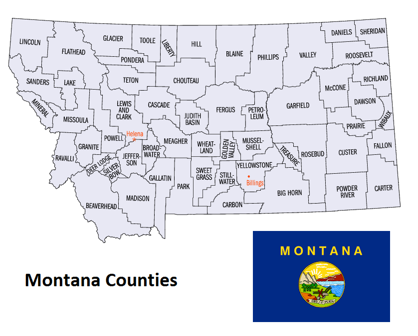
Map of Montana Counties