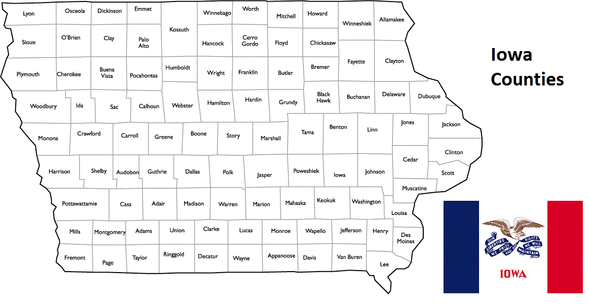
Iowa Counties. List Alphabetically (and by Population)
How many counties are there in Iowa? As of 2024, there are a total of 99 counties in the state of Iowa. Among them, Des Moines County is the oldest one (established in 1834) while Humboldt County is the youngest (established in 1857). With population of 430,640, Polk County is the most populated. The biggest county by land area is Kossuth County (2,520 km²) and the smallest is Dickinson County (987 km²).
Largest Counties in Iowa
1. Kossuth County
County Seat: Algona
- Area: 973 square miles
- Population: Approximately 15,543 (2020 census)
- Area Codes: 515
- Latitude: 43.0735° N
- Longitude: 94.2330° W
Location and History
Kossuth County, the largest county by area in Iowa, is located in the northern part of the state. It was established in 1851 and named after Lajos Kossuth, a Hungarian freedom fighter who symbolized the fight for independence. Algona, the county seat, was founded in 1854 and developed as a key community in the region, particularly after the arrival of the railroad in the late 19th century. The county’s economy has traditionally been based on agriculture, with corn, soybeans, and livestock playing significant roles. Kossuth County is also known for its rich history, particularly during World War II when a German POW camp was located in Algona, now commemorated by the Algona POW Museum.
Major Highways and Landmarks
Kossuth County is traversed by U.S. Highway 18, which runs east-west through the county, and U.S. Highway 169, which runs north-south. State Highway 9 also serves the region. Key landmarks include the aforementioned Algona POW Museum, which offers insights into the lives of German prisoners of war held in Iowa during World War II. The Kossuth County Historical Museum in Algona showcases the county’s history, with exhibits on local agriculture, industry, and daily life. The Ambrose A. Call State Park, named after one of the county’s early settlers, provides opportunities for hiking, picnicking, and enjoying the natural beauty of northern Iowa.
2. Pottawattamie County
County Seat: Council Bluffs
- Area: 958 square miles
- Population: Approximately 93,667 (2020 census)
- Area Codes: 712
- Latitude: 41.2619° N
- Longitude: 95.8608° W
Location and History
Pottawattamie County is located in southwestern Iowa, along the Missouri River. The county was established in 1848 and named after the Potawatomi Native American tribe, which once inhabited the region. Council Bluffs, the county seat, has a rich history as a key transportation hub, particularly during the westward expansion of the United States in the 19th century. The city was a major outfitting point for pioneers heading west on the Oregon Trail, and later became a critical railroad junction. Pottawattamie County’s economy is diverse, with agriculture, manufacturing, and services playing key roles. Council Bluffs also serves as a gateway to the Omaha metropolitan area, located just across the Missouri River.
Major Highways and Landmarks
Pottawattamie County is served by several major highways, including Interstates 80 and 29, which intersect in Council Bluffs, providing critical connections to Omaha, Des Moines, and other major cities. U.S. Highways 6 and 59 also traverse the county. Significant landmarks include the Union Pacific Railroad Museum in Council Bluffs, which tells the story of the transcontinental railroad and the role of the city in its development. The Historic General Dodge House, the former home of Civil War General Grenville M. Dodge, is another key attraction. The Loess Hills, a unique geological formation that runs through the western part of the county, offers scenic drives, hiking trails, and opportunities for nature observation. The county is also home to the Ameristar Casino Hotel, which draws visitors from the region.
3. Plymouth County
County Seat: Le Mars
- Area: 864 square miles
- Population: Approximately 25,177 (2020 census)
- Area Codes: 712
- Latitude: 42.7864° N
- Longitude: 96.1527° W
Location and History
Plymouth County is located in northwestern Iowa, near the borders with South Dakota and Nebraska. The county was established in 1851 and named after Plymouth, Massachusetts. Le Mars, the county seat, was founded in the 1870s and is known as the “Ice Cream Capital of the World” due to its association with Wells Enterprises, the maker of Blue Bunny ice cream. Plymouth County’s economy is heavily based on agriculture, with corn, soybeans, and livestock as major products, but Le Mars’ status as a center for dairy production also plays a significant role in the local economy. The county’s history includes early settlement by European immigrants, particularly Germans and Dutch, who established many of the communities still thriving today.
Major Highways and Landmarks
Plymouth County is accessible via U.S. Highway 75, which runs north-south through the county, and State Highways 3 and 12. Key landmarks include the Plymouth County Historical Museum in Le Mars, which preserves the history of the county with exhibits on local industries, agriculture, and daily life. The Ice Cream Days festival, held annually in Le Mars, celebrates the county’s connection to the dairy industry and draws visitors from across the region. The county is also home to several parks and recreation areas, including Hillview Recreation Area, which offers opportunities for hiking, fishing, and camping.
4. Woodbury County
County Seat: Sioux City
- Area: 873 square miles
- Population: Approximately 105,941 (2020 census)
- Area Codes: 712
- Latitude: 42.4919° N
- Longitude: 96.4003° W
Location and History
Woodbury County is located in western Iowa, along the Missouri River, and is part of the Sioux City metropolitan area. Established in 1851, the county was named after Levi Woodbury, a U.S. Senator and Associate Justice of the Supreme Court. Sioux City, the county seat, has a rich history as a transportation and industrial hub, particularly during the westward expansion of the United States. The city’s location at the confluence of the Missouri and Big Sioux rivers made it an important center for trade and industry. Today, Woodbury County’s economy is diverse, with significant contributions from manufacturing, agriculture, healthcare, and education.
Major Highways and Landmarks
Woodbury County is served by several major highways, including Interstate 29, which runs north-south along the Missouri River, and U.S. Highways 20, 75, and 77. Notable landmarks include the Sergeant Floyd Monument, a National Historic Landmark that commemorates Sergeant Charles Floyd, the only member of the Lewis and Clark Expedition to die during the journey. The Sioux City Public Museum and the Woodbury County Courthouse, an Art Deco masterpiece, are also significant attractions. The county is home to the annual River-Cade festival, which celebrates the region’s river heritage with a variety of events and activities. The Dorothy Pecaut Nature Center in Stone State Park offers educational exhibits and outdoor activities in a scenic setting.
5. Clayton County
County Seat: Elkader
- Area: 793 square miles
- Population: Approximately 17,043 (2020 census)
- Area Codes: 563
- Latitude: 42.8521° N
- Longitude: 91.4032° W
Location and History
Clayton County is located in northeastern Iowa, along the Mississippi River. The county was established in 1837 and named after John M. Clayton, a U.S. Senator from Delaware. Elkader, the county seat, was founded in 1846 and named after the Algerian leader Abd al-Qadir al-Jaza’iri, reflecting the founders’ admiration for his fight against French colonialism. The county’s economy has traditionally been based on agriculture, with dairy farming, corn, and soybeans being major products. Clayton County is known for its scenic beauty, with rolling hills, rivers, and forests that attract outdoor enthusiasts and tourists.
Major Highways and Landmarks
Clayton County is accessible via U.S. Highway 18, which runs east-west through the county, and U.S. Highway 52, which follows the Mississippi River. State Highway 13 also serves the region. Significant landmarks include Effigy Mounds National Monument, which preserves prehistoric Native American mounds in various animal shapes, offering insights into the region’s ancient history. The Elkader Opera House, a beautifully restored historic theater, hosts a variety of cultural events and performances. The county is also home to the Turkey River, which offers opportunities for canoeing, fishing, and hiking along its scenic banks. The annual Clayton County Fair, held in National, celebrates the county’s agricultural heritage with exhibits, competitions, and entertainment.
6. Webster County
County Seat: Fort Dodge
- Area: 718 square miles
- Population: Approximately 36,999 (2020 census)
- Area Codes: 515
- Latitude: 42.4975° N
- Longitude: 94.1680° W
Location and History
Webster County is located in north-central Iowa and was established in 1853. The county was named after Daniel Webster, a prominent American statesman and orator. Fort Dodge, the county seat, was originally established as a military fort in 1850 to protect settlers from Native American attacks. The fort was decommissioned in 1853, and the town that developed around it became a center for trade and industry. The county’s economy has traditionally been based on agriculture, particularly corn and soybean farming, but it also has a strong industrial base, with manufacturing, mining, and gypsum production playing significant roles.
Major Highways and Landmarks
Webster County is served by U.S. Highway 20, which runs east-west through the county, and U.S. Highway 169, which runs north-south. State Highway 7 also serves the area. Notable landmarks include the Fort Museum and Frontier Village in Fort Dodge, which offers a glimpse into the county’s early history, including the life of soldiers stationed at the fort. The Gypsum City OHV Park, one of the largest off-highway vehicle parks in Iowa, provides opportunities for ATV riding and other outdoor activities. The county is also home to the annual Fort Dodge Frontier Days, a festival that celebrates the area’s pioneer heritage with parades, rodeos, and cultural events.
7. Sioux County
County Seat: Orange City
- Area: 769 square miles
- Population: Approximately 35,872 (2020 census)
- Area Codes: 712
- Latitude: 43.0827° N
- Longitude: 96.1752° W
Location and History
Sioux County is located in northwestern Iowa, near the borders with South Dakota and Minnesota. The county was established in 1851 and named after the Sioux Native American tribe that historically inhabited the region. Orange City, the county seat, was founded in 1870 by Dutch immigrants and named after the Dutch Royal House of Orange. The county’s economy is heavily based on agriculture, with dairy farming, corn, and soybeans being major products. Sioux County is also known for its strong Dutch heritage, which is reflected in the architecture, festivals, and culture of Orange City.
Major Highways and Landmarks
Sioux County is accessible via U.S. Highway 18, which runs east-west through the county, and State Highways 10 and 60. Key landmarks include the Sioux County Courthouse in Orange City, a historic building that serves as the center of county government. The annual Tulip Festival in Orange City is a major cultural event that celebrates the county’s Dutch heritage with parades, traditional Dutch dances, and colorful tulip displays. The county is also home to the Northwestern College, a private Christian liberal arts college that plays a significant role in the local community. The Rock River, which flows through the county, offers opportunities for fishing, canoeing, and wildlife observation.
8. Winneshiek County
County Seat: Decorah
- Area: 690 square miles
- Population: Approximately 20,070 (2020 census)
- Area Codes: 563
- Latitude: 43.3032° N
- Longitude: 91.7856° W
Location and History
Winneshiek County is located in northeastern Iowa, near the Minnesota border. The county was established in 1847 and named after Chief Winneshiek, a leader of the Ho-Chunk (Winnebago) tribe. Decorah, the county seat, was founded in 1849 and developed as a center for trade and culture in the region. The county’s economy has traditionally been based on agriculture, with dairy farming, corn, and soybeans being major products. Winneshiek County is also known for its strong Norwegian heritage, which is celebrated in Decorah through festivals, museums, and cultural events.
Major Highways and Landmarks
Winneshiek County is served by U.S. Highway 52, which runs north-south through the county, and State Highways 9 and 24. Significant landmarks include the Vesterheim Norwegian-American Museum in Decorah, one of the largest museums in the United States dedicated to Norwegian-American culture and history. The county is also home to Luther College, a private liberal arts college with a strong academic reputation and a beautiful campus. The Decorah Bald Eagles, a famous pair of nesting eagles that can be viewed via a live webcam, have become a popular attraction for wildlife enthusiasts. The county’s natural beauty is showcased in the Ice Cave State Preserve and the Dunning’s Spring Park, both of which offer opportunities for hiking, picnicking, and exploring the area’s unique geological features.
9. Clayton County
County Seat: Elkader
- Area: 793 square miles
- Population: Approximately 17,043 (2020 census)
- Area Codes: 563
- Latitude: 42.8521° N
- Longitude: 91.4032° W
Location and History
Clayton County is located in northeastern Iowa, along the Mississippi River. The county was established in 1837 and named after John M. Clayton, a U.S. Senator from Delaware. Elkader, the county seat, was founded in 1846 and named after the Algerian leader Abd al-Qadir al-Jaza’iri, reflecting the founders’ admiration for his fight against French colonialism. The county’s economy has traditionally been based on agriculture, with dairy farming, corn, and soybeans being major products. Clayton County is known for its scenic beauty, with rolling hills, rivers, and forests that attract outdoor enthusiasts and tourists.
Major Highways and Landmarks
Clayton County is accessible via U.S. Highway 18, which runs east-west through the county, and U.S. Highway 52, which follows the Mississippi River. State Highway 13 also serves the region. Significant landmarks include Effigy Mounds National Monument, which preserves prehistoric Native American mounds in various animal shapes, offering insights into the region’s ancient history. The Elkader Opera House, a beautifully restored historic theater, hosts a variety of cultural events and performances. The county is also home to the Turkey River, which offers opportunities for canoeing, fishing, and hiking along its scenic banks. The annual Clayton County Fair, held in National, celebrates the county’s agricultural heritage with exhibits, competitions, and entertainment.
10. Wright County
County Seat: Clarion
- Area: 583 square miles
- Population: Approximately 12,562 (2020 census)
- Area Codes: 515
- Latitude: 42.7319° N
- Longitude: 93.7341° W
Location and History
Wright County is located in north-central Iowa and was established in 1851. The county was named after Silas Wright, a U.S. Senator from New York. Clarion, the county seat, was founded in 1855 and developed as a center for agriculture and trade in the region. The county’s economy has traditionally been based on agriculture, with corn, soybeans, and livestock being major products. Wright County is also known for its role in the development of the 4-H movement, with Clarion being the birthplace of the 4-H emblem and one of the earliest 4-H clubs in the country.
Major Highways and Landmarks
Wright County is served by U.S. Highway 69, which runs north-south through the county, and State Highways 3 and 17. Notable landmarks include the Heartland Museum in Clarion, which showcases the agricultural heritage of the county with exhibits on farming, rural life, and the history of the 4-H movement. The county is also home to Lake Cornelia Park, a popular destination for fishing, boating, and camping. The Wright County Fair, held annually in Eagle Grove, celebrates the county’s agricultural heritage with livestock shows, competitions, and entertainment. The county’s rural landscapes and small-town charm make it a quintessential example of Iowa’s agricultural heartland.
List of All Counties in Iowa Alphabetically
Below please see all Iowa counties which are listed in alphabetical order.
- Adair County, IA
- Adams County, IA
- Allamakee County, IA
- Appanoose County, IA
- Audubon County, IA
- Benton County, IA
- Black Hawk County, IA
- Boone County, IA
- Bremer County, IA
- Buchanan County, IA
- Buena Vista County, IA
- Butler County, IA
- Calhoun County, IA
- Carroll County, IA
- Cass County, IA
- Cedar County, IA
- Cerro Gordo County, IA
- Cherokee County, IA
- Chickasaw County, IA
- Clarke County, IA
- Clay County, IA
- Clayton County, IA
- Clinton County, IA
- Crawford County, IA
- Dallas County, IA
- Davis County, IA
- Decatur County, IA
- Delaware County, IA
- Des Moines County, IA
- Dickinson County, IA
- Dubuque County, IA
- Emmet County, IA
- Fayette County, IA
- Floyd County, IA
- Franklin County, IA
- Fremont County, IA
- Greene County, IA
- Grundy County, IA
- Guthrie County, IA
- Hamilton County, IA
- Hancock County, IA
- Hardin County, IA
- Harrison County, IA
- Henry County, IA
- Howard County, IA
- Humboldt County, IA
- Ida County, IA
- Iowa County, IA
- Jackson County, IA
- Jasper County, IA
- Jefferson County, IA
- Johnson County, IA
- Jones County, IA
- Keokuk County, IA
- Kossuth County, IA
- Lee County, IA
- Linn County, IA
- Louisa County, IA
- Lucas County, IA
- Lyon County, IA
- Madison County, IA
- Mahaska County, IA
- Marion County, IA
- Marshall County, IA
- Mills County, IA
- Mitchell County, IA
- Monona County, IA
- Monroe County, IA
- Montgomery County, IA
- Muscatine County, IA
- O’Brien County, IA
- Osceola County, IA
- Page County, IA
- Palo Alto County, IA
- Plymouth County, IA
- Pocahontas County, IA
- Polk County, IA
- Pottawattamie County, IA
- Poweshiek County, IA
- Ringgold County, IA
- Sac County, IA
- Scott County, IA
- Shelby County, IA
- Sioux County, IA
- Story County, IA
- Tama County, IA
- Taylor County, IA
- Union County, IA
- Van Buren County, IA
- Wapello County, IA
- Warren County, IA
- Washington County, IA
- Wayne County, IA
- Webster County, IA
- Winnebago County, IA
- Winneshiek County, IA
- Woodbury County, IA
- Worth County, IA
- Wright County, IA
Map of Iowa Counties