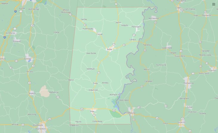
Cities and Towns in Choctaw County, Alabama

Founded in 1847, Choctaw County is the 59th biggest county by population (out of 67) in the state of Alabama. Historically, Choctaw County was formed from Sumter and Washington counties. The city of Butler is the County seat. With population density of 15.2 residents per square miles, Choctaw County has a population of 13,859 and area of 913.50 square miles.

List of all cities and towns in Choctaw County, Al

City/Town Postal Code Area Code
Bladon Springs, AL 36919 251
Bolinger, AL 36919 251
Butler, AL 36904 205/659
Gilbertown, AL 36908 251
Jachin, AL 36910 205/659
Lavaca, AL 36904 205/659
Lisman, AL 36910, 36912 205/659
Melvin, AL 36913 251
Needham, AL 36915 205/659
Pennington, AL 36916 205/659
Riderwood, AL 36904 205/659
Silas, AL 36919 251
Toxey, AL 36921 251
Ward, AL 36922 205/659
Yantley, AL 36912 205/659

Major Cities and Towns in Choctaw County, Alabama

Butler

Area, Population, and Geographic Details

  • Area: 5.6 square miles
  • Population: Approximately 1,800 (as of the latest census)
  • Zip Codes: 36904
  • Latitude: 32.0893° N
  • Longitude: 88.2209° W

Location and History

Butler is the county seat of Choctaw County, located in the southwestern part of Alabama near the Mississippi border. The town was established in 1848 and named after Colonel Pierce Butler, a prominent local figure. Butler’s history is deeply connected to the timber and railroad industries, which played significant roles in its development during the late 19th and early 20th centuries. The town served as a key hub for transporting timber, cotton, and other agricultural products, contributing to its growth and prosperity. Today, Butler remains a small, close-knit community that retains much of its historical charm, with several buildings from its early days still standing.

Major Schools and Landmarks

Butler is served by the Choctaw County School District, with Choctaw County High School and Butler Elementary School being the main educational institutions. The town is home to several notable landmarks, including the Choctaw County Courthouse, a historic building that has been the center of local government since its construction in the late 19th century. Additionally, Butler is known for the Choctaw County Historical Museum, which houses artifacts and exhibits related to the county’s history, including its Native American heritage. The nearby Bogue Chitto Creek provides opportunities for outdoor activities such as fishing and canoeing, making it a popular spot for local recreation.


Gilbertown

Area, Population, and Geographic Details

  • Area: 2.0 square miles
  • Population: Approximately 215 (as of the latest census)
  • Zip Codes: 36908
  • Latitude: 31.8790° N
  • Longitude: 88.3184° W

Location and History

Gilbertown is a small town in Choctaw County, located along Alabama State Route 17, near the state’s western border with Mississippi. The town was incorporated in 1914 and named after the Gilbert family, who were early settlers in the area. Gilbertown’s history is closely tied to the timber industry, which has been a major economic driver in the region for many years. The town has maintained a rural, agricultural character, with much of its land still dedicated to timber and farming. Despite its small size, Gilbertown has a strong sense of community and a rich cultural heritage that reflects its deep roots in the region.

Major Schools and Landmarks

Gilbertown is part of the Choctaw County School District, with students typically attending schools in nearby towns such as Silas or Butler. The town is known for its peaceful, rural setting and its proximity to outdoor recreational areas. One of the notable landmarks in Gilbertown is the historic site of the first oil well in Alabama, drilled in 1944, which marked the beginning of the state’s oil industry. The town’s annual Mule Day festival celebrates its agricultural heritage with events such as mule pulls, parades, and traditional southern foods, drawing visitors from across the region.


Silas

Area, Population, and Geographic Details

  • Area: 4.5 square miles
  • Population: Approximately 450 (as of the latest census)
  • Zip Codes: 36919
  • Latitude: 31.7665° N
  • Longitude: 88.3209° W

Location and History

Silas is a small town in the western part of Choctaw County, near the Mississippi border. The town was incorporated in 1948 and has a history rooted in agriculture and the timber industry. Silas was named after a local resident, Silas Cochran, who played a significant role in the town’s early development. The town’s economy has traditionally been based on logging and farming, with many of its residents involved in these industries. Over the years, Silas has remained a quiet, rural community, known for its friendly atmosphere and close-knit population.

Major Schools and Landmarks

Silas is served by the Choctaw County School District, with students attending Southern Choctaw High School and Silas Elementary School. The town is known for its natural beauty, with several parks and recreational areas nearby, including the Okatuppa Creek, which offers opportunities for fishing and boating. The Silas Volunteer Fire Department, housed in a historic building, is a notable landmark that serves as a focal point for the community. The town also hosts an annual Fourth of July celebration that brings together residents for fireworks, music, and family-friendly activities, highlighting Silas’s strong sense of community.

Map of Cities in Choctaw County, Al

All Cities in Choctaw County, Alabama