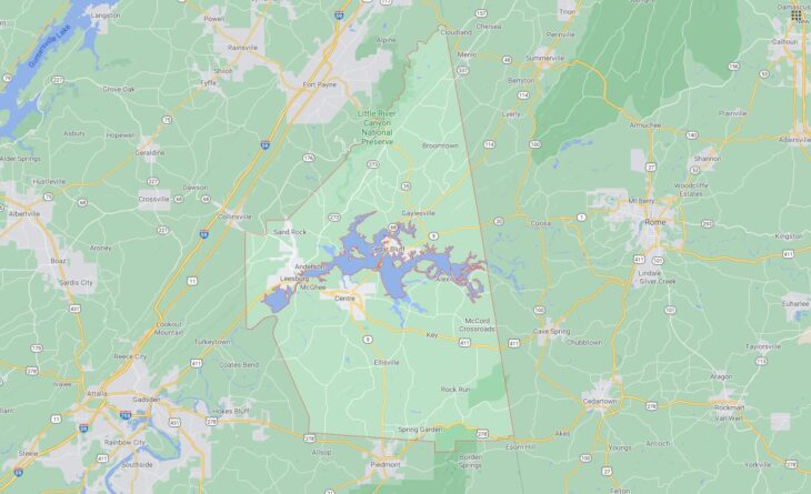
Cities and Towns in Cherokee County, Alabama
Founded in 1836, Cherokee County is the 41st biggest county by population (out of 67) in the state of Alabama. Historically, Cherokee County was formed from Cherokee territory. The city of Centre is the County seat. With population density of 46.9 residents per square miles, Cherokee County has a population of 25,989 and area of 553.70 square miles.
List of all cities and towns in Cherokee County, Al
City/Town | Postal Code | Area Code |
Cedar Bluff, AL | 35959 | 256 |
Centre, AL | 35960 | 256 |
Gaylesville, AL | 35973 | 256 |
Leesburg, AL | 35983 | 256 |
Sand Rock, AL | 35983 | 256 |
Sandrock, AL | 35983 | 256 |
Spring Garden, AL | 36275 | 256 |
Major Cities and Towns in Cherokee County, Alabama
Centre
Area, Population, and Geographic Details
- Area: 11.6 square miles
- Population: Approximately 3,500 (as of the latest census)
- Zip Codes: 35960
- Latitude: 34.1523° N
- Longitude: 85.6783° W
Location and History
Centre is the county seat of Cherokee County, Alabama, and is located in the northeastern part of the state near the Georgia border. The city was established in 1844 and named “Centre” due to its location near the geographic center of Cherokee County. Centre’s history is deeply connected to the Trail of Tears, as the area was originally inhabited by the Cherokee Nation before their forced removal in the 1830s. Over the years, Centre has developed into a hub for agriculture and commerce within the county. The construction of Weiss Lake in the 1960s brought new economic opportunities, transforming the city into a popular destination for fishing and recreation.
Major Schools and Landmarks
Centre is served by the Cherokee County School District, with Cherokee County High School being the primary educational institution in the city. The city is home to several notable landmarks, including Weiss Lake, a major attraction that offers fishing, boating, and other water-related activities. The Cherokee County Historical Museum, located in downtown Centre, showcases artifacts and exhibits related to the region’s Native American history and early settlers. Additionally, the Cherokee Rock Village, a nearby natural park, features unique rock formations and offers hiking, rock climbing, and stunning views of the surrounding area.
Cedar Bluff
Area, Population, and Geographic Details
- Area: 5.3 square miles
- Population: Approximately 1,800 (as of the latest census)
- Zip Codes: 35959
- Latitude: 34.2257° N
- Longitude: 85.5947° W
Location and History
Cedar Bluff is a small town located in northeastern Cherokee County, along the shores of Weiss Lake. The town was incorporated in 1837 and named after the cedar trees that were abundant in the area. Cedar Bluff has a rich history tied to the Civil War, with several skirmishes and troop movements occurring in and around the town. The town’s proximity to the Coosa River, which was dammed to create Weiss Lake, has made it a focal point for fishing and outdoor recreation in the region. Cedar Bluff has maintained its small-town charm while benefiting from the tourism and recreational activities associated with the lake.
Major Schools and Landmarks
Cedar Bluff is served by the Cherokee County School District, with Cedar Bluff School providing education from kindergarten through 12th grade. The town is known for its picturesque location on Weiss Lake, which is renowned for its crappie fishing and attracts anglers from across the country. The town also features historical sites such as the Cornwall Furnace, a Civil War-era iron furnace that is now preserved as a historical park. Additionally, Cedar Bluff hosts an annual Crappie Rodeo, a fishing tournament that celebrates the town’s reputation as a top fishing destination.
Leesburg
Area, Population, and Geographic Details
- Area: 6.0 square miles
- Population: Approximately 1,000 (as of the latest census)
- Zip Codes: 35983
- Latitude: 34.1785° N
- Longitude: 85.7666° W
Location and History
Leesburg is a small town located in the western part of Cherokee County, near the base of Lookout Mountain. The town was incorporated in 1958, though the area has a history that dates back much further, with early settlers arriving in the early 19th century. Leesburg’s location along Alabama State Route 68 has made it a key access point for travelers heading to the mountain and nearby natural attractions. The town’s history is closely tied to agriculture, with farming being the primary industry for many years. In recent decades, Leesburg has become increasingly popular as a gateway to outdoor activities in the surrounding area.
Major Schools and Landmarks
Leesburg is part of the Cherokee County School District, with students attending nearby schools in Centre and Sand Rock. The town is known for its proximity to Little River Canyon National Preserve, one of Alabama’s most scenic natural areas, offering hiking, swimming, and breathtaking views of the canyon. Leesburg Landing on Weiss Lake provides access to boating and fishing, making it a popular spot for locals and visitors alike. Additionally, the Cherokee Rock Village, located just outside Leesburg, is a well-known site for rock climbing and offers panoramic views of the valley below.