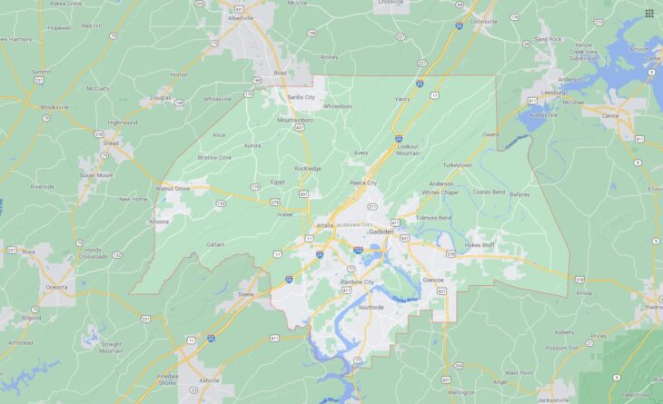
Cities and Towns in Etowah County, Alabama

Founded in 1866, Etowah County is the 11th biggest county by population (out of 67) in the state of Alabama. Historically, Etowah County was formed from Blount, Calhoun, Cherokee, DeKalb, Marshall, and St. Clair counties (as Baine County). The city of Gadsden is the County seat. With population density of 195.2 residents per square miles, Etowah County has a population of 104,430 and area of 534.99 square miles.

List of all cities and towns in Etowah County, Al

City/Town Postal Code Area Code
Altoona, AL 35952 205/659
Attalla, AL 35954 256
Boaz, AL 35956 256
East Gadsden, AL 35903 256
Gadsden, AL 35901, 35902, 35903, 35904, 35905, 35906, 35907 256
Gallant, AL 35972 256
Glencoe, AL 35905 256
Hokes Bluff, AL 35903 256
Ivalee, AL 35954 256
Rainbow City, AL 35906 256
Rbc, AL 35906 256
Reece City, AL 35954 256
Ridgeville, AL 35954 256
Rockledge, AL 35954 256
Sardis City, AL 35956 256
Snead, AL 35952 205/659
Southside, AL 35907 256
Walnut Grove, AL 35990 205/659

Major Cities and Towns in Etowah County, Alabama

Gadsden

Area, Population, and Geographic Details

  • Area: 38.3 square miles
  • Population: Approximately 35,000 (as of the latest census)
  • Zip Codes: 35901, 35903, 35904, 35907
  • Latitude: 34.0143° N
  • Longitude: 86.0066° W

Location and History

Gadsden is the county seat of Etowah County and is located in northeastern Alabama along the Coosa River. The city was incorporated in 1847 and named after James Gadsden, a U.S. diplomat who played a significant role in the Gadsden Purchase. Gadsden grew rapidly in the late 19th and early 20th centuries due to its strategic location along the river, which made it a key transportation hub for the region. The city became an industrial powerhouse, particularly in steel production, which shaped its economy and development for much of the 20th century. Although the steel industry has declined, Gadsden has diversified its economy and remains an important commercial and cultural center in northeastern Alabama.

Major Schools and Landmarks

Gadsden is served by the Gadsden City Schools system, with Gadsden City High School and Emma Sansom Middle School being the primary educational institutions. The city is home to several significant landmarks, including Noccalula Falls Park, which features a stunning 90-foot waterfall, botanical gardens, and a pioneer village. The Gadsden Museum of Art offers exhibits on local history, culture, and contemporary art, while the Mary G. Hardin Center for Cultural Arts hosts a variety of performances and events. The annual Riverfest music festival is a major attraction, drawing visitors from across the region to enjoy live music, food, and activities along the Coosa River.


Attalla

Area, Population, and Geographic Details

  • Area: 7.0 square miles
  • Population: Approximately 5,900 (as of the latest census)
  • Zip Codes: 35954
  • Latitude: 34.0190° N
  • Longitude: 86.1005° W

Location and History

Attalla is a city in Etowah County, located just west of Gadsden. The city was incorporated in 1870 and has a rich history tied to the railroad and industrial development. Attalla was originally a major hub for the Louisville and Nashville Railroad, which played a crucial role in the city’s growth during the late 19th century. The city also became known for its coal mines, which contributed to its economic development. Attalla’s downtown area retains much of its historic charm, with several buildings from the early 20th century still standing, reflecting its industrial past.

Major Schools and Landmarks

Attalla is served by the Attalla City Schools system, with Etowah High School and Etowah Middle School being the main educational institutions. The city is home to several notable landmarks, including the Wills Creek Winery, which offers tours and tastings of locally produced wines. The historic Attalla Depot, now a museum, showcases the city’s railroad history and its role in the development of the region. The annual Attalla Heritage Day celebrates the city’s history and community spirit with parades, music, and family-friendly activities, attracting residents and visitors alike.


Rainbow City

Area, Population, and Geographic Details

  • Area: 25.0 square miles
  • Population: Approximately 9,700 (as of the latest census)
  • Zip Codes: 35906
  • Latitude: 33.9523° N
  • Longitude: 86.0786° W

Location and History

Rainbow City is a city located in the southern part of Etowah County, just south of Gadsden. The city was incorporated in 1950 and has experienced significant growth over the past several decades due to its proximity to Gadsden and its location along U.S. Highway 411. Rainbow City was named after the Rainbow Division, a unit of the U.S. Army National Guard that served in World War I. The city has developed into a thriving residential community with a strong focus on family life, education, and recreation.

Major Schools and Landmarks

Rainbow City is served by the Etowah County School District, with Southside High School and Rainbow Middle School being the primary educational institutions. The city is home to several parks and recreational facilities, including Vivian Lee Maddox Sports Complex, which offers sports fields, walking trails, and picnic areas. Another key attraction is the Rainbow City Public Library, which serves as a cultural and educational hub for the community. The city hosts various community events throughout the year, including the annual Christmas parade and the Liberty Day celebration, which brings residents together to celebrate their shared values and community spirit.


Southside

Area, Population, and Geographic Details

  • Area: 19.5 square miles
  • Population: Approximately 8,400 (as of the latest census)
  • Zip Codes: 35907
  • Latitude: 33.9243° N
  • Longitude: 86.0319° W

Location and History

Southside is a city in Etowah County, located along the banks of the Coosa River, just south of Gadsden. The city was incorporated in 1957 and has grown steadily as a suburban community, attracting residents who work in Gadsden and other nearby cities. Southside’s history is closely tied to its location along the river, which has provided opportunities for recreation, transportation, and commerce. The city has developed a reputation as a family-friendly community with a strong emphasis on education and quality of life.

Major Schools and Landmarks

Southside is served by the Etowah County School District, with Southside High School and Rainbow Middle School being the primary educational institutions. The city is known for its scenic views of the Coosa River, which offers opportunities for boating, fishing, and other water-based activities. Southside’s parks, including the Southside Park and City Hall Park, provide recreational spaces for residents and visitors to enjoy. The city’s annual Fourth of July celebration, featuring fireworks and live music, is a highlight of the year, drawing families and visitors to celebrate the holiday along the river.

Map of Cities in Etowah County, Al

All Cities in Etowah County, Alabama