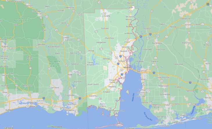
Cities and Towns in Mobile County, Alabama

Founded in 1812, Mobile County is the 2nd biggest county by population (out of 67) in the state of Alabama. Historically, Mobile County was formed from Mobile District of West Florida after annexation into Mississippi Territory. The city of Mobile is the County seat. With population density of 336.04 residents per square miles, Mobile County has a population of 412,992 and area of 1,229.44 square miles.

List of all cities and towns in Mobile County, Al

City/Town Postal Code Area Code
Alabama Port, AL 36523 251
Axis, AL 36505 251
Bayou Labatre, AL 36509 251
Brookley Field, AL 36615 251
Bucks, AL 36512 251
Chastang, AL 36560 251
Chickasaw, AL 36611, 36671 251
Chunchula, AL 36521 251
Citronelle, AL 36522 251
Coden, AL 36523 251
Creola, AL 36525 251
Dauphin Island, AL 36528 251
Eight Mile, AL 36613, 36663 251
Fellowship, AL 36521 251
Georgetown, AL 36521 251
Grand Bay, AL 36541 251
Gulf Crest, AL 36521 251
Heron Bay, AL 36523 251
Irvington, AL 36544 251
Lemoyne, AL 36505 251
Magazine, AL 36610 251
Mobile, AL 36601, 36602, 36603, 36604, 36605, 36606, 36607, 36608, 36609, 36610, 36611, 36612, 36613, 36615, 36616, 36617, 36618, 36619, 36625, 36628, 36630, 36633, 36640, 36641, 36644, 36652, 36660, 36663, 36670, 36671, 36675, 36685, 36688, 36689, 36691, 36693, 36695 251
Mobile Gov Plz, AL 36644 251
Mobile P&DC, AL 36675 251
Mon Louis, AL 36523 251
Morrisons Cafeteria, AL 36625 251
Mount Vernon, AL 36560 251
Press Register Inc, AL 36630 251
Prichard, AL 36610, 36613, 36617 251
Saint Elmo, AL 36568 251
Saltaire, AL 36582 251
Saraland, AL 36571 251
Satsuma, AL 36572 251
Semmes, AL 36575 251
Theodore, AL 36582, 36590, 36619 251
Turnerville, AL 36521 251
U S Corps of Engineers, AL 36628 251
University of South Alabama, AL 36688 251
Whistler, AL 36612, 36587 251

Major Cities and Towns in Mobile County, Alabama

Mobile

Area, Population, Zip Codes, Latitude, and Longitude

  • Area: 180.1 square miles
  • Population: 187,041 (as of the 2020 census)
  • Zip Codes: 36601-36619, 36621-36628, 36633, 36640, 36644, 36652, 36660, 36663, 36670, 36671, 36675, 36685, 36688, 36689, 36690, 36691, 36693, 36695
  • Latitude: 30.6954° N
  • Longitude: 88.0399° W

Location and History

Mobile is the county seat and largest city in Mobile County, located on the Gulf Coast of Alabama. Founded in 1702 by French settlers, Mobile is one of the oldest cities in the United States, with a rich history as a major port and cultural center. The city has been under the control of various powers, including the French, British, Spanish, and eventually the United States. Mobile played significant roles during the Civil War and World War II, and its port remains one of the busiest in the nation. The city is known for its unique blend of French, Spanish, British, Creole, and African cultures, making it a vibrant and diverse community. Mobile is also famous for having the oldest organized Carnival (Mardi Gras) celebrations in the United States, which began in the early 1700s.

Major Schools and Landmarks

Mobile is served by the Mobile County Public School System, with major schools including Murphy High School, Baker High School, and Davidson High School. The city is home to several higher education institutions, including the University of South Alabama and Spring Hill College. Significant landmarks in Mobile include the USS Alabama Battleship Memorial Park, which honors veterans and features the battleship USS Alabama and the submarine USS Drum. The historic district of downtown Mobile boasts numerous antebellum homes, museums, and the Cathedral Basilica of the Immaculate Conception. The GulfQuest National Maritime Museum and the Mobile Carnival Museum highlight the city’s maritime history and its unique Carnival traditions. Mobile’s annual events, such as the Mardi Gras parades and the BayFest music festival, draw visitors from around the world. The combination of historical significance, educational institutions, and cultural vibrancy makes Mobile a central and dynamic part of Alabama’s Gulf Coast region.

Prichard

Area, Population, Zip Codes, Latitude, and Longitude

  • Area: 25.4 square miles
  • Population: 19,322 (as of the 2020 census)
  • Zip Codes: 36610, 36611, 36612, 36613, 36617
  • Latitude: 30.7385° N
  • Longitude: 88.0798° W

Location and History

Prichard is a city located in the northern part of Mobile County, adjacent to the city of Mobile. Prichard was incorporated in 1925 and grew rapidly as an industrial and residential suburb of Mobile, driven by the expansion of the shipbuilding and steel industries during the early 20th century. The city was named after Cleveland Prichard, a local landowner who played a key role in its development. Prichard’s growth was tied closely to its proximity to Mobile and the economic opportunities provided by the industrial sector. However, the decline of these industries in the latter half of the 20th century led to economic challenges for the city. Despite these challenges, Prichard has maintained a strong sense of community and continues to be an important part of Mobile County.

Major Schools and Landmarks

Prichard is served by the Mobile County Public School System, with major schools including Vigor High School, Blount High School, and Prichard Preparatory School. The city is home to several historic landmarks, including the Prichard Municipal Building, which reflects the city’s early 20th-century growth. The Africatown Historic District, located near Prichard, is a significant site that preserves the history of one of the last groups of enslaved Africans brought to the United States. The nearby Chickasabogue Park offers opportunities for outdoor recreation, including fishing, boating, and picnicking, and is a popular destination for residents. Prichard’s annual events, such as the Mardi Gras parades and community festivals, celebrate the city’s cultural heritage and bring residents together. The combination of historical significance, educational institutions, and community spirit makes Prichard an integral part of Mobile County.

Saraland

Area, Population, Zip Codes, Latitude, and Longitude

  • Area: 32.6 square miles
  • Population: 15,486 (as of the 2020 census)
  • Zip Codes: 36571
  • Latitude: 30.8208° N
  • Longitude: 88.0706° W

Location and History

Saraland is a city located in the northern part of Mobile County, just north of Prichard. The city was incorporated in 1957 and has since grown into a thriving suburban community. Saraland’s development was spurred by its proximity to Mobile and the construction of Interstate 65, which provided easy access to the larger city and other parts of the state. The city’s name is believed to be derived from “Sara,” the wife of the landowner who donated the land for the first railroad station in the area. Saraland has become known for its strong school system, family-friendly neighborhoods, and growing commercial sector.

Major Schools and Landmarks

Saraland is served by the Saraland City School System, which is known for its high-performing schools, including Saraland High School, Saraland Middle School, and Saraland Elementary School. The city is home to several parks and recreational facilities, including Amelia Park and Saraland Civic Center, which host community events and sports activities. The nearby Mobile-Tensaw River Delta offers opportunities for boating, fishing, and exploring Alabama’s natural beauty. Saraland’s annual events, such as the Saraland Mardi Gras Parade and the Christmas on the Hill festival, bring the community together and celebrate the city’s growth and community spirit. The combination of excellent schools, suburban convenience, and a strong sense of community makes Saraland an important and vibrant part of Mobile County.

Satsuma

Area, Population, Zip Codes, Latitude, and Longitude

  • Area: 7.5 square miles
  • Population: 6,749 (as of the 2020 census)
  • Zip Codes: 36572
  • Latitude: 30.8549° N
  • Longitude: 88.0650° W

Location and History

Satsuma is a small city located in the northern part of Mobile County, just north of Saraland. The city was incorporated in 1959 and was named after the Satsuma orange, a type of citrus fruit that was introduced to the area in the early 20th century. The city’s early economy was based on agriculture, particularly citrus farming, but it has since evolved into a suburban community with a focus on residential development and quality of life. Satsuma has maintained its small-town charm while benefiting from its proximity to larger cities like Mobile and Saraland.

Major Schools and Landmarks

Satsuma is served by the Satsuma City Schools system, with major schools including Satsuma High School and Robert E. Lee Elementary School. The city is home to several parks and recreational facilities, including Wright Park and Baldwin Square, which offer spaces for sports, picnics, and community events. The historic Baldwin County Courthouse, although no longer in use, remains a significant landmark in the city. Satsuma’s annual events, such as the Satsuma Christmas Parade and Satsuma Heritage Day, bring the community together and celebrate the town’s heritage and traditions. The combination of excellent schools, suburban amenities, and a strong sense of community makes Satsuma a key city in Mobile County.

Bayou La Batre

Area, Population, Zip Codes, Latitude, and Longitude

  • Area: 7.3 square miles
  • Population: 2,204 (as of the 2020 census)
  • Zip Codes: 36509
  • Latitude: 30.4038° N
  • Longitude: 88.2486° W

Location and History

Bayou La Batre is a small city located in the southern part of Mobile County, along the Gulf Coast. The city was founded in 1786 by French settlers and has a long history as a fishing and shipbuilding community. Bayou La Batre is often referred to as the “Seafood Capital of Alabama,” and its economy has historically been centered around the seafood industry, including shrimping, fishing, and oyster harvesting. The city gained national recognition as the setting for several scenes in the movie Forrest Gump. Bayou La Batre’s rich cultural heritage reflects a blend of French, Creole, Vietnamese, and other influences.

Major Schools and Landmarks

Bayou La Batre is served by the Mobile County Public School System, with major schools including Alma Bryant High School and Anna F. Booth Elementary School. The city is home to several historic landmarks, including the Bayou La Batre City Hall, which reflects the city’s long history as a fishing village. The nearby Bayou La Batre waterfront is a key area for the local seafood industry, with docks, seafood processing plants, and shipyards lining the bayou. The city’s annual Blessing of the Fleet festival celebrates the local seafood industry and maritime heritage, drawing visitors from across the region. The combination of a rich cultural history, a strong connection to the seafood industry, and a close-knit community makes Bayou La Batre an important and unique part of Mobile County.

Citronelle

Area, Population, Zip Codes, Latitude, and Longitude

  • Area: 25.2 square miles
  • Population: 3,946 (as of the 2020 census)
  • Zip Codes: 36522
  • Latitude: 31.0957° N
  • Longitude: 88.2289° W

Location and History

Citronelle is a small city located in the northern part of Mobile County, near the border with Washington County. The city was incorporated in 1892 and is named after the citronella plant, which grows abundantly in the area. Citronelle’s early development was closely tied to the timber and mineral industries, with the discovery of oil in the area during the early 20th century bringing a period of rapid growth. The city is known for its natural springs, which were once believed to have medicinal properties, attracting visitors seeking health benefits. Today, Citronelle is a quiet, rural community with a focus on outdoor recreation and a connection to the natural environment.

Major Schools and Landmarks

Citronelle is served by the Mobile County Public School System, with major schools including Citronelle High School and McDavid-Jones Elementary School. The city is home to several notable landmarks, including the Citronelle Depot Museum, which preserves the history of the city and the role of the railroad in its development. The nearby Citronelle Lake offers opportunities for fishing, boating, and picnicking, and is a popular destination for residents and visitors alike. Citronelle’s annual events, such as the Citronelle Heritage Festival, celebrate the city’s history and bring the community together. The combination of historical significance, natural beauty, and a strong sense of community makes Citronelle a valued part of Mobile County.

Map of Cities in Mobile County, Al

All Cities in Mobile County, Alabama