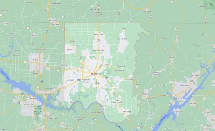
Cities and Towns in Madison County, Alabama
Founded in 1808, Madison County is the 3rd biggest county by population (out of 67) in the state of Alabama. Historically, Madison County was formed from Cherokee and Chickasaw territories. The city of Huntsville is the County seat. With population density of 417.47 residents per square miles, Madison County has a population of 334,811 and area of 801.59 square miles.
List of all cities and towns in Madison County, Al
City/Town | Postal Code | Area Code |
Alabama A and M, AL | 35762 | 256 |
Big Cove, AL | 35763 | 256 |
Brownsboro, AL | 35741 | 256 |
Gurley, AL | 35748 | 256 |
Hampton Cove, AL | 35763 | 256 |
Harvest, AL | 35749 | 256 |
Hazel Green, AL | 35750 | 256 |
Huntsville, AL | 35801, 35802, 35803, 35804, 35805, 35806, 35807, 35808, 35809, 35810, 35811, 35812, 35813, 35814, 35815, 35816, 35824, 35893, 35894, 35895, 35896, 35897, 35898, 35899 | 256 |
Huntsville Utilities, AL | 35895 | 256 |
Intergraph Corporation, AL | 35894 | 256 |
Madison, AL | 35757, 35758 | 256 |
Meridianville, AL | 35759 | 256 |
Munitions Missle Com Sch, AL | 35897 | 256 |
New Hope, AL | 35760 | 256 |
New Market, AL | 35761 | 256 |
Normal, AL | 35762 | 256 |
Oakwood College, AL | 35896 | 256 |
Owens Crossroads, AL | 35763 | 256 |
Owens X Roads, AL | 35763 | 256 |
Redstone Arsenal, AL | 35808, 35809 | 256 |
Redstone Central, AL | 35898 | 256 |
Redstone Fed Credit Union, AL | 35893 | 256 |
Ryland, AL | 35767 | 256 |
Toney, AL | 35773 | 256 |
Triana, AL | 35758 | 256 |
University of Alabama Hsv, AL | 35899 | 256 |
Major Cities and Towns in Madison County, Alabama
Huntsville
Area, Population, Zip Codes, Latitude, and Longitude
- Area: 218.9 square miles
- Population: 215,006 (as of the 2020 census)
- Zip Codes: 35801-35816, 35824, 35893-35899
- Latitude: 34.7304° N
- Longitude: 86.5861° W
Location and History
Huntsville is the largest city in Madison County and serves as the county seat. Located in the northern part of Alabama, Huntsville was founded in 1805 by John Hunt and quickly became a prominent center for cotton trading in the early 19th century. The city is often referred to as “Rocket City” due to its pivotal role in the U.S. space program. The establishment of Redstone Arsenal and NASA’s Marshall Space Flight Center in the mid-20th century transformed Huntsville into a hub for aerospace and defense industries. Today, Huntsville is known for its strong economy, driven by technology, research, and manufacturing, as well as its cultural and historical significance.
Major Schools and Landmarks
Huntsville is served by the Huntsville City Schools system, with major schools including Huntsville High School, Grissom High School, and Lee High School. The city is also home to several higher education institutions, including the University of Alabama in Huntsville and Alabama A&M University. Significant landmarks include the U.S. Space & Rocket Center, which showcases the city’s role in space exploration and is one of Alabama’s top tourist attractions. The historic Twickenham district features well-preserved antebellum homes, while Big Spring International Park is a central location for festivals and community events. Huntsville’s annual events, such as the Panoply Arts Festival and the Rocket City Marathon, celebrate the city’s vibrant arts and culture scene. The combination of historical significance, educational institutions, and technological innovation makes Huntsville a dynamic and central part of Madison County.
Madison
Area, Population, Zip Codes, Latitude, and Longitude
- Area: 29.7 square miles
- Population: 56,933 (as of the 2020 census)
- Zip Codes: 35756-35758
- Latitude: 34.6993° N
- Longitude: 86.7483° W
Location and History
Madison is a rapidly growing city located west of Huntsville in Madison County. Originally a small railroad town established in 1869, Madison has experienced significant growth in recent decades, driven by its proximity to Huntsville and the expansion of the aerospace and defense industries. The city was named after James Madison, the fourth President of the United States, and developed as a hub for agriculture and trade in its early years. Madison has evolved into a suburban community with a strong emphasis on education, family life, and quality of living, making it one of the most desirable places to live in Alabama.
Major Schools and Landmarks
Madison is served by the Madison City Schools system, known for its high-performing schools, including Bob Jones High School, James Clemens High School, and Discovery Middle School. The city is home to several parks and recreational facilities, such as Dublin Park, which offers sports fields, walking trails, and a community pool. Historic Downtown Madison features a mix of shops, restaurants, and historic buildings that reflect the city’s railroad heritage. Madison’s annual events, including the Madison Street Festival and Christmas Parade, bring the community together and celebrate the city’s vibrant culture and history. The combination of excellent schools, suburban amenities, and a strong sense of community makes Madison an important and growing part of Madison County.
New Hope
Area, Population, Zip Codes, Latitude, and Longitude
- Area: 8.9 square miles
- Population: 2,889 (as of the 2020 census)
- Zip Codes: 35760
- Latitude: 34.5379° N
- Longitude: 86.4119° W
Location and History
New Hope is a small town located in the southeastern part of Madison County, near the Tennessee River. The town was originally known as Vienna but was renamed New Hope after the Civil War, in honor of a Methodist church that had been a central part of the community. New Hope developed as a rural farming community, with cotton being the primary crop in its early years. Over time, the town has maintained its small-town charm and rural character, while also benefiting from its proximity to Huntsville, which has provided economic opportunities and access to urban amenities.
Major Schools and Landmarks
New Hope is served by the Madison County School District, with major schools including New Hope High School, New Hope Elementary School, and New Hope Middle School. The town is home to several historic landmarks, including the New Hope Methodist Church, which dates back to the 19th century and remains a focal point of the community. The nearby Lake Guntersville offers opportunities for fishing, boating, and enjoying the natural beauty of the area. New Hope’s annual events, such as the Founders Day Festival and the Christmas Parade, bring residents together and celebrate the town’s heritage and community spirit. The town’s small size, historical significance, and close-knit community make New Hope a valued part of Madison County.
Hazel Green
Area, Population, Zip Codes, Latitude, and Longitude
- Area: 9.9 square miles
- Population: 4,191 (as of the 2020 census)
- Zip Codes: 35750
- Latitude: 34.9331° N
- Longitude: 86.5714° W
Location and History
Hazel Green is an unincorporated community located in the northern part of Madison County, near the Alabama-Tennessee border. The community was named after the green hazel trees that grew in the area when it was first settled in the early 19th century. Hazel Green developed as a small agricultural community, with cotton and other crops being the primary industries. The community has retained its rural character over the years, while also experiencing growth due to its proximity to Huntsville and the expansion of suburban development in the region.
Major Schools and Landmarks
Hazel Green is served by the Madison County School District, with major schools including Hazel Green High School, Hazel Green Elementary School, and Meridianville Middle School. The community is home to several historic churches and cemeteries that reflect its long history. The surrounding countryside offers opportunities for outdoor activities such as hunting, fishing, and farming, which are integral to the local way of life. Hazel Green’s annual events, including the Hazel Green Christmas Parade and local fairs, bring the community together and celebrate the town’s rural heritage and strong community ties. The combination of historical significance, rural charm, and community spirit makes Hazel Green an important part of Madison County.
Gurley
Area, Population, Zip Codes, Latitude, and Longitude
- Area: 3.5 square miles
- Population: 816 (as of the 2020 census)
- Zip Codes: 35748
- Latitude: 34.7000° N
- Longitude: 86.3728° W
Location and History
Gurley is a small town located in the eastern part of Madison County, near the foothills of the Appalachian Mountains. The town was established in 1868 and named after John Gurley, a local farmer who donated land for the construction of a railroad depot. Gurley grew as a railroad town, with the depot serving as a key stop along the Memphis and Charleston Railroad. The town developed as a small farming community, with the railroad providing a means to transport goods to larger markets. Despite its small size, Gurley has a rich history and has maintained its rural character and close-knit community.
Major Schools and Landmarks
Gurley is served by the Madison County School District, with major schools including Madison County Elementary School and Madison County High School. The town is home to several historic buildings, including the Gurley Historic Depot, which now serves as a museum and community center. The nearby Monte Sano State Park offers opportunities for hiking, camping, and enjoying the scenic beauty of the Appalachian foothills. Gurley’s annual events, such as the Gurley Christmas Parade and community fairs, bring residents together and celebrate the town’s heritage and community spirit. The town’s small size, historical significance, and close-knit community make Gurley an important part of Madison County.
Triana
Area, Population, Zip Codes, Latitude, and Longitude
- Area: 2.3 square miles
- Population: 529 (as of the 2020 census)
- Zip Codes: 35756
- Latitude: 34.5906° N
- Longitude: 86.7494° W
Location and History
Triana is a small town located in the southwestern part of Madison County, along the banks of the Tennessee River. The town was founded in the early 19th century and was once a thriving port and trade center due to its strategic location on the river. Triana was named after Rodrigo de Triana, a crew member of Christopher Columbus’s expedition who was the first to sight land in the New World. The town experienced economic decline in the late 19th and early 20th centuries as river traffic decreased, but it has retained its historical significance and unique cultural heritage.
Major Schools and Landmarks
Triana is served by the Madison County School District, with students typically attending schools in nearby communities such as Madison. The town is home to several historic sites, including the Triana Historic District, which features buildings and landmarks that reflect the town’s history as a river port. The nearby Wheeler National Wildlife Refuge offers opportunities for birdwatching, fishing, and exploring the natural beauty of the Tennessee River Valley. Triana’s annual events, such as the Triana Heritage Festival, celebrate the town’s rich history and bring the community together. The combination of historical significance, natural beauty, and close-knit community makes Triana an important and unique part of Madison County.