Arkansas Counties List

There are a total of 75 counties in the state of Arkansas. Among them, Arkansas County is the oldest one (established in 1813) while Cleburne County is the youngest (established in 1883).  With population of 382,748, Pulaski County is the most populated. The biggest county by land area is Union County (2,733 km²) and the smallest is Lafayette County (1,412 km²).

Largest Counties in Arkansas

1. Union County

County Seat: El Dorado

  • Area: 1,039 square miles
  • Population: Approximately 38,682 (2020 census)
  • Area Codes: 870
  • Latitude: 33.2076° N
  • Longitude: 92.6622° W

Location and History

Union County is located in the southern part of Arkansas, bordering Louisiana. Established on November 2, 1829, it was named to reflect the spirit of unity during a period of national division. El Dorado, the county seat, became prominent in the 1920s during the South Arkansas oil boom, transforming the town into a bustling economic center almost overnight. This period of rapid growth shaped much of the county’s history and development, leaving a legacy of wealth and architectural heritage that can still be seen today. The county’s economy has traditionally been based on oil, timber, and agriculture.

Major Highways and Landmarks

Union County is served by several major highways, including U.S. Highways 63 and 82, which provide critical connections to other parts of Arkansas and Louisiana. Notable landmarks include the Arkansas Museum of Natural Resources, which explores the history of the oil boom in the region, and the South Arkansas Arboretum, offering a variety of native plant species. The Murphy Arts District in El Dorado has revitalized the downtown area, making it a cultural hub for music, art, and entertainment. The historic El Dorado Downtown District, with its well-preserved architecture, is another significant attraction.

2. Pulaski County

County Seat: Little Rock

  • Area: 808 square miles
  • Population: Approximately 399,125 (2020 census)
  • Area Codes: 501
  • Latitude: 34.7465° N
  • Longitude: 92.2896° W

Location and History

Pulaski County is located in central Arkansas and is home to Little Rock, the state capital and largest city. Established on December 15, 1818, it is named after Count Casimir Pulaski, a Polish nobleman and Revolutionary War hero. Little Rock’s central location on the Arkansas River made it a key site for early settlement, trade, and governance in the state. The county played a crucial role during the Civil Rights Movement, particularly with the 1957 Little Rock Central High School integration crisis, which became a pivotal moment in American history.

Major Highways and Landmarks

Pulaski County is a major transportation hub, intersected by Interstates 30, 40, 430, and 440, as well as U.S. Highways 67, 70, and 167. Key landmarks include the Arkansas State Capitol, a historic and political centerpiece of the state, and the William J. Clinton Presidential Library, which showcases the legacy of the 42nd President of the United States. The county is also home to the Little Rock Central High School National Historic Site, preserving the history of the 1957 integration crisis. The River Market District in downtown Little Rock offers a vibrant mix of dining, entertainment, and cultural attractions.

3. Clark County

County Seat: Arkadelphia

  • Area: 883 square miles
  • Population: Approximately 22,995 (2020 census)
  • Area Codes: 870
  • Latitude: 34.1206° N
  • Longitude: 93.0538° W

Location and History

Clark County is located in southwestern Arkansas, nestled between the Ouachita Mountains and the Arkansas Timberlands. Established on December 15, 1818, it is one of the oldest counties in Arkansas and was named after William Clark of the Lewis and Clark Expedition. The county seat, Arkadelphia, developed as an educational and agricultural center, with the founding of two universities: Henderson State University and Ouachita Baptist University. The county’s history is marked by its role in the timber and railroad industries, which drove much of its early economic growth.

Major Highways and Landmarks

Clark County is accessible via Interstate 30, which connects it to Little Rock and Texarkana, and U.S. Highways 67 and 70. Significant landmarks include DeGray Lake Resort State Park, offering outdoor recreation opportunities such as fishing, boating, and golf. The historic downtown Arkadelphia is home to several well-preserved buildings, reflecting the town’s rich history. The Ouachita Mountains provide a scenic backdrop to the county, with opportunities for hiking, camping, and exploring the natural beauty of the region. Additionally, the Clark County Historical Museum in Arkadelphia offers insights into the county’s past.

4. Jefferson County

County Seat: Pine Bluff

  • Area: 914 square miles
  • Population: Approximately 67,260 (2020 census)
  • Area Codes: 870
  • Latitude: 34.2284° N
  • Longitude: 92.0032° W

Location and History

Jefferson County is located in the southeastern part of Arkansas, along the Arkansas River. Established on November 2, 1829, it was named after Thomas Jefferson, the third President of the United States. Pine Bluff, the county seat, grew rapidly in the 19th century as a center for cotton production and trade, supported by its location on the river. The county’s economy has historically been based on agriculture, particularly cotton, soybeans, and rice, though it has diversified over time to include manufacturing and services. Pine Bluff also played a significant role during the Civil Rights Movement, with several notable protests and legal battles occurring in the area.

Major Highways and Landmarks

Jefferson County is intersected by major highways, including Interstate 530, which connects Pine Bluff to Little Rock, and U.S. Highways 63, 65, 79, and 425. Key landmarks include the Arkansas Entertainers Hall of Fame, which celebrates the contributions of Arkansans to the entertainment industry, and the Delta Rivers Nature Center, which highlights the natural beauty and wildlife of the Arkansas Delta. The historic downtown Pine Bluff features several well-preserved buildings, including the Jefferson County Courthouse. The Pine Bluff Arsenal, a major military installation, has been a significant part of the county’s economy since World War II.

5. White County

County Seat: Searcy

  • Area: 1,042 square miles
  • Population: Approximately 77,123 (2020 census)
  • Area Codes: 501
  • Latitude: 35.2468° N
  • Longitude: 91.7337° W

Location and History

White County is located in central Arkansas, northeast of Little Rock. It was established on October 23, 1835, and named after Hugh Lawson White, a prominent U.S. Senator from Tennessee. Searcy, the county seat, developed as a commercial and educational center, particularly with the founding of Harding University in the early 20th century. The county’s history is rooted in agriculture, with cotton, soybeans, and livestock being key components of its economy. The discovery of oil in the mid-20th century further diversified the county’s economic base.

Major Highways and Landmarks

White County is accessible via U.S. Highways 67 and 167, which run through Searcy and provide connections to Little Rock and the northern parts of the state. Notable landmarks include the Pioneer Village in Searcy, a living history museum that preserves the region’s early settler history. The White County Courthouse, an architectural gem, stands as a symbol of the county’s history. The Little Red River, famous for its trout fishing, is another key attraction in the county. The annual White County Fair, one of the largest in Arkansas, celebrates the county’s agricultural heritage.

6. Craighead County

County Seat: Jonesboro

  • Area: 713 square miles
  • Population: Approximately 111,231 (2020 census)
  • Area Codes: 870
  • Latitude: 35.8423° N
  • Longitude: 90.7043° W

Location and History

Craighead County is located in northeastern Arkansas, in the Arkansas Delta region. It was established on February 19, 1859, and named after state Senator Thomas Craighead. The county seat, Jonesboro, is one of the largest cities in Arkansas and a significant hub for education, commerce, and healthcare in the region. Arkansas State University, located in Jonesboro, plays a central role in the county’s cultural and economic life. The county’s history is tied to agriculture, particularly cotton, rice, and soybeans, but it has diversified into manufacturing and services over the years.

Major Highways and Landmarks

Craighead County is served by U.S. Highways 49, 63, and 67, which provide vital connections within the state and beyond. Significant landmarks include the Crowley’s Ridge Nature Center, which offers educational exhibits and outdoor activities related to the unique geological formation of Crowley’s Ridge. The Craighead Forest Park in Jonesboro is a popular recreational area featuring trails, fishing, and picnic spots. The county also hosts the annual Arkansas State University Homecoming, which brings together students, alumni, and the community for a celebration of school spirit and local culture.

7. Phillips County

County Seat: Helena-West Helena

  • Area: 727 square miles
  • Population: Approximately 16,568 (2020 census)
  • Area Codes: 870
  • Latitude: 34.5294° N
  • Longitude: 90.5912° W

Location and History

Phillips County is located in the eastern part of Arkansas, along the Mississippi River. Established on May 1, 1820, it is one of the oldest counties in the state and was named after Sylvanus Phillips, an early settler and prominent landowner. The county seat, Helena-West Helena, played a crucial role during the Civil War as a strategic location along the Mississippi River. The region’s history is deeply rooted in agriculture, particularly cotton, which has shaped the county’s economy and culture. Phillips County is also known for its significant contributions to the Delta blues music genre.

Major Highways and Landmarks

Phillips County is accessible via U.S. Highways 49 and 61, which provide connections to Memphis, Tennessee, and other parts of the Delta. Notable landmarks include the Delta Cultural Center in Helena, which preserves and promotes the rich cultural heritage of the Arkansas Delta, particularly its music and history. The historic Helena Confederate Cemetery and the Fort Curtis Civil War site are significant historical sites. The annual King Biscuit Blues Festival, one of the largest blues festivals in the country, attracts visitors from around the world to celebrate the region’s musical legacy.

8. Faulkner County

County Seat: Conway

  • Area: 664 square miles
  • Population: Approximately 123,498 (2020 census)
  • Area Codes: 501
  • Latitude: 35.0887° N
  • Longitude: 92.4421° W

Location and History

Faulkner County is located in central Arkansas, just north of Little Rock. Established on April 12, 1873, it was named after Colonel Sanford C. Faulkner, a popular figure in Arkansas folklore, best known for the “Arkansas Traveler” story. The county seat, Conway, is known as the “City of Colleges” due to the presence of three institutions: the University of Central Arkansas, Hendrix College, and Central Baptist College. The county’s history is marked by its rapid growth in the late 19th and early 20th centuries, driven by agriculture, education, and later, technology and manufacturing.

Major Highways and Landmarks

Faulkner County is intersected by Interstate 40, which connects it to Little Rock and Fort Smith, and U.S. Highway 65. Key landmarks include the Toad Suck Park, which offers recreational activities along the Arkansas River, and the Cadron Settlement Park, a historic site that preserves early settler history. The Baum Gallery of Fine Art and the Conway Symphony Orchestra contribute to the county’s rich cultural scene. The annual Toad Suck Daze festival in Conway is a major event, celebrating the community’s heritage with food, music, and family-friendly activities.

9. Benton County

County Seat: Bentonville

  • Area: 880 square miles
  • Population: Approximately 284,333 (2020 census)
  • Area Codes: 479
  • Latitude: 36.3729° N
  • Longitude: 94.2088° W

Location and History

Benton County is located in the northwestern corner of Arkansas and is one of the fastest-growing regions in the state. Established on September 30, 1836, the county was named after U.S. Senator Thomas Hart Benton. Bentonville, the county seat, is famously known as the birthplace of Walmart, the world’s largest retailer, founded by Sam Walton in 1962. The county’s history is closely tied to its agricultural roots, but the rise of Walmart and its associated businesses has transformed the region into a major economic and cultural hub.

Major Highways and Landmarks

Benton County is served by Interstate 49, which runs north-south through the county, and U.S. Highways 62 and 71. Significant landmarks include the Crystal Bridges Museum of American Art in Bentonville, which houses a world-class collection of American art and is surrounded by stunning Ozark landscapes. The Walmart Museum in downtown Bentonville offers a glimpse into the history of the retail giant. The county is also home to the Pea Ridge National Military Park, which preserves the site of a major Civil War battle. The region’s natural beauty, combined with its booming economy, makes it a vibrant place to live and visit.

10. Garland County

County Seat: Hot Springs

  • Area: 735 square miles
  • Population: Approximately 99,386 (2020 census)
  • Area Codes: 501
  • Latitude: 34.5037° N
  • Longitude: 93.0552° W

Location and History

Garland County is located in central Arkansas and is home to Hot Springs, a city known for its natural thermal springs and historic bathhouses. The county was established on April 5, 1873, and named after Augustus H. Garland, a governor of Arkansas and later a U.S. Senator. Hot Springs has been a popular destination since the early 19th century, attracting visitors seeking the therapeutic benefits of the hot springs. The city’s history is also marked by its role as a popular resort town in the early 20th century, known for its luxurious hotels, casinos, and entertainment venues.

Major Highways and Landmarks

Garland County is accessible via U.S. Highways 70 and 270, which provide connections to Little Rock and other parts of the state. Key landmarks include Hot Springs National Park, one of the oldest national parks in the United States, which preserves the historic bathhouses and the natural hot springs that have made the area famous. The county is also home to Oaklawn Racing Casino Resort, known for its horse racing and gaming. The Garvan Woodland Gardens, a 210-acre botanical garden, is another significant attraction, offering beautifully landscaped gardens and stunning views of Lake Hamilton. The county’s blend of natural beauty, history, and modern amenities makes it a popular destination for tourists and residents alike.

List of All Counties in Arkansas

Below please see all Arkansas counties which are listed in alphabetical order.

  1. Arkansas County, AR
  2. Ashley County, AR
  3. Baxter County, AR
  4. Benton County, AR
  5. Boone County, AR
  6. Bradley County, AR
  7. Calhoun County, AR
  8. Carroll County, AR
  9. Chicot County, AR
  10. Clark County, AR
  11. Clay County, AR
  12. Cleburne County, AR
  13. Cleveland County, AR
  14. Columbia County, AR
  15. Conway County, AR
  16. Craighead County, AR
  17. Crawford County, AR
  18. Crittenden County, AR
  19. Cross County, AR
  20. Dallas County, AR
  21. Desha County, AR
  22. Drew County, AR
  23. Faulkner County, AR
  24. Franklin County, AR
  25. Fulton County, AR
  26. Garland County, AR
  27. Grant County, AR
  28. Greene County, AR
  29. Hempstead County, AR
  30. Hot Spring County, AR
  31. Howard County, AR
  32. Independence County, AR
  33. Izard County, AR
  34. Jackson County, AR
  35. Jefferson County, AR
  36. Johnson County, AR
  37. Lafayette County, AR
  38. Lawrence County, AR
  39. Lee County, AR
  40. Lincoln County, AR
  41. Little River County, AR
  42. Logan County, AR
  43. Lonoke County, AR
  44. Madison County, AR
  45. Marion County, AR
  46. Miller County, AR
  47. Mississippi County, AR
  48. Monroe County, AR
  49. Montgomery County, AR
  50. Nevada County, AR
  51. Newton County, AR
  52. Ouachita County, AR
  53. Perry County, AR
  54. Phillips County, AR
  55. Pike County, AR
  56. Poinsett County, AR
  57. Polk County, AR
  58. Pope County, AR
  59. Prairie County, AR
  60. Pulaski County, AR
  61. Randolph County, AR
  62. Saint Francis County, AR
  63. Saline County, AR
  64. Scott County, AR
  65. Searcy County, AR
  66. Sebastian County, AR
  67. Sevier County, AR
  68. Sharp County, AR
  69. Stone County, AR
  70. Union County, AR
  71. Van Buren County, AR
  72. Washington County, AR
  73. White County, AR
  74. Woodruff County, AR
  75. Yell County, AR

Map of Arkansas Counties
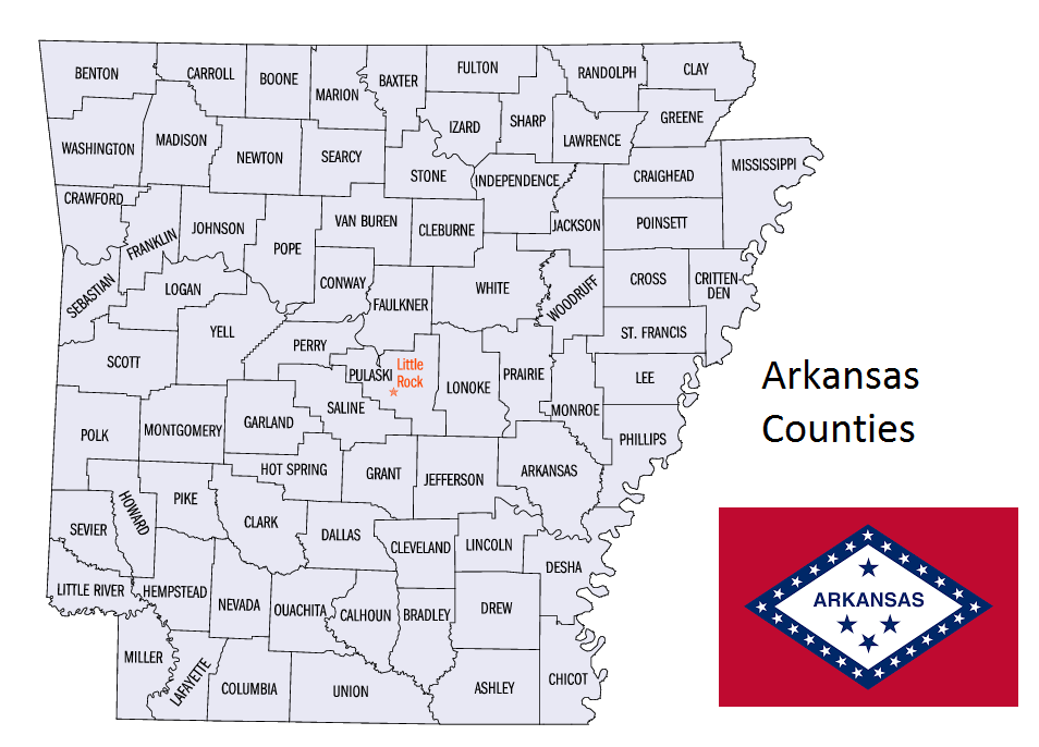
Map of Arkansas Counties