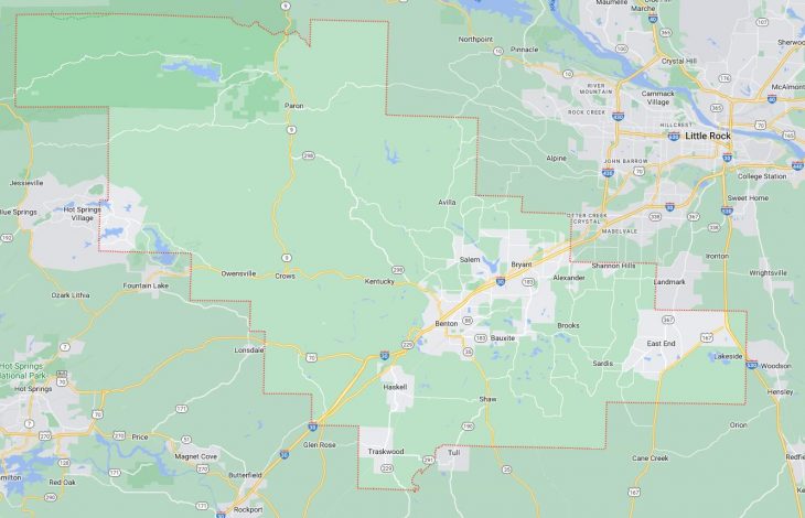
Cities and Towns in Saline County, Arkansas
Founded on November 2, 1835, Saline County is one of 75 counties in the state of Arkansas. Historically, Saline County was formed from Independence and Pulaski. The city of Benton is the county seat. With FIPS code of 125, Saline County has a population of 125,233 and area of 730.46 square miles (1,892 km²).
List of all cities in Saline County, AR alphabetically
City/Town | Postal Code | Area Code |
Alexander, AR | 72002 | 501 |
Bauxite, AR | 72011 | 501 |
Benton, AR | 72015 | 501 |
72018 | 501 | |
72019 | 501 | |
72022 | 501 | |
72158 | 501 | |
Bryant, AR | 72015 | 501 |
72019 | 501 | |
72022 | 501 | |
72089 | 501 | |
East End, AR | 72065 | 501 |
Fenter, AR | 72167 | 501 |
Haskell, AR | 72015 | 501 |
Hensley, AR | 72065 | 501 |
Mabelvale, AR | 72103 | 501 |
Paron, AR | 72122 | 501 |
Royal Oak, AR | 72103 | 501 |
Shannon Hills, AR | 72103 | 501 |
Traskwood, AR | 72167 | 501 |
Tull, AR | 72015 | 501 |
Major Cities and Towns in Saline County, Arkansas
Benton
- Area: 23.4 square miles
- Population: 37,214 (2020 Census)
- ZIP Codes: 72015, 72019, 72158
- Latitude and Longitude: 34.5645° N, 92.5868° W
Location and History
Benton, the county seat of Saline County, is located in central Arkansas, approximately 25 miles southwest of Little Rock. Founded in 1837, Benton was named after Missouri Senator Thomas Hart Benton, who was a strong advocate for westward expansion. The city developed as a center for agriculture and trade, benefiting from its location along the Saline River. During the late 19th and early 20th centuries, Benton became known for its production of bauxite, a mineral essential for aluminum manufacturing, which significantly contributed to its growth. The city played a crucial role during World War II, as bauxite mining in the area helped meet the demand for aluminum. Today, Benton is a thriving suburban community with a diverse economy that includes manufacturing, retail, and services. Its proximity to Little Rock makes it a desirable location for residents seeking a balance between small-town living and access to urban amenities.
Major Schools and Landmarks
Benton is served by the Benton School District, which includes Benton High School, Benton Junior High School, and several elementary schools. The schools are known for their strong academic programs and active participation in sports and extracurricular activities. Major landmarks in Benton include the historic Saline County Courthouse, a beautiful example of Classical Revival architecture, and Tyndall Park, a popular recreational area that features walking trails, playgrounds, and sports fields. The Royal Theatre, a historic venue in downtown Benton, hosts various community events and performances, contributing to the city’s cultural life. Additionally, the nearby Saline River provides opportunities for fishing, kayaking, and other outdoor activities, making Benton a well-rounded community with a rich history and a vibrant present.
Bryant
- Area: 21.1 square miles
- Population: 20,410 (2020 Census)
- ZIP Codes: 72022, 72089
- Latitude and Longitude: 34.6104° N, 92.4918° W
Location and History
Bryant, one of the fastest-growing cities in Arkansas, is located in Saline County, just southwest of Little Rock. Established in the late 19th century as a small farming community, Bryant remained relatively quiet until the latter half of the 20th century when suburban growth from Little Rock began to influence the area. The construction of Interstate 30 in the 1960s significantly improved access to Bryant, spurring residential and commercial development. Over the past few decades, Bryant has transformed into a bustling suburban city, known for its excellent schools, family-friendly atmosphere, and growing economy. The city has attracted numerous businesses, contributing to its status as a desirable place to live and work within the Greater Little Rock area.
Major Schools and Landmarks
Bryant is served by the Bryant School District, which includes Bryant High School, Bryant Middle School, and several elementary schools. The district is renowned for its high academic standards and robust extracurricular programs, particularly in athletics. Major landmarks in Bryant include Bishop Park, a large recreational complex featuring sports fields, a community center, walking trails, and a fishing lake. Another significant site is the Bryant Historical Cemetery, which reflects the town’s early history and the legacy of its founding families. The Alcoa Exchange Shopping Center, a major retail hub, serves as a commercial focal point for residents. With its modern amenities, strong sense of community, and convenient location, Bryant continues to be a thriving and growing part of Saline County.
Haskell
- Area: 5.4 square miles
- Population: 4,076 (2020 Census)
- ZIP Codes: 72015
- Latitude and Longitude: 34.5026° N, 92.6443° W
Location and History
Haskell is a small city located in the western part of Saline County, Arkansas. The town was established in the early 20th century and was named after a local family who played a significant role in its development. Haskell’s history is closely tied to agriculture, with farming and timber being the primary economic activities for much of its early years. The construction of railroads in the area provided a boost to the local economy by improving transportation and trade. Over time, Haskell grew slowly but steadily, maintaining its rural character while gradually expanding its residential and commercial areas. Today, Haskell is a quiet, close-knit community that offers a peaceful environment for its residents, with easy access to the amenities of nearby Benton and Bryant.
Major Schools and Landmarks
Haskell is served by the Harmony Grove School District, which includes Harmony Grove High School and Harmony Grove Middle School. The schools are known for their supportive community atmosphere and active participation in local events. Significant landmarks in Haskell include the Harmony Grove Sports Complex, which provides facilities for various sports and community activities, and the historic Haskell Cemetery, which offers a glimpse into the town’s past. The city is also home to several local parks, such as Haskell Park, which features playgrounds, picnic areas, and walking trails. Haskell’s annual community events, such as the Haskell Harvest Festival, celebrate the town’s agricultural heritage and bring residents together for a day of fun and festivities.
Shannon Hills
- Area: 3.1 square miles
- Population: 3,657 (2020 Census)
- ZIP Codes: 72002
- Latitude and Longitude: 34.6132° N, 92.4018° W
Location and History
Shannon Hills is a small city located in the northeastern part of Saline County, Arkansas. The town was established in the mid-20th century as a suburban community, benefiting from its proximity to Little Rock and the rapid growth of the surrounding area. Originally a rural area, Shannon Hills experienced significant development in the 1970s and 1980s as more families moved out of Little Rock in search of a quieter, suburban lifestyle. The city’s growth has been driven by residential development, with many new neighborhoods and housing projects being built over the years. Today, Shannon Hills is a peaceful, residential community that offers a small-town atmosphere while still being close to the amenities of Little Rock and other nearby cities.
Major Schools and Landmarks
Shannon Hills is part of the Bryant School District, with students attending schools in nearby Bryant. The city itself is primarily residential, with several parks and green spaces that provide recreational opportunities for residents. Key landmarks include the Shannon Hills Community Center, which serves as a gathering place for local events and activities, and the Shannon Hills Park, which features playgrounds, walking trails, and picnic areas. The city’s location near major highways also provides easy access to shopping, dining, and entertainment options in the larger cities of Bryant and Little Rock. Shannon Hills is known for its strong community spirit, with local events and gatherings that foster a sense of connection among residents.
Bauxite
- Area: 2.6 square miles
- Population: 573 (2020 Census)
- ZIP Codes: 72011
- Latitude and Longitude: 34.5554° N, 92.5084° W
Location and History
Bauxite is a small town in Saline County, Arkansas, with a rich history tied to the mining industry. The town was established in the early 20th century and named after the mineral bauxite, which was discovered in abundance in the area. Bauxite became the center of the global aluminum industry during World War II, as the town’s mines provided the essential raw material for aluminum production, which was crucial for the war effort. The town was essentially built by the mining company, with housing, schools, and other amenities provided for the workers and their families. After the war, the demand for bauxite declined, and the town’s population decreased as many of the mines closed. Despite this, Bauxite has retained its identity as a proud, historic community with a deep connection to its industrial past.
Major Schools and Landmarks
Bauxite is part of the Bauxite School District, with Bauxite High School serving as the main educational institution. The school is known for its strong academic and athletic programs. Major landmarks in Bauxite include the Bauxite Historical Association Museum, which preserves the history of the town’s mining industry and its impact on the region. The museum is housed in a former company store and features exhibits on the history of bauxite mining and the town’s role in the aluminum industry. The nearby Bauxite Mines Nature Reserve offers hiking trails and opportunities to explore the area’s natural beauty. Bauxite’s annual Mining Festival celebrates the town’s history with parades, music, and community activities, reflecting the strong sense of pride among its residents.
Alexander
- Area: 2.2 square miles
- Population: 3,385 (2020 Census)
- ZIP Codes: 72002
- Latitude and Longitude: 34.6195° N, 92.4429° W
Location and History
Alexander is a small city located in the northeastern part of Saline County, Arkansas, on the border with Pulaski County. The town was established in the late 19th century and named after an early settler, William Alexander. Alexander’s history is closely tied to the development of the railroad, which played a significant role in the town’s growth by facilitating the transportation of goods and people. Over the years, Alexander has developed as a residential community, benefiting from its proximity to Little Rock and other growing cities in the region. The town has maintained a small-town atmosphere while gradually expanding its residential and commercial areas. Today, Alexander is known for its quiet neighborhoods and convenient location near major highways, making it an attractive place for those who work in nearby urban areas but prefer to live in a more suburban environment.
Major Schools and Landmarks
Alexander is served by the Bryant and Pulaski County Special School Districts, with students attending schools in nearby Bryant or Little Rock. The city itself is largely residential, with a few local parks and green spaces that provide recreational opportunities for residents. Significant landmarks in Alexander include the historic Alexander Cemetery, which dates back to the town’s early days and reflects its rich history. The city’s proximity to larger urban areas allows residents easy access to shopping, dining, and entertainment options, while still enjoying the peace and quiet of suburban life. Alexander’s annual community events, such as the Alexander Summer Festival, bring residents together for celebrations that highlight the town’s strong community spirit and connection to its past.