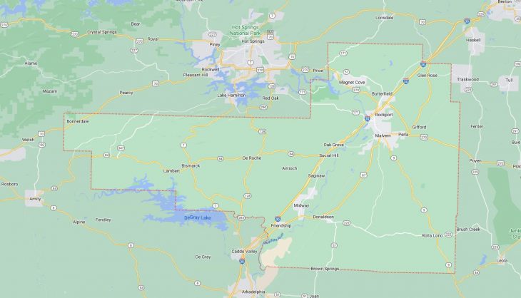
Cities and Towns in Hot Spring County, Arkansas

Founded on November 2, 1829, Hot Spring County is one of 75 counties in the state of Arkansas. Historically, Hot Spring County was formed from Clark County and later from Montgomery County (prior 1880). The city of Malvern is the county seat. With FIPS code of 59, Hot Spring County has a population of 33,148 and area of 622.16 square miles (1,611 km²).

List of all cities in Hot Spring County, AR alphabetically

City/Town Postal Code Area Code
Bismarck, AR 71929 501
Bonnerdale, AR 71933 501
Brown Springs, AR 72104 501
Butterfield, AR 72104 501
Donaldson, AR 71941 501
Durian, AR 72104 501
Friendship, AR 71942 501
Gifford, AR 72104 501
Glen Rose, AR 72104 501
Jones Mill, AR 72105 501
Lambert, AR 71929 501
Magnet Cove, AR 72104 501
Malvern, AR 72104 501
72105 501
Mazarn, AR 71933 501
Perla, AR 72104 501
Rockport, AR 72104 501
Rolla, AR 72104 501
Saginaw, AR 71941 501
Social Hill, AR 72104 501

Major Cities and Towns in Hot Spring County, Arkansas

Malvern

Area, Population, and Coordinates

  • Area: 8.7 square miles
  • Population: 10,931 (as of the last census)
  • ZIP Codes: 72104
  • Latitude and Longitude:
    • Latitude: 34.3620° N
    • Longitude: 92.8124° W

Location and History

Malvern is the county seat and largest city in Hot Spring County, Arkansas. Founded in 1870, the city was named after Malvern Hill in Virginia. Malvern’s establishment was closely tied to the construction of the Cairo & Fulton Railroad, which later became part of the St. Louis, Iron Mountain, and Southern Railway. The city quickly grew as a center for trade and industry, particularly in the brick manufacturing sector, earning it the nickname “The Brick Capital of the World.” The city’s economy has diversified over the years, but its industrial roots remain strong, with manufacturing still playing a significant role. Malvern is also known for its proximity to the Ouachita River, which has contributed to its development as a recreational destination.

Major Schools and Landmarks

Malvern is served by the Malvern School District, which includes Malvern High School, Malvern Middle School, and several elementary schools. The city is also home to the College of the Ouachitas, a two-year community college offering a variety of academic programs. Key landmarks in Malvern include the Hot Spring County Courthouse, a historic building located in the heart of downtown, and the Brickfest, an annual event that celebrates the city’s brick-making heritage with a weekend of festivities. The nearby Ouachita River provides opportunities for fishing, boating, and other outdoor activities, making it a popular destination for residents and visitors alike.

Rockport

Area, Population, and Coordinates

  • Area: 1.7 square miles
  • Population: 755 (as of the last census)
  • ZIP Codes: 72104
  • Latitude and Longitude:
    • Latitude: 34.3765° N
    • Longitude: 92.8113° W

Location and History

Rockport is a small town located just northeast of Malvern in Hot Spring County, Arkansas. The town was founded in the early 19th century and is one of the oldest settlements in the county. Rockport’s history is closely tied to the Ouachita River, which served as a vital transportation route for early settlers and played a significant role in the town’s development. The town’s name is derived from the rocky shoals found along the river. Over the years, Rockport has remained a small, close-knit community with a rich history. The town’s economy has traditionally been based on agriculture, though it has also benefited from its proximity to Malvern.

Major Schools and Landmarks

Rockport is part of the Malvern School District, with students attending schools in nearby Malvern. The town is home to several historic landmarks, including the Rockport Methodist Church, which dates back to the 1800s and is one of the oldest churches in the county. The Ouachita River continues to be a central feature of the town, offering opportunities for fishing, boating, and other outdoor activities. The town’s annual events, such as the Rockport Day, bring the community together to celebrate their shared heritage and foster a strong sense of local pride. Rockport’s historical significance and natural beauty make it a unique and charming place to live.

Donaldson

Area, Population, and Coordinates

  • Area: 0.9 square miles
  • Population: 301 (as of the last census)
  • ZIP Codes: 71941
  • Latitude and Longitude:
    • Latitude: 34.2376° N
    • Longitude: 92.9235° W

Location and History

Donaldson is a small town located in the southern part of Hot Spring County, Arkansas. The town was established in the late 19th century and developed as a rural farming community. Donaldson’s economy has historically been based on agriculture, with cotton and livestock being the primary economic activities. The town’s location along the railroad contributed to its growth, making it a small but important part of the region’s agricultural network. Despite its small size, Donaldson has a rich history and a strong sense of community, with residents taking pride in their town’s heritage.

Major Schools and Landmarks

Donaldson is served by the Ouachita School District, which includes Ouachita High School and Ouachita Elementary School. The town is home to several local landmarks, including the historic Donaldson Depot, which served as a key transportation hub during the height of the town’s agricultural era. The surrounding farmland and nearby Ouachita National Forest offer opportunities for hunting, fishing, and other outdoor activities, reflecting Donaldson’s connection to the natural environment. The town’s annual events, such as the Donaldson Community Picnic, bring residents together to celebrate their shared heritage and foster a strong sense of community spirit.

Perla

Area, Population, and Coordinates

  • Area: 0.4 square miles
  • Population: 241 (as of the last census)
  • ZIP Codes: 72104
  • Latitude and Longitude:
    • Latitude: 34.3659° N
    • Longitude: 92.7696° W

Location and History

Perla is a small town located just west of Malvern in Hot Spring County, Arkansas. The town was established in the early 20th century and developed primarily as a residential community for workers in the nearby brick and timber industries. Perla’s economy has traditionally been based on manufacturing, with the town benefiting from its proximity to Malvern’s industrial base. Despite its small size, Perla has maintained a close-knit community atmosphere, with a focus on providing a peaceful, rural lifestyle for its residents.

Major Schools and Landmarks

Perla is part of the Malvern School District, with students attending schools in nearby Malvern. The town is home to several local landmarks, including the Perla Baptist Church, which has been a central gathering place for the community for many years. The nearby Ouachita River and surrounding natural areas offer opportunities for outdoor activities, such as fishing, boating, and hiking. Perla’s annual events, such as the Perla Day Festival, bring residents together to celebrate their shared heritage and foster a strong sense of community pride. The town’s small size and rural setting make it an ideal place for those seeking a quiet, country lifestyle.

Map of Cities in Hot Spring County, AR

Map of Cities in Hot Spring County, AR