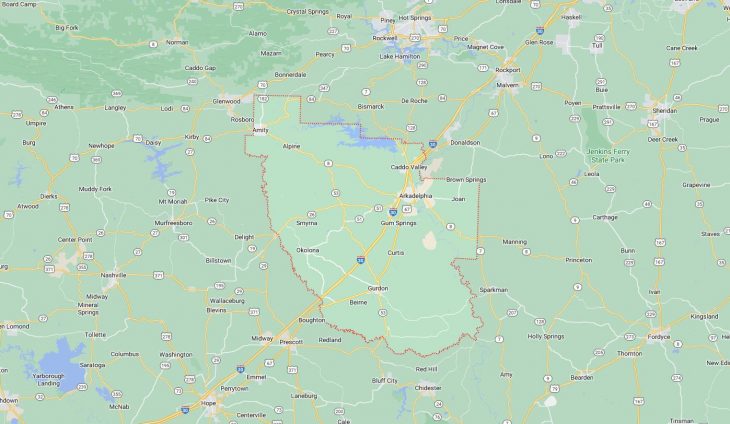
Cities and Towns in Clark County, Arkansas

Founded on December 15, 1818, Clark County is one of 75 counties in the state of Arkansas. Historically, Clark County was formed from Arkansas (1818). The city of Arkadelphia is the county seat. With FIPS code of 19, Clark County has a population of 21,321 and area of 882.60 square miles (2,286 km²).

List of all cities in Clark County, AR alphabetically

City/Town Postal Code Area Code
Alpine, AR 71920 870
71921 870
Amity, AR 71920 870
71921 870
Arkadelphia, AR 71923 870
71998 870
71999 870
Beirne, AR 71721 870
Caddo Valley, AR 71923 870
Caney Valley, AR 71921 870
Curtis, AR 71728 870
Dalark, AR 71923 870
Degray, AR 71923 870
Elm, AR 71921 870
Fendley, AR 71921 870
Griffithtown, AR 71923 870
Gum Springs, AR 71923 870
Gurdon, AR 71743 870
Hearn, AR 71923 870
Henderson State University, AR 71999 870
Hollywood, AR 71923 870
Joan, AR 71923 870
Okolona, AR 71962 870
Ouachita Baptist University, AR 71998 870
Point Cedar, AR 71921 870
Richwood, AR 71923 870
Rosboro, AR 71921 870
West Gum Springs, AR 71923 870
Whelen Springs, AR 71772 870
Witherspoon, AR 71923 870

Major Cities and Towns in Clark County, Arkansas

Arkadelphia

Area, Population, and Coordinates

  • Area: 7.3 square miles
  • Population: 10,380 (as of the last census)
  • ZIP Codes: 71923, 71998, 71999
  • Latitude and Longitude:
    • Latitude: 34.1204° N
    • Longitude: 93.0538° W

Location and History

Arkadelphia is the county seat and largest city in Clark County, Arkansas, located along the Ouachita River in the southwestern part of the state. The city was founded in 1809 and is one of the oldest settlements in the region. Originally known as Blakelytown, it was renamed Arkadelphia in 1839, combining “Arkansas” and “Philadelphia” to reflect the area’s growth and prosperity. The city’s economy was historically based on timber, cotton, and other agricultural products, but it has since diversified to include education, manufacturing, and healthcare. Arkadelphia is home to two universities, Henderson State University and Ouachita Baptist University, making education a significant part of the city’s identity.

Major Schools and Landmarks

Arkadelphia is served by the Arkadelphia School District, which includes Arkadelphia High School, Goza Middle School, and several elementary schools. The city is home to several significant landmarks, including the historic Clark County Courthouse and the Iron Mountain Depot, which reflects the city’s past as a key railroad hub. The Ouachita Baptist University and Henderson State University campuses add to the cultural and intellectual life of the city, hosting numerous events, lectures, and performances. The DeSoto Bluff Trail offers scenic views of the Ouachita River and the surrounding landscape, making it a popular destination for residents and visitors alike. The annual Arkadelphia Festival of the Arts and the Battle of the Ravine, a historic college football rivalry, are key events that showcase the city’s rich history and vibrant community spirit.

Gurdon

Area, Population, and Coordinates

  • Area: 2.9 square miles
  • Population: 2,059 (as of the last census)
  • ZIP Codes: 71743
  • Latitude and Longitude:
    • Latitude: 33.9173° N
    • Longitude: 93.1530° W

Location and History

Gurdon is a small town located in the southern part of Clark County, Arkansas. The town was established in the late 19th century as a result of the expansion of the railroad and the timber industry. Gurdon quickly grew as a hub for the lumber business, with several sawmills and related industries providing employment for many residents. The town was named after Henry Gurdon Marquand, a financier and philanthropist who was instrumental in the development of the railroad in the area. Today, Gurdon retains its small-town charm, with a strong connection to its history and the surrounding forests that have long been a part of its identity.

Major Schools and Landmarks

Gurdon is served by the Gurdon School District, which includes Gurdon High School, Cabe Middle School, and Gurdon Primary School. The town is home to several local landmarks, including the Gurdon Light, a mysterious light phenomenon that has been the subject of local folklore for decades. The Gurdon City Park offers recreational facilities for the community, including a playground, picnic areas, and sports fields. The nearby Ouachita National Forest provides opportunities for hiking, camping, and wildlife viewing, making it a popular destination for outdoor enthusiasts. Gurdon’s annual Forest Festival celebrates the town’s heritage with a parade, live music, and other family-friendly activities, highlighting the community’s pride in its history and traditions.

Amity

Area, Population, and Coordinates

  • Area: 1.1 square miles
  • Population: 723 (as of the last census)
  • ZIP Codes: 71921
  • Latitude and Longitude:
    • Latitude: 34.2683° N
    • Longitude: 93.4655° W

Location and History

Amity is a small town located in the western part of Clark County, Arkansas. The town was founded in the mid-19th century and developed as a farming and timber community. Amity’s location near the Ouachita Mountains provided access to abundant natural resources, particularly timber, which became a key part of the town’s economy. The town’s name, which means “friendship,” reflects the close-knit community that has characterized Amity since its early days. Despite its small size, Amity has maintained its rural charm and continues to be a place where residents value tradition and community.

Major Schools and Landmarks

Amity is served by the Centerpoint School District, which includes Centerpoint High School, Centerpoint Middle School, and Amity Elementary School. The town’s most notable landmark is the Amity Trade Days grounds, which hosts a large monthly market that attracts vendors and visitors from across the region. The nearby Lake DeGray offers opportunities for fishing, boating, and camping, making it a popular destination for residents and visitors alike. The town’s annual events, such as the Amity Christmas Parade and the Fourth of July celebration, bring the community together to celebrate its heritage and foster a strong sense of community spirit.

Caddo Valley

Area, Population, and Coordinates

  • Area: 3.3 square miles
  • Population: 635 (as of the last census)
  • ZIP Codes: 71923
  • Latitude and Longitude:
    • Latitude: 34.1801° N
    • Longitude: 93.0710° W

Location and History

Caddo Valley is a small town located in the northeastern part of Clark County, Arkansas, near the confluence of the Caddo and Ouachita rivers. The town was established in the mid-20th century as a result of the construction of DeGray Dam, which created DeGray Lake. Caddo Valley quickly developed as a tourist destination, with the lake and surrounding natural beauty attracting visitors for fishing, boating, and other outdoor activities. The town’s economy is largely based on tourism, with several hotels, restaurants, and recreational facilities serving visitors to the area. Caddo Valley’s location near major highways has also made it a convenient stop for travelers passing through the region.

Major Schools and Landmarks

Caddo Valley is part of the Arkadelphia School District, with students attending schools in nearby Arkadelphia. The town’s most significant landmark is DeGray Lake Resort State Park, which offers a range of outdoor activities, including golf, hiking, and water sports. The park’s lodge and marina are popular destinations for both locals and tourists, providing access to the lake’s many recreational opportunities. The nearby DeGray Dam and Lake are engineering marvels that play a key role in flood control and hydroelectric power generation in the region. Caddo Valley’s annual community events, such as the Caddo Valley BBQ Festival, celebrate the town’s connection to the outdoors and its role as a gateway to the natural beauty of the region.

Map of Cities in Clark County, AR

Map of Cities in Clark County, AR