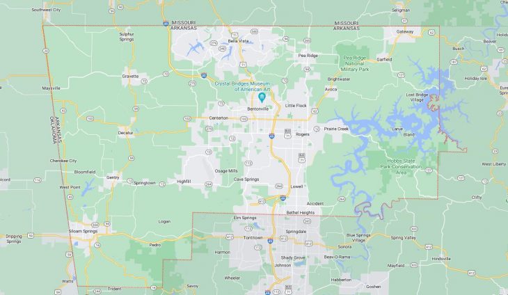
Cities and Towns in Benton County, Arkansas

Founded on September 30, 1836, Benton County is one of 75 counties in the state of Arkansas. Historically, Benton County was formed from Washington County. The city of Bentonville is the county seat. With FIPS code of 7, Benton County has a population of 293,692 and area of 884.86 square miles (2,292 km²).

List of all cities in Benton County, AR alphabetically

City/Town Postal Code Area Code
Avoca, AR 72711 479
Bella Vista, AR 72714 479
72715 479
Bentonville, AR 72712 479
72716 479
Cave Springs, AR 72718 479
Centerton, AR 72719 479
Decatur, AR 72722 479
Garfield, AR 72732 479
Gateway, AR 72733 479
Gentry, AR 72734 479
Gravette, AR 72736 479
Hiwasse, AR 72739 479
Lowell, AR 72745 479
Maysville, AR 72747 479
Pea Ridge, AR 72751 479
Rogers, AR 72756 479
72757 479
72758 479
Siloam Springs, AR 72761 479
Springtown, AR 72734 479
Sulphur Springs, AR 72768 479
The Highlands, AR 72715 479
Wal-Mart Inc, AR 72716 479

Major Cities and Towns in Benton County, Arkansas

Bentonville

Area, Population, and Coordinates

  • Area: 31.5 square miles
  • Population: 54,164 (as of the last census)
  • ZIP Codes: 72712, 72716
  • Latitude and Longitude:
    • Latitude: 36.3729° N
    • Longitude: 94.2088° W

Location and History

Bentonville, the county seat of Benton County, is one of the fastest-growing cities in Arkansas, located in the northwestern part of the state. The city was founded in 1837 and named after Senator Thomas Hart Benton of Missouri, a prominent advocate of westward expansion. Originally, Bentonville served as a trading post for local agriculture, particularly apples. However, the city’s most significant transformation occurred in the 20th century when it became the headquarters of Walmart, the world’s largest retailer, founded by Sam Walton in 1962. This development has dramatically shaped Bentonville’s economy, culture, and growth, turning it into a bustling hub of business and innovation while retaining its small-town charm.

Major Schools and Landmarks

Bentonville is served by the Bentonville School District, which includes Bentonville High School, Bentonville West High School, and several elementary and middle schools. The city is home to several significant landmarks, including the Walmart Museum, which chronicles the history of Walmart and its impact on Bentonville. Crystal Bridges Museum of American Art, founded by Alice Walton, is another major landmark, featuring an extensive collection of American art and hosting numerous cultural events. The Bentonville Square, the historic heart of the city, is a popular gathering spot with shops, restaurants, and the annual Bentonville Film Festival. The nearby Slaughter Pen Mountain Bike Park offers extensive trails for outdoor enthusiasts, further enhancing Bentonville’s appeal as a destination for both culture and recreation.

Rogers

Area, Population, and Coordinates

  • Area: 37.6 square miles
  • Population: 68,669 (as of the last census)
  • ZIP Codes: 72756, 72757, 72758
  • Latitude and Longitude:
    • Latitude: 36.3320° N
    • Longitude: 94.1185° W

Location and History

Rogers is a thriving city in Benton County, located in the northwestern corner of Arkansas. The city was established in 1881 as a stop on the St. Louis–San Francisco Railway, named after Captain Charles Warrington Rogers, a railroad executive. Rogers quickly developed as a commercial center, benefiting from its strategic location along the railroad. The city’s economy historically revolved around agriculture, particularly poultry and dairy farming, but has diversified significantly in recent decades. Rogers has grown into a major retail and business hub, with a vibrant downtown area that blends historic charm with modern amenities. The city’s growth has been fueled in part by its proximity to the headquarters of Walmart, located in neighboring Bentonville.

Major Schools and Landmarks

Rogers is served by the Rogers School District, which includes Rogers High School, Heritage High School, and several elementary and middle schools. The city is home to several key landmarks, including the Daisy Airgun Museum, which showcases the history of the Daisy BB gun, and the Rogers Historical Museum, offering insights into the city’s past. Lake Atalanta, located just east of downtown Rogers, is a popular spot for outdoor activities, including fishing, hiking, and picnicking. The Pinnacle Hills Promenade, a large shopping center, serves as a major retail destination for the region. Additionally, the annual Frisco Festival celebrates Rogers’ railroad heritage with live music, food, and family-friendly activities, drawing visitors from across the area.

Bella Vista

Area, Population, and Coordinates

  • Area: 45.3 square miles
  • Population: 28,092 (as of the last census)
  • ZIP Codes: 72714, 72715
  • Latitude and Longitude:
    • Latitude: 36.4806° N
    • Longitude: 94.2714° W

Location and History

Bella Vista is a picturesque city located in the northern part of Benton County, Arkansas, near the Missouri border. The city was originally established in 1965 as a retirement community by John Cooper Sr., the founder of Cooper Communities, Inc. Over time, Bella Vista evolved from a retirement village into a full-fledged city, attracting residents of all ages. The city’s scenic beauty, with its rolling hills, lakes, and forests, has made it a popular destination for those seeking a tranquil lifestyle. Bella Vista was officially incorporated as a city in 2007, and since then, it has experienced significant growth, becoming a vibrant community with a focus on outdoor recreation and community living.

Major Schools and Landmarks

Bella Vista is part of the Bentonville School District, with students attending schools in nearby Bentonville, including Bentonville High School and several elementary and middle schools. The city is known for its extensive amenities, including seven lakes, multiple golf courses, and over 100 miles of nature trails, making it a haven for outdoor enthusiasts. The Bella Vista Country Club and the Metfield Clubhouse are popular spots for golf, tennis, and social activities. The city’s trail system, including the Back 40 Trails, offers opportunities for hiking, mountain biking, and exploring the natural beauty of the Ozarks. The Mildred B. Cooper Memorial Chapel, designed by renowned architect E. Fay Jones, is a significant landmark, celebrated for its stunning architecture and serene woodland setting.

Siloam Springs

Area, Population, and Coordinates

  • Area: 11.0 square miles
  • Population: 17,287 (as of the last census)
  • ZIP Codes: 72761
  • Latitude and Longitude:
    • Latitude: 36.1884° N
    • Longitude: 94.5405° W

Location and History

Siloam Springs is a charming city located in the southwestern part of Benton County, Arkansas, near the Oklahoma border. The city was founded in 1882 and named after the nearby natural springs, which were believed to have healing properties. Siloam Springs quickly developed as a health resort, attracting visitors seeking the therapeutic benefits of its waters. The city’s location along Sager Creek and its picturesque downtown, with well-preserved historic buildings, add to its appeal. Over time, Siloam Springs has evolved into a center for education and culture, home to John Brown University, a private Christian university that plays a significant role in the community.

Major Schools and Landmarks

Siloam Springs is served by the Siloam Springs School District, which includes Siloam Springs High School, Siloam Springs Middle School, and several elementary schools. The city’s most notable landmark is John Brown University, known for its beautiful campus and strong academic programs. The downtown area is another key attraction, with historic buildings, shops, and restaurants that reflect the city’s rich heritage. The Sager Creek Arts Center hosts a variety of cultural events, including art exhibits, theater performances, and concerts. The nearby Ozark National Forest and Natural Falls State Park in Oklahoma offer additional opportunities for outdoor activities, making Siloam Springs a great place for nature lovers and adventurers.

Map of Cities in Benton County, AR

Map of Cities in Benton County, AR