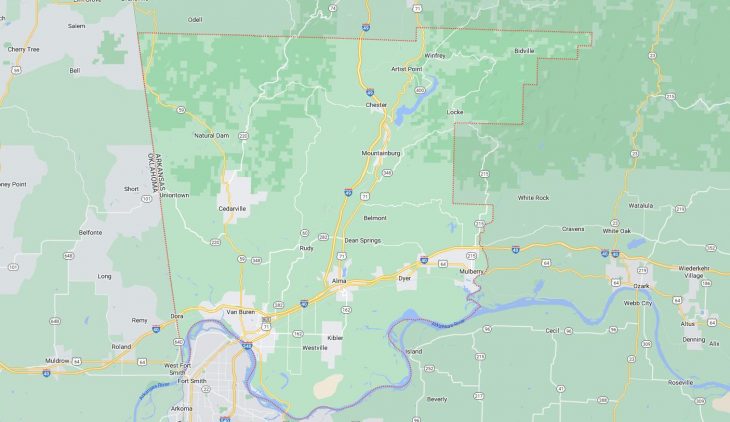
Cities and Towns in Crawford County, Arkansas
Founded on October 18, 1820, Crawford County is one of 75 counties in the state of Arkansas. Historically, Crawford County was formed from Pulaski County. The city of Van Buren is the county seat. With FIPS code of 33, Crawford County has a population of 60,378 and area of 604.20 square miles (1,565 km²).
List of all cities in Crawford County, AR alphabetically
City/Town | Postal Code | Area Code |
Alma, AR | 72921 | 479 |
Cedarville, AR | 72932 | 479 |
Chester, AR | 72934 | 479 |
Dyer, AR | 72935 | 479 |
Mountainburg, AR | 72946 | 479 |
Mulberry, AR | 72947 | 479 |
Natural Dam, AR | 72948 | 479 |
Rudy, AR | 72952 | 479 |
Uniontown, AR | 72955 | 479 |
Van Buren, AR | 72956 | 479 |
72957 | 479 |
Major Cities and Towns in Crawford County, Arkansas
Van Buren
Area, Population, and Coordinates
- Area: 16.5 square miles
- Population: 23,218 (as of the last census)
- ZIP Codes: 72956, 72957
- Latitude and Longitude:
- Latitude: 35.4362° N
- Longitude: 94.3488° W
Location and History
Van Buren is the county seat and largest city in Crawford County, Arkansas, located along the Arkansas River in the northwestern part of the state. The city was founded in 1831 and named after Martin Van Buren, who was Vice President of the United States at the time. Van Buren grew rapidly due to its strategic location on the river, making it an important port and trade center in the region. The arrival of the railroad in the late 19th century further cemented Van Buren’s status as a transportation hub, contributing to its economic growth and development. Today, Van Buren retains its historical charm with a well-preserved downtown area and a thriving community that blends the past with modern amenities.
Major Schools and Landmarks
Van Buren is served by the Van Buren School District, which includes Van Buren High School, Northridge Middle School, and several elementary schools. The city is home to several significant landmarks, including the Van Buren Historic District, which features a collection of 19th-century buildings that reflect the city’s rich history. The Old Frisco Depot, now a museum, offers insights into the city’s railroad heritage. The nearby Lee Creek Park and the Arkansas River provide opportunities for outdoor recreation, including hiking, fishing, and boating. Van Buren’s annual Old Timers Day Steampunk Festival celebrates the city’s history with a blend of old-time traditions and modern-day fun, drawing visitors from across the region.
Alma
Area, Population, and Coordinates
- Area: 5.9 square miles
- Population: 5,734 (as of the last census)
- ZIP Codes: 72921
- Latitude and Longitude:
- Latitude: 35.4881° N
- Longitude: 94.2219° W
Location and History
Alma is a small city located in the southeastern part of Crawford County, Arkansas, known as the “Spinach Capital of the World” due to its significant spinach production. The town was established in the late 19th century and grew as an agricultural center, with farming, particularly spinach and other leafy greens, being the mainstay of its economy. Alma’s location along Interstate 40 has made it a convenient stop for travelers and a gateway to the Ozark Mountains. The town has maintained its agricultural heritage while also developing into a modern community with a focus on family-friendly living and outdoor recreation.
Major Schools and Landmarks
Alma is served by the Alma School District, which includes Alma High School, Alma Middle School, and Alma Primary School. The city is home to several key landmarks, including the Alma Performing Arts Center, which hosts a variety of cultural events, and the Alma Aquatic Park, a popular destination for families during the summer months. The annual Spinach Festival celebrates Alma’s agricultural heritage, featuring a variety of spinach-themed activities, food, and entertainment. The nearby Ozark National Forest offers opportunities for hiking, camping, and exploring the natural beauty of the region, making Alma an ideal location for outdoor enthusiasts.
Mulberry
Area, Population, and Coordinates
- Area: 7.7 square miles
- Population: 1,655 (as of the last census)
- ZIP Codes: 72947
- Latitude and Longitude:
- Latitude: 35.5040° N
- Longitude: 94.0593° W
Location and History
Mulberry is a small town located in the northeastern part of Crawford County, Arkansas, along the banks of the Mulberry River. The town was established in the mid-19th century and named after the Mulberry River, which flows through the area. Mulberry developed as a farming and timber community, with agriculture and logging being the primary economic activities. The town’s location near the river made it an important site for transportation and trade in the early days of its development. Today, Mulberry remains a quiet, rural community with a strong connection to its natural surroundings.
Major Schools and Landmarks
Mulberry is part of the Mulberry/Pleasant View Bi-County School District, with students attending Mulberry High School and Mulberry Middle School. The town is home to several local landmarks, including the Mulberry River, which offers opportunities for fishing, canoeing, and other outdoor activities. The nearby Ozark National Forest provides additional opportunities for hiking, camping, and exploring the natural beauty of the region. Mulberry’s annual events, such as the Mulberry River Festival, celebrate the town’s heritage and foster a strong sense of community spirit. The town’s small size and rural setting make it an ideal place for those seeking a peaceful, country lifestyle.
Mountainburg
Area, Population, and Coordinates
- Area: 3.1 square miles
- Population: 631 (as of the last census)
- ZIP Codes: 72946
- Latitude and Longitude:
- Latitude: 35.6365° N
- Longitude: 94.1674° W
Location and History
Mountainburg is a small town located in the northern part of Crawford County, Arkansas, nestled in the foothills of the Ozark Mountains. The town was established in the late 19th century and developed as a stop along the Frisco Railway. Mountainburg’s location near the Boston Mountains made it a popular destination for travelers and tourists seeking to explore the natural beauty of the area. The town’s economy has traditionally been based on agriculture and tourism, with the surrounding mountains and forests playing a central role in its development.
Major Schools and Landmarks
Mountainburg is served by the Mountainburg School District, which includes Mountainburg High School, Mountainburg Middle School, and Mountainburg Elementary School. The town is home to several notable landmarks, including the Mountainburg Dragon Statues, which have become a local symbol and popular photo spot. The nearby Lake Fort Smith State Park offers opportunities for camping, fishing, and hiking, making it a popular destination for outdoor enthusiasts. Mountainburg’s annual events, such as the Mountainburg Fall Festival, bring residents together to celebrate their community and enjoy the natural beauty of the Ozarks.