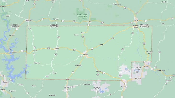
Cities and Towns in Fulton County, Arkansas

Founded on December 21, 1842, Fulton County is one of 75 counties in the state of Arkansas. Historically, Fulton County was formed from Izard County and then later from Lawrence County (prior 1850). The city of Salem is the county seat. With FIPS code of 49, Fulton County has a population of 12,145 and area of 620.32 square miles (1,607 km²).

List of all cities in Fulton County, AR alphabetically

City/Town Postal Code Area Code
Bexar, AR 72515 870
Camp, AR 72520 870
Elizabeth, AR 72531 870
Gepp, AR 72538 870
Glencoe, AR 72539 870
Mammoth Springs, AR 72554 870
Moko, AR 72576 870
Salem, AR 72576 870
Sturkie, AR 72578 870
Viola, AR 72583 870

Major Cities and Towns in Fulton County, Arkansas

Salem

Area, Population, and Coordinates

  • Area: 4.2 square miles
  • Population: 1,635 (as of the last census)
  • ZIP Codes: 72576
  • Latitude and Longitude:
    • Latitude: 36.3709° N
    • Longitude: 91.8235° W

Location and History

Salem is the county seat of Fulton County, Arkansas, located in the north-central part of the state. The city was established in 1844 and has served as the administrative center of the county since its founding. Salem developed as an agricultural community, with farming and livestock being the primary economic activities. The town’s location in the Ozark Mountains provided it with a scenic backdrop and contributed to its development as a small but thriving community. Over the years, Salem has retained its rural charm and close-knit community atmosphere, while also serving as a hub for the surrounding rural areas.

Major Schools and Landmarks

Salem is served by the Salem School District, which includes Salem High School, Salem Junior High, and Salem Elementary School. The town is home to several local landmarks, including the historic Fulton County Courthouse, which has been a central part of the community since the late 19th century. The nearby South Fork River offers opportunities for fishing, boating, and other outdoor activities, making it a popular destination for residents and visitors alike. Salem’s annual events, such as the Fulton County Fair and the Old Soldiers Reunion, bring the community together to celebrate its heritage and foster a strong sense of local pride.

Mammoth Spring

Area, Population, and Coordinates

  • Area: 1.2 square miles
  • Population: 977 (as of the last census)
  • ZIP Codes: 72554
  • Latitude and Longitude:
    • Latitude: 36.4956° N
    • Longitude: 91.5415° W

Location and History

Mammoth Spring is a small town located in the northern part of Fulton County, Arkansas, near the Missouri state line. The town is named after Mammoth Spring, one of the largest natural springs in the United States, which has been a key feature of the area for centuries. The spring has a daily flow of approximately 9 million gallons of water and forms the headwaters of the Spring River, which has been an important waterway for transportation and trade. Mammoth Spring developed as a resort town in the late 19th and early 20th centuries, attracting visitors with its natural beauty and healthful waters. The town’s economy has traditionally been based on tourism, agriculture, and small-scale manufacturing.

Major Schools and Landmarks

Mammoth Spring is served by the Mammoth Spring School District, which includes Mammoth Spring High School and Mammoth Spring Elementary School. The town is home to several significant landmarks, including the Mammoth Spring State Park, which features the spring itself, a historic railroad depot, and a dam that was used for hydroelectric power. The park offers opportunities for fishing, picnicking, and exploring the area’s natural and historical attractions. Mammoth Spring’s annual events, such as the Watermelon Festival, celebrate the town’s unique natural resources and draw visitors from across the region to enjoy food, music, and community activities.

Cherokee Village

Area, Population, and Coordinates

  • Area: 20.8 square miles (extends into Sharp County)
  • Population: 4,671 (as of the last census)
  • ZIP Codes: 72529
  • Latitude and Longitude:
    • Latitude: 36.2928° N
    • Longitude: 91.5257° W

Location and History

Cherokee Village is a planned community located in the eastern part of Fulton County, Arkansas, extending into Sharp County. The community was established in 1954 by developer John A. Cooper as one of the first planned retirement communities in the United States. Cherokee Village was designed to offer a relaxed, resort-like lifestyle with amenities such as golf courses, lakes, and recreational facilities. The community has grown steadily over the years, attracting retirees and families alike who are drawn to its peaceful environment and affordable living. Today, Cherokee Village is known for its scenic beauty, with the Ozark Mountains providing a picturesque backdrop to its lakes, forests, and rolling hills.

Major Schools and Landmarks

Cherokee Village is served by the Highland School District, which includes Highland High School, Highland Middle School, and Cherokee Elementary School. The community is home to several local landmarks, including two 18-hole golf courses, seven lakes, and multiple parks that offer opportunities for boating, fishing, swimming, and hiking. The Cherokee Village Town Center is a focal point for community activities, with shops, restaurants, and event spaces. Cherokee Village’s annual events, such as the Spring Fest and Fall Fest, bring residents together to celebrate the community’s unique lifestyle and foster a strong sense of belonging.

Horseshoe Bend

Area, Population, and Coordinates

  • Area: 14.6 square miles (extends into Izard County)
  • Population: 2,184 (as of the last census)
  • ZIP Codes: 72512
  • Latitude and Longitude:
    • Latitude: 36.2272° N
    • Longitude: 91.7503° W

Location and History

Horseshoe Bend is a small town located in the southwestern part of Fulton County, Arkansas, extending into Izard County. The town was established in the 1960s as a planned retirement community, similar to Cherokee Village. Horseshoe Bend was designed to offer a quiet, resort-like atmosphere with amenities such as golf courses, lakes, and recreational facilities. The town’s name comes from the horseshoe-shaped bend in the Strawberry River, which runs through the area. Horseshoe Bend has attracted retirees and seasonal residents from across the country, drawn by its peaceful environment, scenic beauty, and recreational opportunities.

Major Schools and Landmarks

Horseshoe Bend is part of the Highland School District, with students attending schools in nearby Cherokee Village. The town is home to several local landmarks, including Crown Lake, a 640-acre lake that offers opportunities for boating, fishing, and swimming. The town also features two golf courses, the 18-hole Turkey Mountain Golf Course and the 9-hole Cedar Glade Golf Course, which are popular with residents and visitors alike. Horseshoe Bend’s annual Dogwood Days Festival celebrates the town’s community spirit with a parade, arts and crafts vendors, and various family-friendly activities. The town’s combination of natural beauty and modern amenities makes it an attractive place to live for retirees and those seeking a peaceful, rural lifestyle.

Map of Cities in Fulton County, AR

Map of Cities in Fulton County, AR