Cities and Towns in White County, Arkansas

Founded on October 23, 1835, White County is one of 75 counties in the state of Arkansas. Historically, White County was formed from Independence, Jackson and Pulaski counties. The city of Searcy is the county seat. With FIPS code of 145, White County has a population of 77,207 and area of 1,042.36 square miles (2,700 km²).

List of all cities in White County, AR alphabetically

City/Town Postal Code Area Code
Bald Knob, AR 72010 501
Beebe, AR 72012 501
Bradford, AR 72020 501
Davenport, AR 72121 501
Dewey, AR 72121 501
El Paso, AR 72045 501
Garner, AR 72052 501
Georgetown, AR 72143 501
Gravel Hill, AR 72136 501
Griffithville, AR 72060 501
Hickory Flat, AR 72121 501
Higginson, AR 72068 501
Higgson, AR 72068 501
Judsonia, AR 72081 501
Kenseh, AR 72082 501
72082 501
Kensett, AR 72082 501
Letona, AR 72085 501
Little Red, AR 72121 501
Mc Rae, AR 72102 501
McJester, AR 72121 501
McRae, AR 72102 501
Pangburn, AR 72121 501
Providence, AR 72081 501
Romance, AR 72136 501
Rose Bud, AR 72137 501
Russell, AR 72139 501
Searcy, AR 72143 501
72145 501
72149 501
Sidon, AR 72137 501
Steprock, AR 72081 501
West Point, AR 72178 501

Major Cities and Towns in White County, Arkansas

Searcy

  • Area: 24.2 square miles
  • Population: 24,389 (as of the 2020 Census)
  • Zip Codes: 72143, 72145
  • Latitude and Longitude: 35.2332° N, 91.7334° W

Location and History

Searcy, the county seat of White County, is located in the central part of the state, approximately 50 miles northeast of Little Rock. Founded in 1835, Searcy was named after the Searcy family who were early settlers in the area. The town’s development was influenced by its location along the early transportation routes and its role as a commercial hub in the region. Searcy’s historical growth was further propelled by its designation as the county seat and its strategic position along major rail lines in the late 19th and early 20th centuries. The town has evolved from its agricultural beginnings to become a vibrant city with a diverse economy and a strong community focus.

Major Schools and Landmarks

Searcy is served by the Searcy School District, which includes Searcy High School, Searcy Middle School, and several elementary schools. Major landmarks in Searcy include the White County Courthouse, a historic building central to the town’s administrative functions, and Harding University, a private Christian university known for its academic programs and community engagement. The town also boasts the historic downtown area, which features well-preserved architecture and local shops, reflecting Searcy’s historical and cultural heritage.

Bald Knob

  • Area: 2.6 square miles
  • Population: 2,772 (as of the 2020 Census)
  • Zip Codes: 72010
  • Latitude and Longitude: 35.4016° N, 91.5816° W

Location and History

Bald Knob is located in the northern part of White County, approximately 40 miles northeast of Searcy. Established in the late 19th century, Bald Knob developed as a small agricultural community with a focus on cotton and other crops. The town’s name is derived from the distinctive hill in the area, which was used as a landmark. Bald Knob’s historical significance is tied to its role as a center for local farming and trade, with growth driven by its agricultural base and its position on regional transportation routes.

Major Schools and Landmarks

Bald Knob is served by the Bald Knob School District, which includes Bald Knob High School and Bald Knob Middle School. Key landmarks in the town include the Bald Knob Community Center, which hosts various local events, and the Bald Knob Historical Society Museum, which preserves and displays the town’s history. The town’s location and community facilities reflect its agricultural roots and the local culture of White County.

Judsonia

  • Area: 1.8 square miles
  • Population: 930 (as of the 2020 Census)
  • Zip Codes: 72081
  • Latitude and Longitude: 35.3004° N, 91.6660° W

Location and History

Judsonia is situated in the southeastern part of White County. Founded in 1881, Judsonia’s early growth was driven by its location along the railroad, which facilitated its development as a small agricultural and commercial center. The town was named after a local family and has since grown while maintaining its historical character. Judsonia’s development has been influenced by its agricultural base, including cotton farming, and its role as a local trading post in the region.

Major Schools and Landmarks

Judsonia is served by the Judsonia School District, which includes Judsonia High School and Judsonia Middle School. Notable landmarks in Judsonia include the historic Judsonia Depot, reflecting the town’s transportation history, and the local community center, which hosts events and gatherings. The town’s historical sites and community-focused institutions highlight its role in the region’s agricultural and commercial development.

Kensett

  • Area: 2.7 square miles
  • Population: 1,681 (as of the 2020 Census)
  • Zip Codes: 72082
  • Latitude and Longitude: 35.2866° N, 91.6220° W

Location and History

Kensett is located in the western part of White County, approximately 20 miles west of Searcy. Founded in 1883, Kensett grew as a result of its strategic location along the railroad, which facilitated its development as a local trade and agricultural center. The town’s history reflects its role in the cotton economy and its growth as a key community in the county. Kensett’s historical development has been closely tied to its transportation links and agricultural base.

Major Schools and Landmarks

Kensett is served by the Kensett School District, which includes Kensett High School and Kensett Middle School. Significant landmarks in Kensett include the historic Kensett City Hall and the local community center, which serves as a venue for town events and activities. The town’s location and historical landmarks reflect its agricultural roots and its role as a vital part of White County’s community fabric.

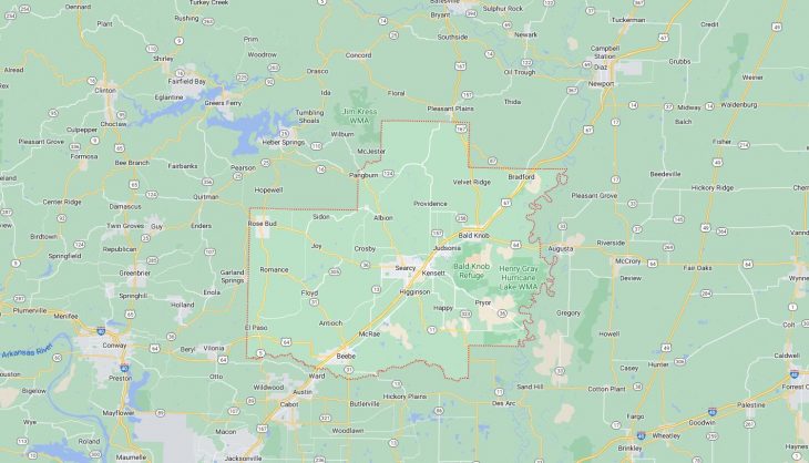
Map of Cities in White County, AR

Map of Cities in White County, AR