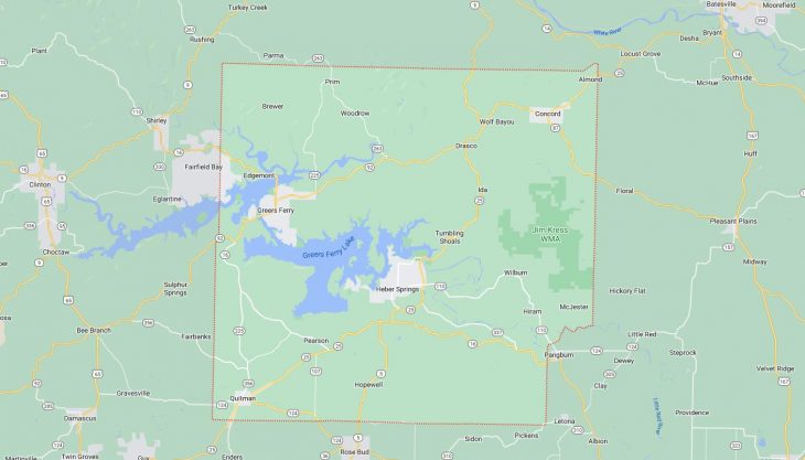
Cities and Towns in Cleburne County, Arkansas

Founded on February 20, 1883, Cleburne County is one of 75 counties in the state of Arkansas. Historically, Cleburne County was formed from White, Van Buren, and Independence counties. The city of Heber Springs is the county seat. With FIPS code of 23, Cleburne County has a population of 25,015 and area of 591.91 square miles (1,533 km²).

List of all cities in Cleburne County, AR alphabetically

City/Town Postal Code Area Code
Brewer, AR 72044 501
Concord, AR 72523 870
Drasco, AR 72530 870
Eden Isle, AR 72543 501
Edgemont, AR 72044 501
Enders, AR 72131 501
Fairbanks, AR 72131 501
Greers Ferry, AR 72067 501
Heber Springs, AR 72543 501
72545 501
Higden, AR 72067 501
Hiram, AR 72179 501
Ida, AR 72546 501
Mays Mission, AR 72545 501
Parma, AR 72044 501
Pearson, AR 72131 501
Prim, AR 72130 870
Quitman, AR 72131 501
Tumbling Shoals, AR 72581 501
Wilburn, AR 72179 501
Wolf Bayou, AR 72530 870
Woodrow, AR 72130 870

Major Cities and Towns in Cleburne County, Arkansas

Heber Springs

Area, Population, and Coordinates

  • Area: 8.9 square miles
  • Population: 7,165 (as of the last census)
  • ZIP Codes: 72543, 72545
  • Latitude and Longitude:
    • Latitude: 35.4912° N
    • Longitude: 92.0318° W

Location and History

Heber Springs is the county seat and largest city in Cleburne County, Arkansas, located near the banks of the Little Red River. The town was originally known as Sugar Loaf, named after a nearby mountain, but was renamed Heber Springs in 1910 to honor Dr. Heber Jones, a prominent physician. The discovery of the Greers Ferry Dam project in the 1960s transformed the town into a hub for tourism and recreation, particularly focused on Greers Ferry Lake, which is a major attraction for fishing, boating, and other water-related activities. Heber Springs’ location in the foothills of the Ozark Mountains adds to its appeal, offering stunning natural scenery and a relaxed, small-town atmosphere.

Major Schools and Landmarks

Heber Springs is served by the Heber Springs School District, which includes Heber Springs High School, Heber Springs Middle School, and Heber Springs Elementary School. The city is home to several key landmarks, including the Greers Ferry Dam, which is an engineering marvel and a popular site for visitors. The William Carl Garner Visitor Center offers educational exhibits on the dam and local ecology. Another significant landmark is the historic courthouse in downtown Heber Springs, which reflects the town’s long history. The annual World Championship Cardboard Boat Races on Greers Ferry Lake is a unique event that attracts participants from all over the country, celebrating creativity and community spirit.

Quitman

Area, Population, and Coordinates

  • Area: 2.1 square miles
  • Population: 762 (as of the last census)
  • ZIP Codes: 72131
  • Latitude and Longitude:
    • Latitude: 35.3770° N
    • Longitude: 92.2140° W

Location and History

Quitman is a small town located in the southern part of Cleburne County, Arkansas. The town was established in the mid-19th century and named after John A. Quitman, a prominent figure in the Mexican-American War and later Governor of Mississippi. Quitman developed as an agricultural community, with farming and livestock raising being the primary economic activities. The town’s location along the railroad contributed to its growth, making it a local center for trade and services. Quitman has maintained its rural character over the years, with a strong emphasis on community and preserving its agricultural roots.

Major Schools and Landmarks

Quitman is served by the Quitman School District, which includes Quitman High School, Quitman Middle School, and Quitman Elementary School. The town is home to several local landmarks, including the Quitman Methodist Church, which has been a central part of the community for over a century. The nearby Greers Ferry Lake and Sugar Loaf Mountain offer opportunities for outdoor recreation, including hiking, fishing, and boating, making Quitman an ideal location for those who enjoy nature. The town’s annual events, such as the Quitman Fall Festival, bring the community together to celebrate its heritage and foster a strong sense of local pride.

Greers Ferry

Area, Population, and Coordinates

  • Area: 7.0 square miles
  • Population: 891 (as of the last census)
  • ZIP Codes: 72067
  • Latitude and Longitude:
    • Latitude: 35.5745° N
    • Longitude: 92.1621° W

Location and History

Greers Ferry is a small town located on the northern shores of Greers Ferry Lake in Cleburne County, Arkansas. The town was established in the early 20th century and named after the Greers Ferry, a crossing point on the Little Red River. The construction of Greers Ferry Dam in the 1960s transformed the area, creating one of the largest lakes in Arkansas and turning Greers Ferry into a popular destination for tourism and recreation. The town’s economy is largely based on tourism, with many local businesses catering to visitors who come to enjoy the lake’s natural beauty and outdoor activities.

Major Schools and Landmarks

Greers Ferry is part of the West Side School District, with students attending West Side High School and West Side Elementary School. The town’s most notable landmark is Greers Ferry Lake, which offers some of the best fishing, boating, and water sports in the region. The surrounding Ozark Mountains provide additional opportunities for hiking and exploring the natural landscape. The nearby Narrows Park is a popular spot for picnicking and camping, offering stunning views of the lake and mountains. The town’s annual Greers Ferry Lake and Little Red River Water Carnival is a key event, celebrating the area’s natural resources with music, food, and family-friendly activities.

Fairfield Bay

Area, Population, and Coordinates

  • Area: 15.8 square miles
  • Population: 2,338 (as of the last census)
  • ZIP Codes: 72088
  • Latitude and Longitude:
    • Latitude: 35.5898° N
    • Longitude: 92.2740° W

Location and History

Fairfield Bay is a resort community located on the northern shores of Greers Ferry Lake, straddling Cleburne and Van Buren counties. The town was developed in the 1960s as a planned resort community, catering to retirees and vacationers seeking a peaceful, scenic environment. Fairfield Bay’s location on Greers Ferry Lake makes it a popular destination for boating, fishing, and other water-related activities. The town’s economy is largely based on tourism, with a range of amenities including golf courses, marinas, and hiking trails that attract visitors year-round.

Major Schools and Landmarks

Fairfield Bay is part of the Shirley School District, with students attending Shirley High School and Shirley Elementary School. The town is known for its extensive recreational facilities, including two 18-hole golf courses, Indian Hills Golf Resort and Mountain Ranch Golf Club, which are among the top-rated courses in Arkansas. The Fairfield Bay Marina offers boat rentals and lake tours, providing easy access to Greers Ferry Lake’s many recreational opportunities. The nearby Sugar Loaf Mountain, accessible by boat, offers a challenging hike with breathtaking views of the lake and surrounding area. Fairfield Bay’s annual events, such as the Surf the Bay Watersport Festival and the 4th of July Celebration, bring the community together and highlight the town’s strong connection to outdoor living and recreation.

Map of Cities in Cleburne County, AR

Map of Cities in Cleburne County, AR