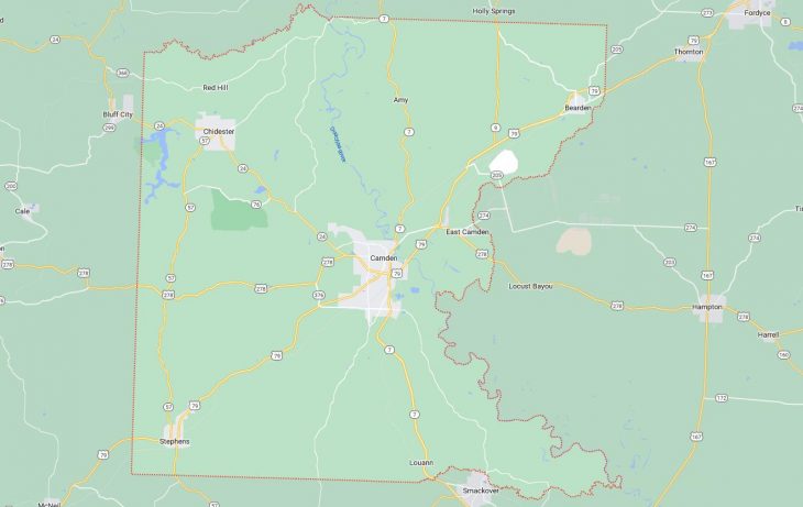
Cities and Towns in Ouachita County, Arkansas
Founded on November 29, 1842, Ouachita County is one of 75 counties in the state of Arkansas. Historically, Ouachita County was formed from Union. The city of Camden is the county seat. With FIPS code of 103, Ouachita County has a population of 22,306 and area of 739.63 square miles (1,916 km²).
List of all cities in Ouachita County, AR alphabetically
City/Town | Postal Code | Area Code |
Bearden, AR | 71720 | 870 |
Camden, AR | 71701 | 870 |
71711 | 870 | |
Chidester, AR | 71726 | 870 |
East Camden, AR | 71701 | 870 |
Louann, AR | 71751 | 870 |
Stephens, AR | 71764 | 870 |
Major Cities and Towns in Ouachita County, Arkansas
Camden
- Area: 16.5 square miles
- Population: 10,831 (2020 Census)
- ZIP Codes: 71701, 71711
- Latitude and Longitude: 33.5844° N, 92.8380° W
Location and History
Camden, the county seat of Ouachita County, Arkansas, is located in the southern part of the state along the Ouachita River. Founded in 1844, Camden quickly grew into a significant commercial hub due to its strategic location on the river, which facilitated trade and transportation. During the Civil War, Camden played a crucial role as a Confederate stronghold, and it was the site of several military engagements during the Camden Expedition of 1864. The city’s economy historically centered around cotton and timber, benefiting from the rich natural resources of the surrounding region. In the 20th century, Camden experienced industrial growth, particularly with the establishment of the Highland Industrial Park, which became a major site for defense manufacturing during and after World War II. Today, Camden is known for its rich history, charming downtown, and strong community spirit.
Major Schools and Landmarks
Camden is served by the Camden Fairview School District, which includes Camden Fairview High School, known for its academic programs and robust athletics. Major landmarks in Camden include the McCollum-Chidester House, a historic home that now operates as a museum showcasing the city’s history, particularly during the Civil War era. The Camden Downtown Historic District features numerous buildings listed on the National Register of Historic Places, reflecting the city’s 19th-century architecture. The Ouachita River provides opportunities for boating, fishing, and other recreational activities, contributing to the city’s appeal. Camden’s annual events, such as the Daffodil Festival, celebrate the city’s heritage and bring the community together for parades, music, and local crafts, making Camden a vibrant hub in Ouachita County.
East Camden
- Area: 2.8 square miles
- Population: 897 (2020 Census)
- ZIP Codes: 71701
- Latitude and Longitude: 33.6073° N, 92.7419° W
Location and History
East Camden is a small town located just northeast of Camden in Ouachita County, Arkansas. The town was established in the mid-20th century, primarily to support the operations of the Highland Industrial Park, which was developed on the site of the Shumaker Naval Ammunition Depot. The park became a significant employer in the region, particularly during the Cold War, as it housed several defense contractors. East Camden grew as a residential community for workers employed at the industrial park and related facilities. Over the years, the town has remained closely tied to the defense industry, with many of its residents working in various manufacturing and engineering roles. Despite its small size, East Camden has played a crucial role in the local economy, contributing to the broader economic stability of Ouachita County.
Major Schools and Landmarks
East Camden is part of the Harmony Grove School District, with students attending Harmony Grove High School, known for its strong academic programs and extracurricular activities. The town is closely associated with the Highland Industrial Park, which remains a major landmark and economic driver in the area. The park houses several defense contractors and manufacturing facilities, contributing to the town’s identity as a hub for industry and innovation. East Camden is also located near the Ouachita River, providing residents with opportunities for outdoor recreation, including fishing, boating, and hiking. The town’s annual events, such as community picnics and holiday celebrations, reflect its close-knit atmosphere and the strong bonds among its residents. East Camden’s industrial heritage, combined with its scenic surroundings, makes it a unique and vital part of Ouachita County.
Stephens
- Area: 1.9 square miles
- Population: 699 (2020 Census)
- ZIP Codes: 71764
- Latitude and Longitude: 33.4165° N, 93.0682° W
Location and History
Stephens is a small town located in the southern part of Ouachita County, Arkansas. Established in the late 19th century, Stephens grew rapidly in the early 20th century due to the discovery of oil in the region. The town became a bustling center for the oil industry, with numerous wells and related businesses contributing to its growth and prosperity. During the oil boom, Stephens attracted workers from across the country, leading to a period of rapid development and economic expansion. Over time, as the oil industry declined, Stephens transitioned to a quieter, more residential community, but its history as an oil town remains an integral part of its identity. Today, Stephens is known for its small-town charm and rich historical legacy.
Major Schools and Landmarks
Stephens is part of the Stephens School District, which includes Stephens High School, known for its community-oriented approach and involvement in local activities. Significant landmarks in Stephens include the Stephens Historical Museum, which preserves artifacts and exhibits related to the town’s oil boom era, providing a glimpse into its past as a thriving industrial hub. The town’s historic downtown area features several buildings from the early 20th century, reflecting the architectural style of the period. Stephens is also located near several natural areas, offering opportunities for outdoor activities such as hunting, fishing, and hiking. The town’s annual events, such as the Oil Boom Festival, celebrate its history and bring the community together for a day of fun and reflection on its rich heritage. Stephens’ connection to the oil industry, combined with its rural setting, makes it a unique and historically significant town in Ouachita County.
Bearden
- Area: 1.5 square miles
- Population: 760 (2020 Census)
- ZIP Codes: 71720
- Latitude and Longitude: 33.7249° N, 92.6154° W
Location and History
Bearden is a small town located in the northern part of Ouachita County, Arkansas. The town was established in the late 19th century and grew as a result of the expansion of the timber industry, which was a major economic driver in the region. Bearden’s location along the railroad made it an important shipping point for timber and related products, contributing to its early growth. The town developed a strong sense of community, with many of its residents involved in logging, sawmilling, and other forestry-related activities. Over the years, Bearden has retained its small-town character and close-knit community, with a strong emphasis on family and tradition. The town’s history is closely tied to the land, with the surrounding forests playing a central role in its development.
Major Schools and Landmarks
Bearden is part of the Bearden School District, with Bearden High School serving the community’s educational needs. The school is known for its academic programs and active participation in sports and extracurricular activities. Major landmarks in Bearden include the historic Bearden Depot, which serves as a reminder of the town’s past as a key transportation hub for the timber industry. The town is also home to several historic churches that reflect its strong religious heritage. The nearby Moro Bay State Park, located along the Ouachita River, offers opportunities for fishing, boating, and camping, making it a popular destination for outdoor enthusiasts. Bearden’s annual events, such as the Bearden Fall Festival, bring residents together to celebrate their community and its rich history. The town’s rural charm, historic sites, and strong community bonds make Bearden a quintessential example of small-town life in Ouachita County.
Louann
- Area: 0.8 square miles
- Population: 137 (2020 Census)
- ZIP Codes: 71751
- Latitude and Longitude: 33.3962° N, 92.8358° W
Location and History
Louann is a small town located in the southern part of Ouachita County, Arkansas. The town was established in the early 20th century, largely as a result of the discovery of oil in the region. Louann quickly became a bustling community as oil workers and their families moved in, and the town developed around the oil industry, with numerous wells and related businesses contributing to its growth. The town’s name is believed to have been derived from the names of two women, Lou and Ann, who were prominent in the early community. Over time, as the oil industry declined, Louann transitioned to a quieter, more residential community, but its history as an oil town remains a significant part of its identity. Today, Louann is a small, peaceful town with a rich history and a strong sense of community.
Major Schools and Landmarks
Louann is part of the Camden Fairview School District, with students attending schools in nearby Camden. The town itself is small, with few commercial establishments, but it is surrounded by rich natural landscapes that provide opportunities for outdoor recreation. Significant landmarks in Louann include several historic oil wells and derricks that serve as reminders of the town’s past as a key player in the oil industry. The nearby Ouachita River offers opportunities for fishing, boating, and other outdoor activities. Louann’s annual community events, such as local fairs and church gatherings, help maintain the town’s close-knit atmosphere and celebrate its history. The town’s rural charm, historic sites, and strong community bonds make Louann a unique and historically significant part of Ouachita County.
Chidester
- Area: 1.8 square miles
- Population: 283 (2020 Census)
- ZIP Codes: 71726
- Latitude and Longitude: 33.7037° N, 93.0224° W
Location and History
Chidester is a small town located in the northern part of Ouachita County, Arkansas. The town was established in the late 19th century and named after a prominent local family. Chidester developed primarily as a farming community, with agriculture being the mainstay of the local economy. The town’s location along the railroad provided a vital transportation link for farmers to ship their products to larger markets. Over the years, Chidester has maintained its rural character and small-town atmosphere, with a close-knit community that values its history and traditions. The town’s history is closely tied to the land, with many of its residents being descendants of the original settlers who farmed the area for generations.
Major Schools and Landmarks
Chidester is part of the Camden Fairview School District, with students attending schools in nearby Camden. The town itself is small, with a few local businesses and a rural setting that offers a peaceful lifestyle. Significant landmarks in Chidester include the historic Chidester Methodist Church, which has been a cornerstone of the community for many years. The town is also near the Poison Springs Battleground State Park, a site of a Civil War battle that is now a preserved historical landmark, offering educational opportunities and outdoor recreation. Chidester’s annual community events, such as local picnics and church gatherings, help maintain the town’s close-knit atmosphere and celebrate its agricultural heritage. The town’s rural charm, historic sites, and strong community bonds make Chidester a quintessential example of small-town life in Ouachita County.