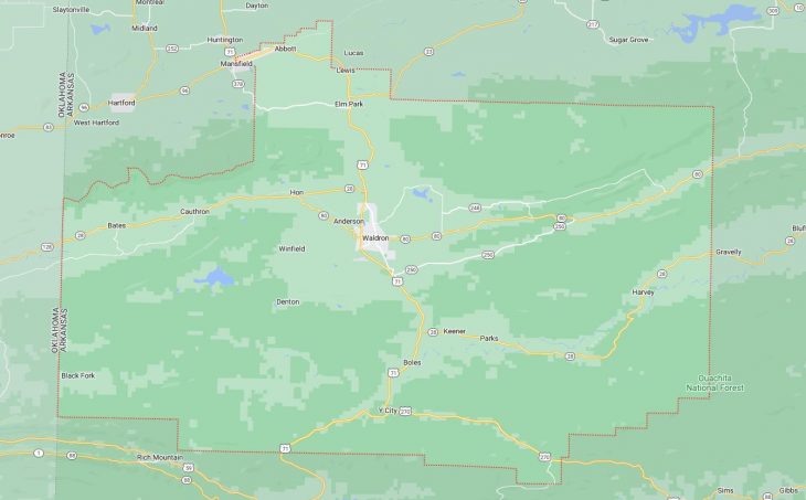
Cities and Towns in Scott County, Arkansas

Founded on November 5, 1833, Scott County is one of 75 counties in the state of Arkansas. Historically, Scott County was formed from Crawford and Pope counties. The city of Waldron is the county seat. With FIPS code of 127, Scott County has a population of 9,822 and area of 898.09 square miles (2,326 km²).

List of all cities in Scott County, AR alphabetically

City/Town Postal Code Area Code
Abbott, AR 72944 479
Bates, AR 72958 479
Boles, AR 72926 479
Harvey, AR 72841 479
Mansfield, AR 72944 479
Parks, AR 72950 479
Waldron, AR 72958 479

Major Cities and Towns in Scott County, Arkansas

Waldron

  • Area: 5.4 square miles
  • Population: 3,372 (2020 Census)
  • ZIP Codes: 72958
  • Latitude and Longitude: 34.8987° N, 94.0907° W

Location and History

Waldron, the county seat of Scott County, is located in the western part of Arkansas, nestled in the Ouachita Mountains. The city was established in 1845 and named after William Grandison Waldron, a prominent early settler and surveyor. Waldron quickly became a regional hub due to its strategic location along the Poteau River and its role as a center for trade and agriculture. During the Civil War, Waldron was occupied by both Confederate and Union forces at different times, reflecting its strategic importance. The city’s economy has traditionally been based on agriculture, timber, and livestock, with the fertile land around Waldron supporting a variety of crops. Over time, Waldron has grown into a small but vibrant community that serves as the cultural and economic center of Scott County. The city’s location near the Ouachita National Forest also makes it a gateway for outdoor recreation.

Major Schools and Landmarks

Waldron is served by the Waldron School District, which includes Waldron High School, Waldron Middle School, and Waldron Elementary School. The schools are known for their strong academic programs and active participation in sports and extracurricular activities. Major landmarks in Waldron include the Scott County Courthouse, a historic building that dates back to 1934 and reflects the city’s rich history. The Waldron City Park, which features walking trails, playgrounds, and a community center, is a popular gathering place for residents. The nearby Ouachita National Forest offers numerous opportunities for hiking, camping, and fishing, making Waldron a hub for outdoor enthusiasts. The annual Turkey Track Bluegrass Festival, held just outside of Waldron, attracts music lovers from across the region and highlights the city’s cultural ties to traditional American music.

Mansfield

  • Area: 2.5 square miles
  • Population: 1,109 (2020 Census)
  • ZIP Codes: 72944
  • Latitude and Longitude: 35.0603° N, 94.2413° W

Location and History

Mansfield, straddling the border between Scott and Sebastian counties, is a small city with a rich history rooted in agriculture and coal mining. Founded in the late 19th century, Mansfield grew rapidly due to the development of the railroad, which facilitated the transportation of coal and agricultural products. The city was named after Captain Henry Mansfield, a prominent figure in the region’s early history. During its peak, Mansfield was a bustling town with a strong economy based on mining, farming, and timber. Over the years, as mining activities declined, the town shifted towards a more agricultural and residential focus. Despite its small size, Mansfield has maintained its historical charm and serves as a peaceful community with strong ties to its past.

Major Schools and Landmarks

Mansfield is part of the Mansfield School District, which includes Mansfield High School, Mansfield Middle School, and Mansfield Elementary School. The schools are central to the community, offering a range of academic and extracurricular programs. Significant landmarks in Mansfield include the historic Mansfield Cemetery, where many of the town’s early settlers are buried, and the Old Rock Jail, a small but historically significant building that reflects the town’s past. The nearby James Fork Creek provides opportunities for fishing and outdoor activities, while the surrounding countryside is ideal for hiking and exploring. The town’s annual events, such as the Mansfield Pioneer Days, celebrate its rich heritage and bring the community together for festivities that honor the area’s history and traditions.

Boles

  • Area: Not incorporated
  • Population: Included within Scott County’s population
  • ZIP Codes: 72926
  • Latitude and Longitude: 34.7554° N, 94.0894° W

Location and History

Boles is a small, unincorporated community located in the southern part of Scott County, Arkansas. The town was established in the late 19th century, primarily as a farming and logging community. Boles has always been a small, rural area with a close-knit community, where agriculture remains the primary economic activity. The town’s history is deeply tied to the surrounding natural resources, with the nearby Ouachita National Forest providing both a source of income and a beautiful backdrop for the community. Over the years, Boles has remained a quiet and peaceful place, known for its scenic landscapes and the strong community bonds among its residents.

Major Schools and Landmarks

Boles is served by the Waldron School District, with children attending schools in nearby Waldron. While Boles is small and does not have many formal landmarks, its location near the Ouachita National Forest makes it a prime area for outdoor activities such as hiking, hunting, and fishing. The community’s proximity to the Fourche La Fave River also offers opportunities for water-based recreation. The town itself is characterized by its rural charm, with open fields, farmlands, and forests creating a picturesque environment. Boles may be small, but it exemplifies the quiet, rural lifestyle that is central to the identity of many communities in Scott County.

Parks

  • Area: Not incorporated
  • Population: Included within Scott County’s population
  • ZIP Codes: 72950
  • Latitude and Longitude: 34.8073° N, 94.0268° W

Location and History

Parks is a small, unincorporated community in Scott County, Arkansas, located in the heart of the Ouachita Mountains. The town was established in the late 19th century as a small farming community. Parks has always been a small, rural town, with its economy primarily based on agriculture, including cattle farming and timber production. The town’s name reflects its natural surroundings, as it is located near several protected areas within the Ouachita National Forest. The community has remained small and close-knit, with residents taking pride in their rural lifestyle and the natural beauty that surrounds them. Parks is a typical example of the many small, unincorporated communities that dot the landscape of Scott County, offering a peaceful and quiet way of life.

Major Schools and Landmarks

Parks is served by the Waldron School District, with students attending schools in nearby Waldron. The community is known for its proximity to the Ouachita National Forest, which offers a wealth of outdoor recreational opportunities, including hiking, fishing, and camping. Significant landmarks in the area include the Parks Cemetery, which holds historical significance as the final resting place for many of the area’s early settlers. The Fourche La Fave River, which flows nearby, is a popular spot for fishing and enjoying the natural beauty of the region. Although Parks is small, its residents are deeply connected to the land and the natural environment, making it a unique and tranquil place within Scott County.

Nola

  • Area: Not incorporated
  • Population: Included within Scott County’s population
  • ZIP Codes: 72863
  • Latitude and Longitude: 34.8284° N, 93.9924° W

Location and History

Nola is an unincorporated community located in the northeastern part of Scott County, Arkansas. The town was established in the early 20th century and was named after a local family. Nola has always been a small, rural community, with its economy largely centered around agriculture and forestry. The town’s location in the Ouachita Mountains has also made it a place of natural beauty, with rolling hills and dense forests surrounding the area. Nola’s history is closely tied to the land, with generations of families farming the same plots of land for decades. While the town has never grown significantly in size, it has maintained a strong sense of community and a connection to its rural roots.

Major Schools and Landmarks

Nola is part of the Waldron School District, with students attending schools in Waldron. The community is known for its scenic landscapes and rural charm, with the nearby Ouachita National Forest providing ample opportunities for outdoor activities such as hiking, hunting, and fishing. The town itself is small and does not have many formal landmarks, but its residents take pride in the natural beauty that surrounds them. The community’s annual gatherings and events, such as local fairs and picnics, reflect the close-knit nature of Nola and its commitment to preserving the rural lifestyle that defines the town. Nola’s quiet, peaceful environment and strong community bonds make it a quintessential example of rural life in Scott County.

Map of Cities in Scott County, AR

Map of Cities in Scott County, AR