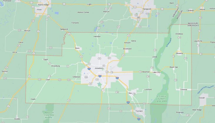
Cities and Towns in Craighead County, Arkansas

Founded on February 19, 1859, Craighead County is one of 75 counties in the state of Arkansas. Historically, Craighead County was formed from Mississippi, Greene, and Poinsett counties. The city of Jonesboro, Lake City is the county seat. With FIPS code of 31, Craighead County has a population of 112,218 and area of 712.98 square miles (1,847 km²).

List of all cities in Craighead County, AR alphabetically

City/Town Postal Code Area Code
Bay, AR 72411 870
Black Oak, AR 72414 870
Bono, AR 72416 870
Brookland, AR 72417 870
Caraway, AR 72419 870
Cash, AR 72421 870
Egypt, AR 72427 870
Jonesboro, AR 72401 870
72402 870
72403 870
72404 870
Lake City, AR 72437 870
Monette, AR 72447 870
Saint University, AR 72467 870
72467 870

Major Cities and Towns in Craighead County, Arkansas

Jonesboro

Area, Population, and Coordinates

  • Area: 80.5 square miles
  • Population: 78,576 (as of the last census)
  • ZIP Codes: 72401, 72402, 72403, 72404
  • Latitude and Longitude:
    • Latitude: 35.8423° N
    • Longitude: 90.7043° W

Location and History

Jonesboro is the largest city in Craighead County, Arkansas, and serves as one of the county’s two seats of government. The city is located in the northeastern part of the state and has been a central hub of commerce, education, and healthcare in the region. Jonesboro was established in 1859, named after State Senator William A. Jones, and quickly grew as a key agricultural center, particularly in cotton production. The arrival of the railroad in the late 19th century further spurred its growth, making it a significant trading and transportation hub. Today, Jonesboro is known for its dynamic economy, which includes manufacturing, retail, and education, with Arkansas State University playing a vital role in the city’s cultural and economic life.

Major Schools and Landmarks

Jonesboro is served by the Jonesboro Public Schools, which includes Jonesboro High School, several middle schools, and elementary schools. Arkansas State University, a major educational institution, is also located in the city, offering a wide range of undergraduate and graduate programs. Key landmarks in Jonesboro include the Craighead Forest Park, a popular recreational area with trails, a lake, and picnic spots, and the ASU Museum, which features exhibits on the natural and cultural history of Northeast Arkansas. The city also hosts the annual Jonesboro BBQ Festival, attracting visitors for food, music, and community activities.

Lake City

Area, Population, and Coordinates

  • Area: 3.5 square miles
  • Population: 2,326 (as of the last census)
  • ZIP Codes: 72437
  • Latitude and Longitude:
    • Latitude: 35.8170° N
    • Longitude: 90.4429° W

Location and History

Lake City is a small town located in the eastern part of Craighead County, Arkansas, along the banks of the St. Francis River. The town was established in the late 19th century and named for its proximity to the nearby lakes and the river. Lake City developed as a farming community, with agriculture, particularly rice and soybean farming, being the backbone of its economy. The town’s location near the river made it a natural site for transportation and trade, contributing to its growth. Today, Lake City remains a small, rural community with a strong connection to its agricultural roots.

Major Schools and Landmarks

Lake City is served by the Riverside School District, which includes Riverside High School, Riverside Junior High, and several elementary schools. The town is home to several local landmarks, including the Lake City Courthouse, which reflects the town’s historical significance as a center of government and trade. The nearby St. Francis River provides opportunities for fishing, boating, and other outdoor activities, making it a popular destination for residents and visitors alike. Lake City’s annual community events, such as the Lake City Fall Festival, bring residents together to celebrate their heritage and foster a strong sense of community spirit.

Monette

Area, Population, and Coordinates

  • Area: 1.5 square miles
  • Population: 1,501 (as of the last census)
  • ZIP Codes: 72447
  • Latitude and Longitude:
    • Latitude: 35.8925° N
    • Longitude: 90.3429° W

Location and History

Monette is a small town located in the eastern part of Craighead County, Arkansas. The town was founded in the early 20th century and named after a local landowner. Monette developed as an agricultural community, with cotton and soybean farming being the primary economic activities. The town’s location along the railroad made it an important center for shipping agricultural products, contributing to its growth in the early 20th century. Monette has maintained its rural character and close-knit community, with a strong focus on preserving its agricultural heritage.

Major Schools and Landmarks

Monette is part of the Buffalo Island Central School District, with students attending Buffalo Island Central High School, Junior High, and Elementary Schools. The town is home to several local landmarks, including the Monette United Methodist Church, which has been a central part of the community for many years. The surrounding farmland and natural areas provide opportunities for hunting, fishing, and other outdoor activities, reflecting Monette’s connection to the land. The town’s annual events, such as the Monette Christmas Parade, bring residents together to celebrate their heritage and foster a strong sense of community spirit.

Brookland

Area, Population, and Coordinates

  • Area: 5.5 square miles
  • Population: 3,980 (as of the last census)
  • ZIP Codes: 72417
  • Latitude and Longitude:
    • Latitude: 35.9006° N
    • Longitude: 90.5831° W

Location and History

Brookland is a growing town located in the northeastern part of Craighead County, Arkansas, just a few miles northeast of Jonesboro. The town was established in the early 20th century and developed as an agricultural community. Brookland’s proximity to Jonesboro has made it an attractive location for new residents, leading to significant growth in recent years. The town’s economy has diversified, with a mix of agriculture, retail, and residential development contributing to its expansion. Brookland has maintained its small-town charm while embracing modern amenities and infrastructure improvements.

Major Schools and Landmarks

Brookland is served by the Brookland School District, which includes Brookland High School, Brookland Junior High, and several elementary schools. The town is home to several local landmarks, including the Brookland Baptist Church, which has been a central part of the community for many years. The nearby Crowley’s Ridge offers opportunities for hiking, camping, and other outdoor activities, making it a popular destination for residents and visitors alike. Brookland’s annual community events, such as the Brookland Christmas Festival, bring residents together to celebrate their heritage and foster a strong sense of community spirit.

Map of Cities in Craighead County, AR

Map of Cities in Craighead County, AR