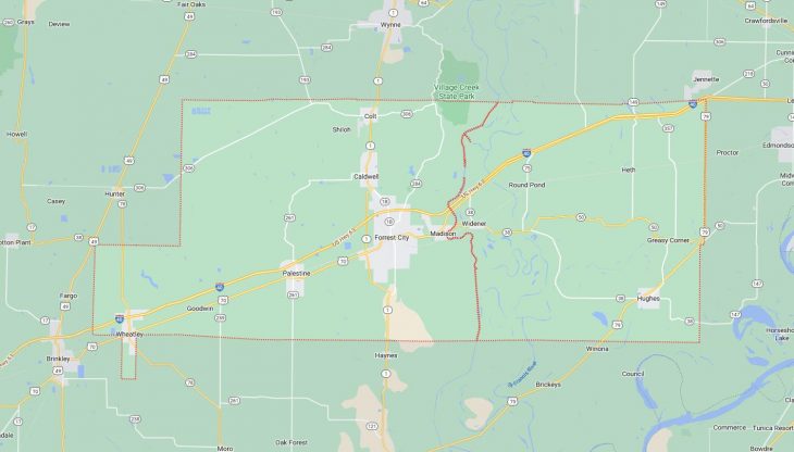
Cities and Towns in Saint Francis County, Arkansas

Founded on October 13, 1827, St. Francis County is one of 75 counties in the state of Arkansas. Historically, St. Francis County was formed from Formed from Phillips County. The city of Forrest City is the county seat. With FIPS code of 123, St. Francis County has a population of 22,739 and area of 642.40 square miles (1,664 km²).

List of all cities in Saint Francis County, AR alphabetically

City/Town Postal Code Area Code
Blackfish, AR 72346 870
Caldwell, AR 72322 870
Colt, AR 72326 870
Forrest City, AR 72335 870
72336 870
Goodwin, AR 72340 870
Heth, AR 72346 870
Horseshoe Lake, AR 72348 870
Hughes, AR 72348 870
Madison, AR 72359 870
Palestine, AR 72372 870
Round Pond, AR 72394 870
Wheatley, AR 72392 870
Widener, AR 72394 870

Major Cities and Towns in Saint Francis County, Arkansas

Forrest City

  • Area: 16.4 square miles
  • Population: 13,123 (2020 Census)
  • ZIP Codes: 72335, 72336
  • Latitude and Longitude: 35.0087° N, 90.7893° W

Location and History

Forrest City, the county seat of Saint Francis County, is located in eastern Arkansas, roughly halfway between Little Rock and Memphis. The city was founded in 1870 by the Confederate General Nathan Bedford Forrest, who established a railroad construction camp in the area. Originally a hub for the construction of the Memphis and Little Rock Railroad, Forrest City quickly grew into a thriving community due to its strategic location along major transportation routes. The city developed as a center for agriculture, particularly cotton, which played a significant role in its early economy. Over the years, Forrest City expanded its economic base to include manufacturing, retail, and services, making it a key regional center in eastern Arkansas. The city’s history is deeply connected to the development of transportation and agriculture in the region, and it remains an important hub for commerce and culture in Saint Francis County.

Major Schools and Landmarks

Forrest City is served by the Forrest City School District, which includes Forrest City High School, Forrest City Junior High, and several elementary schools. The district is known for its strong academic programs and active participation in sports and extracurricular activities. Major landmarks in Forrest City include the St. Francis County Courthouse, a historic building that reflects the city’s long-standing importance as a regional center. The Forrest City Downtown Historic District features several well-preserved buildings that date back to the early 20th century, offering a glimpse into the city’s past. The nearby Village Creek State Park, one of the largest parks in Arkansas, provides opportunities for hiking, fishing, and camping, making it a popular destination for outdoor enthusiasts. Additionally, the Forrest City Civic Center hosts various community events, contributing to the city’s vibrant cultural scene.

Madison

  • Area: 1.2 square miles
  • Population: 658 (2020 Census)
  • ZIP Codes: 72359
  • Latitude and Longitude: 35.0187° N, 90.7298° W

Location and History

Madison is a small town located just west of Forrest City in Saint Francis County, Arkansas. The town was established in the late 19th century and named after the fourth President of the United States, James Madison. Madison developed as a farming community, with agriculture being the primary economic activity for much of its history. The town’s location along the St. Francis River provided fertile land for farming, particularly cotton and other cash crops. Despite its small size, Madison has a rich history and has served as a quiet, rural community throughout its existence. Over the years, the town has maintained its agricultural roots while gradually adapting to modern changes, making it a peaceful place to live with a strong sense of community.

Major Schools and Landmarks

Madison is part of the Forrest City School District, with students attending schools in nearby Forrest City. The town itself is primarily residential and agricultural, with few major landmarks. However, its proximity to the St. Francis River offers opportunities for fishing and other outdoor activities. Madison’s most significant landmarks are its historic churches, which reflect the town’s strong community ties and its role as a center for local worship and gatherings. The nearby Village Creek State Park is also easily accessible to residents, providing additional recreational opportunities. Madison’s annual community events, such as local fairs and church gatherings, help to maintain the town’s close-knit atmosphere and rural charm.

Hughes

  • Area: 2.0 square miles
  • Population: 1,124 (2020 Census)
  • ZIP Codes: 72348
  • Latitude and Longitude: 34.9512° N, 90.4717° W

Location and History

Hughes is a small city located in the southeastern part of Saint Francis County, Arkansas. The town was established in the early 20th century and named after a local landowner. Hughes grew as an agricultural community, with farming being the primary economic driver. The fertile lands surrounding Hughes made it an ideal location for the cultivation of cotton, soybeans, and other crops. Over time, Hughes developed a close-knit community centered around agriculture, with generations of families farming the same lands for decades. The town has seen changes in population and economy over the years, particularly as the mechanization of agriculture reduced the demand for labor. However, Hughes remains a proud and resilient community with a deep connection to its agricultural heritage.

Major Schools and Landmarks

Hughes is served by the Hughes School District, which includes Hughes High School. However, due to population changes, students may now attend schools in neighboring districts. The town features several churches that serve as community hubs, reflecting the strong religious roots of the area. Hughes is also known for its historic downtown area, where several buildings from the early 20th century still stand, offering a glimpse into the town’s past. The nearby Mississippi River provides opportunities for fishing and other recreational activities. Hughes hosts an annual fall festival that celebrates its agricultural heritage, bringing together residents for a day of music, food, and community activities, highlighting the town’s enduring spirit and commitment to preserving its traditions.

Colt

  • Area: 1.0 square miles
  • Population: 328 (2020 Census)
  • ZIP Codes: 72326
  • Latitude and Longitude: 35.1267° N, 90.8101° W

Location and History

Colt is a small town located in northern Saint Francis County, Arkansas. The town was established in the early 20th century, primarily as a farming community. Named after a local family, Colt developed as a modest rural town with agriculture at its core. The town’s location near the L’Anguille River provided fertile soil for farming, particularly for cotton and other crops that were vital to the local economy. Over the years, Colt has remained a small, close-knit community with deep agricultural roots. Despite its size, the town has managed to preserve its rural character and maintain a strong sense of community among its residents. Colt’s history is reflective of many small towns in Arkansas, where agriculture remains the backbone of the local economy.

Major Schools and Landmarks

Colt is part of the Forrest City School District, with students attending schools in nearby Forrest City. The town itself is largely residential, with several farms dotting the surrounding landscape. Notable landmarks in Colt include the Colt Cemetery, which serves as a historical site and the final resting place for many of the town’s early settlers. The town is also located near the L’Anguille River, offering opportunities for fishing and outdoor activities. Colt’s annual community events, such as local picnics and fairs, reflect the town’s rural heritage and the strong bonds among its residents. The town’s quiet, peaceful atmosphere makes it a quintessential example of small-town life in Saint Francis County.

Palestine

  • Area: 3.3 square miles
  • Population: 681 (2020 Census)
  • ZIP Codes: 72372
  • Latitude and Longitude: 34.9723° N, 90.8970° W

Location and History

Palestine is a small city located in western Saint Francis County, Arkansas, along the L’Anguille River. The town was established in the late 19th century and was named after the biblical land of Palestine. Palestine developed as a farming community, with agriculture being the primary economic activity. The town’s location along the railroad helped spur growth, making it a local hub for the transport of agricultural products. Throughout its history, Palestine has remained a small, rural town with a strong emphasis on community and tradition. The town’s population has remained relatively stable over the years, with agriculture continuing to play a central role in its economy.

Major Schools and Landmarks

Palestine is served by the Palestine-Wheatley School District, which includes Palestine-Wheatley High School. The schools are an important part of the community, offering a range of academic and extracurricular programs. Major landmarks in Palestine include the historic Palestine Depot, which reflects the town’s early connection to the railroad, and several churches that serve as community centers. The town is also located near the L’Anguille River, providing opportunities for fishing and other outdoor activities. Palestine’s annual events, such as the fall festival and holiday parades, bring the community together and celebrate the town’s rich history and agricultural heritage. The town’s quiet streets, historic buildings, and strong community spirit make it a charming example of rural life in Saint Francis County.

Map of Cities in Saint Francis County, AR

Map of Cities in Saint Francis County, AR