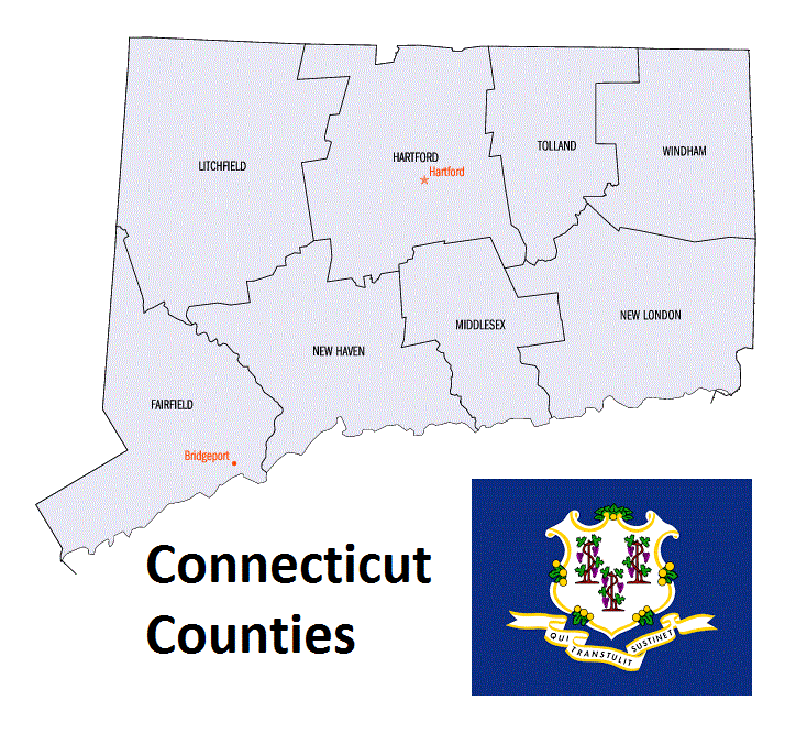
Connecticut Counties. List Alphabetically (and by Population)
How many counties are there in Connecticut? As of 2024, there are a total of 8 counties in the state of Connecticut. Among them, Fairfield County is the oldest one (established in 1666) while Middlesex County is the youngest (established in 1785). With population of 916,829, Fairfield County is the most populated. The biggest county by land area is Litchfield County (2,383 km²) and the smallest is Middlesex County (956 km²).
Largest Counties in Connecticut
1. Litchfield County
County Seat: Litchfield (Unofficial)
- Area: 920 square miles
- Population: Approximately 185,186 (2020 census)
- Area Codes: 860
- Latitude: 41.7473° N
- Longitude: 73.1887° W
Location and History
Litchfield County is the largest county by area in Connecticut, located in the northwestern corner of the state. Established in 1751, it is known for its rolling hills, rural charm, and historic towns. The area was originally inhabited by Native American tribes, including the Mahican and the Paugussett. European settlement began in the early 18th century, and the county quickly became a hub for agriculture, iron production, and later, tourism. Litchfield, often considered the unofficial county seat, was once a prominent center of learning, home to the Litchfield Law School, one of the first law schools in the United States.
Major Highways and Landmarks
Litchfield County is traversed by U.S. Routes 7, 202, and 44, providing connections to neighboring states and major cities. The county is known for its natural beauty, with significant landmarks including the Appalachian Trail, which runs through the county, and Mohawk Mountain, a popular destination for skiing. The Litchfield Historic District, with its well-preserved 18th-century architecture, and the White Memorial Conservation Center, a large nature preserve, are also notable attractions. Additionally, Lake Waramaug and Bantam Lake offer opportunities for boating, fishing, and outdoor recreation.
2. Hartford County
County Seat: Hartford (Unofficial)
- Area: 751 square miles
- Population: Approximately 899,498 (2020 census)
- Area Codes: 860, 959
- Latitude: 41.7670° N
- Longitude: 72.6784° W
Location and History
Hartford County is located in north-central Connecticut and is home to Hartford, the state capital. Established in 1666, it is one of the original four counties created in the Connecticut Colony. Hartford County played a significant role in early American history, particularly during the colonial period and the American Revolution. The city of Hartford became a major center for commerce, insurance, and manufacturing, earning the nickname “The Insurance Capital of the World.” The county’s rich history is reflected in its many historic buildings, museums, and institutions of higher learning.
Major Highways and Landmarks
Hartford County is served by several major highways, including Interstates 84 and 91, which intersect in Hartford, providing access to Boston, New York, and other major cities. Notable landmarks include the Mark Twain House & Museum, the former home of the famous American author, and the Connecticut State Capitol, an architectural masterpiece located in Bushnell Park. The Wadsworth Atheneum, the oldest public art museum in the United States, is also located in Hartford. The county is home to the University of Hartford and Trinity College, both of which contribute to the region’s cultural and educational landscape.
3. New Haven County
County Seat: New Haven (Unofficial)
- Area: 606 square miles
- Population: Approximately 864,835 (2020 census)
- Area Codes: 203, 475
- Latitude: 41.3083° N
- Longitude: 72.9279° W
Location and History
New Haven County is located along the southern coast of Connecticut, bordering Long Island Sound. Established in 1666, it was one of the original counties in the Connecticut Colony. New Haven, the largest city and de facto county seat, is known for being the home of Yale University, one of the most prestigious universities in the world. The county has a rich history, including its role as the co-capital of Connecticut until 1875 and as a center for manufacturing during the Industrial Revolution. New Haven County’s economy has diversified over time, with education, healthcare, and biotechnology playing significant roles.
Major Highways and Landmarks
New Haven County is intersected by Interstate 95, a major north-south highway that runs along the East Coast, and Interstate 91, which connects New Haven to Hartford and points north. Key landmarks include Yale University, with its historic campus and renowned museums such as the Yale University Art Gallery and the Peabody Museum of Natural History. The New Haven Green, a historic park in the center of the city, has been a focal point for the community since the 17th century. The county also features scenic coastal areas, including Lighthouse Point Park and the Thimble Islands.
4. Fairfield County
County Seat: Bridgeport (Unofficial)
- Area: 837 square miles
- Population: Approximately 957,419 (2020 census)
- Area Codes: 203, 475
- Latitude: 41.1865° N
- Longitude: 73.1952° W
Location and History
Fairfield County is located in the southwestern corner of Connecticut, bordering New York State and Long Island Sound. Established in 1666, it is part of the New York metropolitan area and includes some of the wealthiest communities in the United States, such as Greenwich, New Canaan, and Darien. The county has a long history of affluence and influence, dating back to its early days as a center for shipping, trade, and industry. Today, Fairfield County is known for its vibrant economy, high quality of life, and proximity to New York City, making it a desirable location for both residents and businesses.
Major Highways and Landmarks
Fairfield County is served by several major highways, including Interstate 95, which runs along the coast, and the Merritt Parkway (Route 15), known for its scenic beauty and historic bridges. The county is home to significant landmarks such as the Maritime Aquarium at Norwalk, the Bruce Museum in Greenwich, and the Beardsley Zoo in Bridgeport, Connecticut’s only zoo. The county’s picturesque coastline offers numerous parks and beaches, including Sherwood Island State Park, Connecticut’s first state park. Additionally, Fairfield County’s historic towns, with their well-preserved colonial architecture, attract visitors interested in history and culture.
5. Windham County
County Seat: Willimantic (Unofficial)
- Area: 521 square miles
- Population: Approximately 116,418 (2020 census)
- Area Codes: 860
- Latitude: 41.7106° N
- Longitude: 72.2086° W
Location and History
Windham County is located in the northeastern part of Connecticut, often referred to as the “Quiet Corner” due to its rural character and low population density. Established in 1726, the county has a history rooted in agriculture, textiles, and small-town life. Willimantic, the largest city in the county, became a major center for textile manufacturing in the 19th century, earning the nickname “Thread City.” The county is known for its scenic countryside, historic villages, and a slower pace of life, making it a popular destination for those seeking a retreat from urban areas.
Major Highways and Landmarks
Windham County is accessible via U.S. Route 6, which runs east-west through the region, and State Routes 14 and 32. Notable landmarks include the Connecticut Eastern Railroad Museum in Willimantic, which preserves the county’s railroad history, and the Roseland Cottage in Woodstock, a National Historic Landmark known for its Gothic Revival architecture. The county is also home to several state parks and forests, including Natchaug State Forest and Bigelow Hollow State Park, offering hiking, fishing, and other outdoor activities. The historic Windham Textile & History Museum provides insights into the county’s industrial past.
6. New London County
County Seat: New London (Unofficial)
- Area: 666 square miles
- Population: Approximately 268,555 (2020 census)
- Area Codes: 860
- Latitude: 41.3557° N
- Longitude: 72.0995° W
Location and History
New London County is located in southeastern Connecticut, along the Long Island Sound coast and the mouth of the Thames River. Established in 1666, it was one of the four original counties in Connecticut. New London, the largest city and de facto county seat, has a rich maritime history, serving as a major port during the colonial period and the American Revolution. The county is also home to the U.S. Coast Guard Academy and the Naval Submarine Base New London, making it a key location for the U.S. military. The county’s economy has traditionally been based on maritime activities, manufacturing, and defense.
Major Highways and Landmarks
New London County is intersected by Interstate 95, which runs along the coast, and U.S. Route 1, which parallels the interstate. Significant landmarks include Mystic Seaport, the largest maritime museum in the United States, and Mystic Aquarium, known for its research and conservation programs. The county also boasts historic sites such as Fort Trumbull and the Nathan Hale Schoolhouse. The Mohegan Sun and Foxwoods Resort Casinos, two of the largest casinos in the world, are located in the county, attracting millions of visitors annually. The scenic coastal towns of Stonington and Old Lyme offer picturesque views and historic charm.
7. Middlesex County
County Seat: Middletown (Unofficial)
- Area: 439 square miles
- Population: Approximately 164,245 (2020 census)
- Area Codes: 860
- Latitude: 41.5623° N
- Longitude: 72.6506° W
Location and History
Middlesex County is located in central Connecticut, along the Connecticut River and Long Island Sound. Established in 1785, it is named after Middlesex, England. Middletown, the largest city and de facto county seat, was originally known as a major port on the Connecticut River and later developed into an industrial center. The county has a rich history that includes early Native American settlements, colonial development, and a strong maritime tradition. Today, Middlesex County is known for its historic towns, scenic river views, and cultural institutions such as Wesleyan University.
Major Highways and Landmarks
Middlesex County is served by Interstate 91, which runs north-south through the and connects it to Hartford and New Haven, as well as Route 9, which runs along the Connecticut River. U.S. Route 1 and the scenic Route 154 also provide important connections within the county. Significant landmarks include Gillette Castle State Park, known for its medieval-style castle built by actor William Gillette, and the Connecticut River Museum in Essex, which highlights the maritime history of the river. The county is also home to the Essex Steam Train and Riverboat, offering scenic rides through the Connecticut River Valley. The Goodspeed Opera House in East Haddam, a historic theater on the banks of the Connecticut River, is another cultural highlight.
8. Tolland County
County Seat: Rockville (Unofficial)
- Area: 410 square miles
- Population: Approximately 150,721 (2020 census)
- Area Codes: 860
- Latitude: 41.8582° N
- Longitude: 72.3693° W
Location and History
Tolland County is located in northeastern Connecticut, bordering Massachusetts to the north. Established in 1785, the county was named after Tolland in Somerset, England. Rockville, a section of Vernon, is often considered the de facto county seat. The area was historically agricultural, with a strong tradition of farming and small-town life. During the 19th century, Tolland County experienced growth in textile manufacturing, particularly in Rockville. Today, the county is known for its rural landscapes, historic villages, and educational institutions, including the University of Connecticut, located in Storrs.
Major Highways and Landmarks
Tolland County is accessible via Interstate 84, which runs east-west through the county, connecting it to Hartford and Boston. State Route 32 and U.S. Route 44 also provide key transportation routes. Notable landmarks include the University of Connecticut, with its renowned campus, cultural facilities, and sporting events. The Nathan Hale Homestead in Coventry, the birthplace of the Revolutionary War hero, is a significant historic site. The county’s natural beauty is showcased in areas like Shenipsit State Forest and the Hop River State Park Trail, which offer outdoor recreation opportunities such as hiking, biking, and fishing.
9. Litchfield County
County Seat: Litchfield (Unofficial)
- Area: 920 square miles
- Population: Approximately 185,186 (2020 census)
- Area Codes: 860
- Latitude: 41.7473° N
- Longitude: 73.1887° W
Location and History
Litchfield County is the largest county by area in Connecticut, located in the northwestern corner of the state. Established in 1751, it is known for its rolling hills, rural charm, and historic towns. The area was originally inhabited by Native American tribes, including the Mahican and the Paugussett. European settlement began in the early 18th century, and the county quickly became a hub for agriculture, iron production, and later, tourism. Litchfield, often considered the unofficial county seat, was once a prominent center of learning, home to the Litchfield Law School, one of the first law schools in the United States.
Major Highways and Landmarks
Litchfield County is traversed by U.S. Routes 7, 202, and 44, providing connections to neighboring states and major cities. The county is known for its natural beauty, with significant landmarks including the Appalachian Trail, which runs through the county, and Mohawk Mountain, a popular destination for skiing. The Litchfield Historic District, with its well-preserved 18th-century architecture, and the White Memorial Conservation Center, a large nature preserve, are also notable attractions. Additionally, Lake Waramaug and Bantam Lake offer opportunities for boating, fishing, and outdoor recreation.
10. Windham County
County Seat: Willimantic (Unofficial)
- Area: 521 square miles
- Population: Approximately 116,418 (2020 census)
- Area Codes: 860
- Latitude: 41.7106° N
- Longitude: 72.2086° W
Location and History
Windham County is located in the northeastern part of Connecticut, often referred to as the “Quiet Corner” due to its rural character and low population density. Established in 1726, the county has a history rooted in agriculture, textiles, and small-town life. Willimantic, the largest city in the county, became a major center for textile manufacturing in the 19th century, earning the nickname “Thread City.” The county is known for its scenic countryside, historic villages, and a slower pace of life, making it a popular destination for those seeking a retreat from urban areas.
Major Highways and Landmarks
Windham County is accessible via U.S. Route 6, which runs east-west through the region, and State Routes 14 and 32. Notable landmarks include the Connecticut Eastern Railroad Museum in Willimantic, which preserves the county’s railroad history, and the Roseland Cottage in Woodstock, a National Historic Landmark known for its Gothic Revival architecture. The county is also home to several state parks and forests, including Natchaug State Forest and Bigelow Hollow State Park, offering hiking, fishing, and other outdoor activities. The historic Windham Textile & History Museum provides insights into the county’s industrial past.
List of All Counties in Connecticut Alphabetically
Below please see all Connecticut counties which are listed in alphabetical order.
- Fairfield County, CT
- Hartford County, CT
- Litchfield County, CT
- Middlesex County, CT
- New Haven County, CT
- New London County, CT
- Tolland County, CT
- Windham County, CT