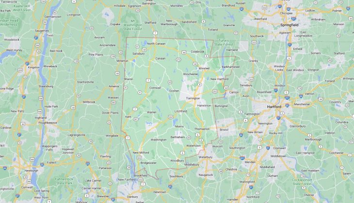
Cities and Towns in Litchfield County, Connecticut
Founded in 1751, Litchfield County is one of 8 counties in the state of Connecticut. Historically, Litchfield County was formed from parts of Fairfield, Hartford and New Haven Counties. The city of N/A; historically Litchfield is the county seat. With FIPS code of 5, Litchfield County has a population of 185,000 and area of 920 square miles (2,383 km²).
List of all cities in Litchfield County, CT alphabetically
City/Town | Postal Code | Area Code |
Bakersville, CT | 06057 | 860/959 |
Bantam, CT | 06750 | 860/959 |
Barkhamsted, CT | 06063 | 860/959 |
Bethlehem, CT | 06751 | 203/475 |
Bridgewater, CT | 06752 | 860/959 |
Canaan, CT | 06018 | 860/959 |
06031 | 860/959 | |
Colbrook, CT | 06021 | 860/959 |
Colebrook, CT | 06021 | 860/959 |
Cornwall, CT | 06753 | 860/959 |
06796 | 860/959 | |
Cornwall Bridge, CT | 06754 | 860/959 |
East Canaan, CT | 06024 | 860/959 |
Falls Village, CT | 06031 | 860/959 |
Gaylordsville, CT | 06755 | 860/959 |
Goshen, CT | 06756 | 860/959 |
Harwinton, CT | 06791 | 860/959 |
Harwinton, CT | 06792 | 860/959 |
Hotchkiss School, CT | 06039 | 860/959 |
Kent, CT | 06757 | 860/959 |
Lakeside, CT | 06758 | 860/959 |
Lakeville, CT | 06039 | 860/959 |
Litchfield, CT | 06750 | 860/959 |
06759 | 860/959 | |
06778 | 860/959 | |
M B I Inc, CT | 06792 | 860/959 |
Marble Dale, CT | 06777 | 860/959 |
Morris, CT | 06758 | 860/959 |
06763 | 860/959 | |
Nepaug, CT | 06057 | 860/959 |
New Hartford, CT | 06057 | 860/959 |
New Milford, CT | 06776 | 860/959 |
New Preston, CT | 06777 | 860/959 |
New Preston Marble Dale, CT | 06777 | 860/959 |
No Canaan, CT | 06018 | 860/959 |
Norfolk, CT | 06058 | 860/959 |
North Canaan, CT | 06018 | 860/959 |
Northfield, CT | 06778 | 860/959 |
06787 | 860/959 | |
Northville, CT | 06776 | 860/959 |
Oakville, CT | 06779 | 860/959 |
Oakville, CT | 06795 | 860/959 |
Pequabuck, CT | 06781 | 860/959 |
Pine Meadow, CT | 06061 | 860/959 |
Pleasant Valley, CT | 06063 | 860/959 |
Plymouth, CT | 06782 | 860/959 |
Riverton, CT | 06065 | 860/959 |
Roxbury, CT | 06783 | 203/475 |
Salisbury, CT | 06068 | 860/959 |
06079 | 860/959 | |
Sharon, CT | 06069 | 860/959 |
Sharon Valley, CT | 06069 | 860/959 |
South Canaan, CT | 06031 | 860/959 |
South Kent, CT | 06785 | 860/959 |
Taconic, CT | 06079 | 860/959 |
Terryville, CT | 06786 | 860/959 |
Thomaston, CT | 06778 | 860/959 |
06787 | 860/959 | |
Torrington, CT | 06790 | 860/959 |
06791 | 860/959 | |
Torrington, CT | 06792 | 860/959 |
Twin Lakes, CT | 06079 | 860/959 |
Warren, CT | 06754 | 860/959 |
06777 | 860/959 | |
Washington, CT | 06777 | 860/959 |
06793 | 860/959 | |
06794 | 860/959 | |
Washington Depot, CT | 06777 | 860/959 |
06793 | 860/959 | |
06794 | 860/959 | |
Washington Green, CT | 06793 | 860/959 |
Watertown, CT | 06779 | 860/959 |
06795 | 860/959 | |
West Cornwall, CT | 06796 | 860/959 |
West Woods, CT | 06069 | 860/959 |
Winchester, CT | 06094 | 860/959 |
06098 | 860/959 | |
Winchester Center, CT | 06094 | 860/959 |
06098 | 860/959 | |
Winsted, CT | 06063 | 860/959 |
06094 | 860/959 | |
06098 | 860/959 | |
Woodbury, CT | 06798 | 203/475 |
Major Cities and Towns in Litchfield County, Connecticut
Torrington
Area, Population, Zip Codes, and Coordinates
- Area: 40.4 square miles
- Population: Approximately 34,442 (2020 Census)
- Zip Codes: 06790
- Latitude and Longitude: 41.8004° N, 73.1212° W
Location and History
Torrington is the largest city in Litchfield County, located in the northwestern part of Connecticut. The area was originally settled in the early 18th century and became an official town in 1740. Torrington’s location along the Naugatuck River made it a prime site for industrial development in the 19th century, particularly in the production of brass, needles, and textiles. The city’s industrial boom attracted a diverse population, contributing to its growth and development. Despite its industrial roots, Torrington has maintained much of its natural beauty, with rolling hills and scenic views surrounding the city. In recent years, Torrington has focused on revitalizing its downtown area, promoting arts, culture, and community events.
Major Schools and Landmarks
Torrington is served by the Torrington Public Schools district, with Torrington High School being the primary educational institution. The city is also home to the Northwestern Connecticut Community College, offering a range of academic programs and contributing to the local educational landscape. Major landmarks in Torrington include the Warner Theatre, a historic 1930s art deco theater that hosts performances, movies, and events, and the Torrington Historical Society, which preserves the city’s rich history through exhibits and educational programs. The nearby Burr Pond State Park offers residents and visitors opportunities for swimming, fishing, and hiking, making it a popular spot for outdoor recreation.
Litchfield
Area, Population, Zip Codes, and Coordinates
- Area: 56.8 square miles
- Population: Approximately 8,192 (2020 Census)
- Zip Codes: 06759
- Latitude and Longitude: 41.7476° N, 73.1887° W
Location and History
Litchfield is a historic town located in the heart of Litchfield County. Established in 1719, Litchfield quickly became an important center for law, education, and culture in Connecticut. The town was the site of the Litchfield Law School, the first law school in the United States, founded by Tapping Reeve in 1784. Litchfield’s well-preserved colonial architecture and charming village green make it one of the most picturesque towns in New England. The town played a significant role during the American Revolution, serving as a supply depot and home to notable figures such as Ethan Allen. Today, Litchfield is known for its rich history, scenic beauty, and vibrant cultural scene.
Major Schools and Landmarks
Litchfield is served by the Litchfield Public Schools district, with Litchfield High School being the primary educational institution. The town is also home to several private schools, including the Forman School, which offers specialized education for students with learning differences. Major landmarks in Litchfield include the Tapping Reeve House and Law School, a museum dedicated to the history of legal education in America, and the Litchfield Historical Society, which operates several historic sites and offers programs on the town’s history. The White Memorial Conservation Center, a 4,000-acre nature preserve, provides opportunities for hiking, birdwatching, and environmental education, making it a popular destination for nature enthusiasts.
New Milford
Area, Population, Zip Codes, and Coordinates
- Area: 63.7 square miles
- Population: Approximately 28,115 (2020 Census)
- Zip Codes: 06776
- Latitude and Longitude: 41.5805° N, 73.4101° W
Location and History
New Milford is the largest town in Litchfield County by area, located in the southwestern part of the county along the Housatonic River. The town was settled in 1707 and officially incorporated in 1712. New Milford’s early economy was based on agriculture, with dairy farming and tobacco being prominent industries. The town’s location along the river also made it an important center for trade and transportation. In the 19th century, New Milford experienced industrial growth, particularly in the production of hats and paper. Today, New Milford is a vibrant community known for its historic downtown, scenic landscapes, and strong sense of community. The town offers a mix of suburban amenities and rural charm, making it a desirable place to live.
Major Schools and Landmarks
New Milford is served by the New Milford School District, with New Milford High School being the primary educational institution. The town is also home to Canterbury School, a private college preparatory school known for its rigorous academic programs. Major landmarks in New Milford include the New Milford Historical Society and Museum, which offers exhibits on the town’s history, and the Lover’s Leap State Park, featuring scenic views of the Housatonic River and a historic iron bridge. The town’s annual Village Fair Days, held on the town green, is a popular event that celebrates New Milford’s community spirit with food, crafts, and entertainment.
Torrington
Area, Population, Zip Codes, and Coordinates
- Area: 40.4 square miles
- Population: Approximately 34,442 (2020 Census)
- Zip Codes: 06790
- Latitude and Longitude: 41.8004° N, 73.1212° W
Location and History
Torrington is the largest city in Litchfield County, located in the northwestern part of Connecticut. The area was originally settled in the early 18th century and became an official town in 1740. Torrington’s location along the Naugatuck River made it a prime site for industrial development in the 19th century, particularly in the production of brass, needles, and textiles. The city’s industrial boom attracted a diverse population, contributing to its growth and development. Despite its industrial roots, Torrington has maintained much of its natural beauty, with rolling hills and scenic views surrounding the city. In recent years, Torrington has focused on revitalizing its downtown area, promoting arts, culture, and community events.
Major Schools and Landmarks
Torrington is served by the Torrington Public Schools district, with Torrington High School being the primary educational institution. The city is also home to the Northwestern Connecticut Community College, offering a range of academic programs and contributing to the local educational landscape. Major landmarks in Torrington include the Warner Theatre, a historic 1930s art deco theater that hosts performances, movies, and events, and the Torrington Historical Society, which preserves the city’s rich history through exhibits and educational programs. The nearby Burr Pond State Park offers residents and visitors opportunities for swimming, fishing, and hiking, making it a popular spot for outdoor recreation.
Watertown
Area, Population, Zip Codes, and Coordinates
- Area: 29.6 square miles
- Population: Approximately 22,105 (2020 Census)
- Zip Codes: 06795
- Latitude and Longitude: 41.6065° N, 73.1179° W
Location and History
Watertown is a charming town located in the southeastern part of Litchfield County, near the Naugatuck River. The town was first settled in 1701 and incorporated in 1780, originally known for its agricultural economy. Watertown’s growth was significantly influenced by the industrial revolution, particularly with the establishment of the Heminway & Bartlett Silk Company in the 19th century, which made the town a center for silk production. The town’s historic district features well-preserved homes and buildings from this period, reflecting its industrial heritage. Today, Watertown is a blend of suburban and rural living, offering residents a peaceful environment with easy access to larger cities.
Major Schools and Landmarks
Watertown is served by the Watertown School District, with Watertown High School and Swift Middle School being the main educational institutions. The town is also home to the Taft School, a prestigious private boarding school known for its academic excellence and historic campus. Major landmarks in Watertown include the Watertown Historical Society Museum, which showcases the town’s history and industrial heritage, and Black Rock State Park, offering hiking, fishing, and camping opportunities in a scenic natural setting. The town’s annual Fall Festival is a popular event that brings the community together to celebrate local culture with crafts, food, and entertainment.
Winchester
Area, Population, Zip Codes, and Coordinates
- Area: 33.8 square miles
- Population: Approximately 10,224 (2020 Census)
- Zip Codes: 06098
- Latitude and Longitude: 41.9259° N, 73.1045° W
Location and History
Winchester is a small town located in the northern part of Litchfield County, known for its historic charm and natural beauty. The town was incorporated in 1771 and developed as an agricultural community, with farming being the primary industry for much of its early history. In the 19th century, Winchester became known for its production of firearms, particularly with the establishment of the Winchester Repeating Arms Company, which played a significant role in the town’s economy. The town is also home to the village of Winsted, which served as an important industrial center in the 19th and early 20th centuries. Today, Winchester offers a peaceful rural lifestyle with a rich historical backdrop.
Major Schools and Landmarks
Winchester is served by the Winchester School District, with Gilbert School being the primary educational institution, serving both as a middle and high school. The town is also home to Northwestern Connecticut Community College, providing higher education opportunities to residents. Major landmarks in Winchester include the Winchester Historical Society, which preserves the town’s history through exhibits and educational programs, and Highland Lake, a popular destination for boating, fishing, and swimming. The town’s historic district features well-preserved Victorian homes and buildings, reflecting its rich architectural heritage. The annual Winchester Grange Fair celebrates the town’s agricultural roots with events, contests, and community activities.