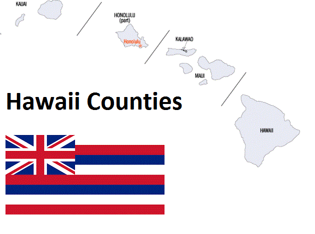
Hawaii Counties. List Alphabetically (and by Population)

How many counties are there in Hawaii? As of 2024, there are a total of 5 counties in the state of Hawaii.  With population of 953,207, Honolulu County is the most populated. The biggest county by land area is Hawaii County (10,432 km²) and the smallest is Kalawao County (13 km²).

Largest Counties in Hawaii

1. Hawaii County

County Seat: Hilo

  • Area: 4,028 square miles
  • Population: Approximately 200,629 (2020 census)
  • Area Codes: 808
  • Latitude: 19.7297° N
  • Longitude: 155.0900° W

Location and History

Hawaii County, often referred to as the “Big Island,” is the largest county in the state of Hawaii and encompasses the entire island of Hawaii. Established in 1905, the county’s history is rich with Hawaiian culture and traditions, as the island is considered the birthplace of King Kamehameha I, who unified the Hawaiian Islands. The county seat, Hilo, is the largest town on the island and has historically been a center for the sugar industry, though the economy has since diversified into tourism, agriculture, and astronomy. The Big Island is known for its diverse climates and ecosystems, from tropical rainforests to arid deserts, and is home to several active volcanoes, including Kilauea and Mauna Loa.

Major Highways and Landmarks

Hawaii County is served by major highways such as Hawaii Belt Road (Highways 11, 19, and 190), which circles the island, connecting Hilo, Kailua-Kona, and other communities. Key landmarks include Hawaii Volcanoes National Park, which encompasses two of the world’s most active volcanoes, and Mauna Kea, the highest point in the state, known for its world-class astronomical observatories. The island is also home to Akaka Falls, a stunning 442-foot waterfall, and the historic Pu’uhonua o Honaunau National Historical Park, a sacred site for ancient Hawaiian culture. The county’s varied landscapes, from black sand beaches to lush valleys like Waipio Valley, make it a premier destination for nature and adventure tourism.

2. Maui County

County Seat: Wailuku

  • Area: 2,398 square miles
  • Population: Approximately 164,754 (2020 census)
  • Area Codes: 808
  • Latitude: 20.8893° N
  • Longitude: 156.5061° W

Location and History

Maui County encompasses the islands of Maui, Molokai, Lanai, and the uninhabited Kahoolawe. Established in 1905, the county’s history is closely tied to the sugar and pineapple industries, though tourism has become the dominant economic force in recent decades. The county seat, Wailuku, is located on the island of Maui, which is known as the “Valley Isle” due to its scenic landscapes of valleys and mountains. Maui is also famous for its beaches, the Haleakala Volcano, and the historic whaling town of Lahaina. Molokai is known for its strong Native Hawaiian culture, while Lanai was once a major pineapple plantation and is now home to luxury resorts.

Major Highways and Landmarks

Maui County is accessible via several major highways, including the Hana Highway (Highway 36), which is renowned for its winding, scenic drive along Maui’s northeastern coast, and the Haleakala Highway (Highway 37), leading up to Haleakala National Park. Notable landmarks include Haleakala National Park, where visitors can watch the sunrise from the summit of the dormant volcano, and the historic Iao Valley, a lush, green valley with cultural significance. The county is also home to Molokini Crater, a popular snorkeling and diving site, and the remote, towering sea cliffs of Molokai’s Kalaupapa Peninsula, where a historic leprosy settlement was established in the 19th century. The Road to Hana is one of the most famous drives in the world, leading through rainforests, waterfalls, and coastal vistas.

3. Honolulu County

County Seat: Honolulu

  • Area: 2,128 square miles
  • Population: Approximately 1,016,508 (2020 census)
  • Area Codes: 808
  • Latitude: 21.3069° N
  • Longitude: 157.8583° W

Location and History

Honolulu County, also known as the City and County of Honolulu, encompasses the entire island of Oahu, including the state capital, Honolulu. Established in 1907, it is the most populous county in Hawaii and serves as the economic and cultural center of the state. The city of Honolulu has a rich history, including its role as the former seat of the Hawaiian monarchy and its significance in World War II, particularly the attack on Pearl Harbor. The county’s economy is driven by tourism, military defense, and business services, with Waikiki Beach being one of the most famous tourist destinations in the world.

Major Highways and Landmarks

Honolulu County is served by several major highways, including Interstate H-1, which runs through the southern part of Oahu, connecting Honolulu with Pearl Harbor and other key areas, and Interstate H-3, which provides a direct route from Pearl Harbor to Kaneohe. Key landmarks include Pearl Harbor, home to the USS Arizona Memorial and other significant World War II sites, and Diamond Head, a volcanic tuff cone and iconic symbol of Hawaii. Waikiki Beach is another major attraction, known for its golden sands, high-end hotels, and vibrant nightlife. The county also boasts the historic Iolani Palace, the only royal palace on U.S. soil, and the Bishop Museum, which houses extensive collections related to Hawaiian and Pacific Island cultures.

4. Kauai County

County Seat: Lihue

  • Area: 1,266 square miles
  • Population: Approximately 73,298 (2020 census)
  • Area Codes: 808
  • Latitude: 21.9713° N
  • Longitude: 159.3670° W

Location and History

Kauai County includes the islands of Kauai, Niihau, Lehua, and Kaula. Kauai, known as the “Garden Isle” due to its lush landscapes, is the oldest of the main Hawaiian Islands. The county was established in 1905, and Lihue, the county seat, developed as a center for sugar production in the 19th century. Today, Kauai’s economy is primarily driven by tourism, with visitors attracted to the island’s natural beauty, outdoor activities, and laid-back atmosphere. Niihau, a privately-owned island, is known for its Native Hawaiian population and traditional way of life, largely isolated from modern influence.

Major Highways and Landmarks

Kauai County is accessible via major highways such as Kuhio Highway (Highway 56), which runs along the eastern and northern coasts of Kauai, and Kaumualii Highway (Highway 50), which extends westward from Lihue. Key landmarks include the Na Pali Coast, famous for its dramatic cliffs and remote hiking trails, and Waimea Canyon, often referred to as the “Grand Canyon of the Pacific” for its deep valleys and stunning colors. The county is also home to Hanalei Bay, a picturesque crescent-shaped bay on the north shore, and the Wailua River, where visitors can explore ancient Hawaiian sites and waterfalls. The island’s botanical gardens, such as Allerton Garden and McBryde Garden, showcase the island’s diverse plant life.

5. Kalawao County

County Seat: Kalaupapa

  • Area: 53 square miles
  • Population: Approximately 82 (2020 census)
  • Area Codes: 808
  • Latitude: 21.1869° N
  • Longitude: 156.9829° W

Location and History

Kalawao County is located on the island of Molokai and is the smallest county in Hawaii by both area and population. Established in 1905, the county is unique in that it was specifically created to house individuals with Hansen’s disease (leprosy) at the Kalaupapa settlement. The settlement was established in the 19th century as a quarantine area for those afflicted with the disease, which was highly stigmatized at the time. Father Damien, a Belgian priest who cared for patients at Kalaupapa, was later canonized as a saint for his work. The county remains a historical site, managed by the National Park Service, and is accessible only by mule ride, hiking, or airplane.

Major Highways and Landmarks

Kalawao County is isolated, with no major highways leading to it directly. Access is primarily through Kalaupapa’s small airport or by a steep mule trail down the cliffs of Molokai. The primary landmark is the Kalaupapa National Historical Park, which preserves the history of the Hansen’s disease settlement and the stories of those who lived there. The park includes Father Damien’s church and grave, as well as the homes and facilities used by the residents. The county’s remote location and dramatic landscapes offer a unique glimpse into a poignant chapter of Hawaii’s history. Visiting Kalawao County requires a permit, and the site is highly regulated to preserve its historical and cultural significance.

List of All Counties in Hawaii Alphabetically

Below please see all Hawaii counties which are listed in alphabetical order.

  1. Hawaii County, HI
  2. Honolulu County, HI
  3. Kalawao County, HI
  4. Kauai County, HI
  5. Maui County, HI

Map of Hawaii Counties

Map of Hawaii Counties