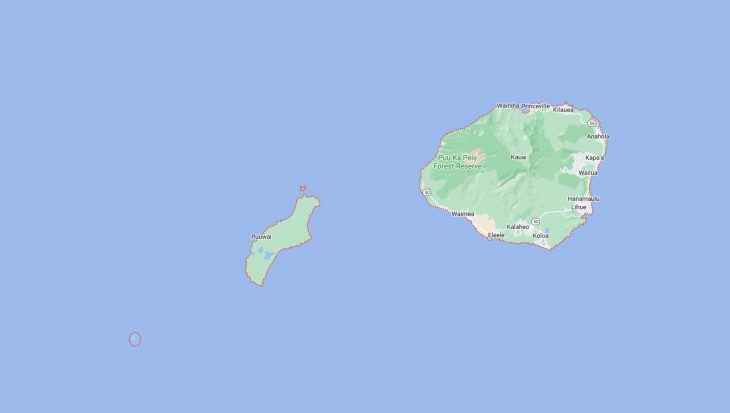
Cities and Towns in Kauai County, Hawaii

Founded in 1905, Kauai County is one of 5 counties in the state of Hawaii. Historically, Kauai County was formed from Kauai, Niʻihau, Lehua, and Kaʻula. The city of Lihue is the county seat. With FIPS code of 7, Kauai County has a population of 73,454 and area of 622 square miles (1,611 km²).

List of all cities in Kauai County, HI alphabetically

City/Town Postal Code Area Code
Anahola, HI 96703 808
Eleele, HI 96705 808
Hanalei, HI 96714 808
Hanamaulu, HI 96715 808
Hanapepe, HI 96716 808
Kalaheo, HI 96741 808
Kapaa, HI 96746 808
Kaumakani, HI 96747 808
Kealia, HI 96751 808
Kekaha, HI 96752 808
Kilauea, HI 96722 808
96754 808
Koloa, HI 96756 808
Lawai, HI 96765 808
Lihue, HI 96766 808
Makaweli, HI 96769 808
Princeville, HI 96714 808
96722 808
Waimea, HI 96796 808

Major Cities and Towns in Kauai County, Hawaii

Lihue

Area, Population, Zip Codes, Latitude, and Longitude

  • Area: 7.1 square miles
  • Population: 8,004 (as of the 2020 census)
  • Zip Codes: 96766
  • Latitude: 21.9811° N
  • Longitude: 159.3673° W

Location and History

Lihue is the county seat and largest town in Kauai County, located on the southeastern coast of the island of Kauai. The town was established in the mid-19th century and quickly became a center of commerce and government for the island. Lihue’s growth was closely tied to the sugar industry, with the Lihue Plantation being one of the most significant employers on the island for many years. Today, Lihue remains the administrative and commercial heart of Kauai, with the island’s main airport and seaport located here. The town is known for its historical landmarks, such as the Kilohana Plantation, which offers a glimpse into the island’s agricultural past. Despite its small size, Lihue plays a crucial role in the daily life of Kauai, serving as a hub for transportation, business, and government.

Major Schools and Landmarks

Lihue is served by the Hawaii Department of Education, with major schools including Kauai High School and Chiefess Kamakahelei Middle School. The town is home to several significant landmarks, including the Kauai Museum, which offers exhibits on the island’s history, culture, and natural environment. The historic Kilohana Plantation, once a thriving sugar plantation, is now a popular tourist destination, offering tours, a railway ride, and a restaurant. Another key site is the Wailua Falls, located just outside Lihue, which is one of the island’s most famous waterfalls. The town’s proximity to Nawiliwili Harbor, the main port for cruise ships and cargo, and the Lihue Airport, which connects Kauai to the rest of Hawaii and the mainland, makes Lihue a critical gateway to the island. Lihue’s central location also provides easy access to the island’s many natural attractions, including the Wailua River and the beaches of the eastern shore.

Kapaa

Area, Population, Zip Codes, Latitude, and Longitude

  • Area: 10.2 square miles
  • Population: 11,652 (as of the 2020 census)
  • Zip Codes: 96746
  • Latitude: 22.0881° N
  • Longitude: 159.3379° W

Location and History

Kapaa is a charming town located on the eastern coast of Kauai, just north of Lihue. The town was originally developed as a plantation town in the late 19th century, with the sugar and pineapple industries playing central roles in its economy. Over time, Kapaa has transformed into a popular destination for both locals and tourists, known for its beautiful beaches, vibrant shopping districts, and outdoor recreational opportunities. The town’s location along the Coconut Coast, named for the coconut groves that line its shores, makes it a scenic and desirable place to live and visit. Kapaa’s blend of historical charm and modern amenities has made it one of the most visited towns on the island.

Major Schools and Landmarks

Kapaa is part of the Hawaii Department of Education, with major schools including Kapaa High School and Kapaa Elementary School. The town is home to several notable landmarks, including the Kauai Path, a coastal bike and walking path that offers stunning views of the ocean and access to several beaches. The historic Kapaa Town, with its plantation-era buildings, is now a bustling area filled with shops, restaurants, and art galleries. Another key site is the Hindu Monastery, located just outside Kapaa, which is a place of worship and meditation set in lush tropical surroundings. The nearby Nounou Mountain, also known as the Sleeping Giant, offers popular hiking trails with panoramic views of the island. Kapaa’s annual events, such as the Coconut Festival, celebrate the town’s cultural heritage and attract visitors from across the island and beyond.

Hanalei

Area, Population, Zip Codes, Latitude, and Longitude

  • Area: 0.8 square miles
  • Population: 450 (as of the 2020 census)
  • Zip Codes: 96714
  • Latitude: 22.2030° N
  • Longitude: 159.4975° W

Location and History

Hanalei is a picturesque town located on the northern shore of Kauai, nestled in a stunning valley surrounded by lush mountains and taro fields. The town is known for its natural beauty, with Hanalei Bay being one of the most famous and photographed beaches in Hawaii. Hanalei’s history dates back to ancient Hawaiian times, when it was an important agricultural center, particularly for taro cultivation, which continues to this day. The town played a significant role in Hawaiian culture and history, and its historic sites, such as the Waioli Huiia Church, reflect its rich heritage. Hanalei has maintained its small-town charm and traditional Hawaiian character, making it a popular destination for those seeking a more authentic and tranquil experience of the island.

Major Schools and Landmarks

Hanalei is served by the Hawaii Department of Education, with students typically attending Hanalei Elementary School and continuing their education in nearby towns such as Kapaa. The town is home to several significant landmarks, including the Hanalei Pier, a popular spot for fishing and photography, and the historic Waioli Huiia Church, which was built in 1912 and is a testament to the town’s missionary past. Hanalei Bay, with its wide crescent of white sand and calm waters, is a favorite spot for swimming, surfing, and stand-up paddleboarding. The surrounding Hanalei Valley is one of the most important taro-growing regions in Hawaii, and visitors can see the patchwork of taro fields from the Hanalei Valley Lookout. The town’s annual Hanalei Bay Swim Challenge is a popular event that draws participants from all over the world. Hanalei’s combination of natural beauty, history, and laid-back atmosphere makes it a unique and beloved part of Kauai.

Princeville

Area, Population, Zip Codes, Latitude, and Longitude

  • Area: 2.5 square miles
  • Population: 2,158 (as of the 2020 census)
  • Zip Codes: 96722
  • Latitude: 22.2233° N
  • Longitude: 159.4850° W

Location and History

Princeville is a master-planned community located on the northern shore of Kauai, near the town of Hanalei. The area was originally a large cattle ranch and was later named after Prince Albert Kamehameha, the son of King Kamehameha IV and Queen Emma. In the 1960s, Princeville was developed into a luxury resort community, with a focus on golf, recreation, and upscale living. Today, Princeville is known for its world-class resorts, golf courses, and stunning views of Hanalei Bay and the surrounding mountains. The community is a popular destination for visitors seeking a luxurious and serene Hawaiian experience, with easy access to the natural beauty of Kauai’s north shore.

Major Schools and Landmarks

Princeville is part of the Hawaii Department of Education, with students typically attending schools in nearby towns such as Hanalei and Kapaa. The community is home to several notable landmarks, including the Princeville Makai Golf Club, which is consistently ranked among the top golf courses in Hawaii and offers breathtaking views of the Pacific Ocean. Another key site is the Princeville Botanical Gardens, where visitors can explore a diverse array of tropical plants, flowers, and fruits. The nearby Queen’s Bath, a natural tide pool formed in a lava shelf, is a popular yet often dangerous spot for swimming during calm seas. The Princeville Resort, now the 1 Hotel Hanalei Bay, is a luxury hotel that offers visitors world-class amenities and stunning views of the bay and mountains. Princeville’s blend of luxury living, natural beauty, and proximity to some of Kauai’s most famous attractions makes it a premier destination on the island.

Waimea

Area, Population, Zip Codes, Latitude, and Longitude

  • Area: 1.3 square miles
  • Population: 2,057 (as of the 2020 census)
  • Zip Codes: 96796
  • Latitude: 21.9597° N
  • Longitude: 159.6681° W

Location and History

Waimea is a historic town located on the southwestern coast of Kauai, known for its rich history and as the gateway to Waimea Canyon, often referred to as the “Grand Canyon of the Pacific.” The town’s history dates back to the time of Captain James Cook, who made his first landing in Hawaii at Waimea Bay in 1778, marking the first recorded contact between Europeans and Hawaiians. Waimea later became an important center for the sugar industry, with plantations and a bustling port that shipped sugar to the mainland. The town’s historical significance is evident in its well-preserved buildings and cultural landmarks, making it a key location for understanding Kauai’s past.

Major Schools and Landmarks

Waimea is part of the Hawaii Department of Education, with major schools including Waimea High School and Waimea Canyon Middle School. The town is home to several significant landmarks, including the Captain Cook Monument, which commemorates Cook’s first landing in Hawaii. The Russian Fort Elizabeth State Historical Park, located near the mouth of the Waimea River, offers a glimpse into the island’s colonial history, with the remains of a fort built by the Russian-American Company in 1817. Another key site is the nearby Waimea Canyon, a massive geological formation that stretches for 14 miles and offers stunning views, hiking trails, and waterfalls. The town’s annual Waimea Town Celebration is one of the oldest festivals on the island, celebrating Waimea’s rich history and community spirit with parades, cultural events, and local food. Waimea’s combination of historical significance, natural beauty, and vibrant community life makes it a unique and important part of Kauai.

Map of Cities in Kauai County, HI

Map of Cities in Kauai County, HI