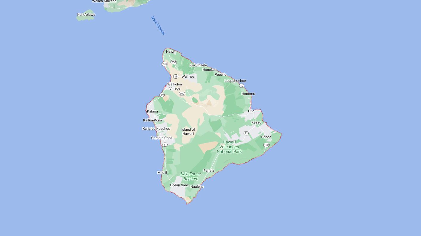
Cities and Towns in Hawaii County, Hawaii
Founded in 1905, Hawaii County is one of 5 counties in the state of Hawaii. Historically, Hawaii County was formed from Hawaiʻi. The city of Hilo is the county seat. With FIPS code of 1, Hawaii County has a population of 202,906 and area of 4,028 square miles (10,432 km²).
List of all cities in Hawaii County, HI alphabetically
| City/Town | Postal Code | Area Code |
| Ahualoa, HI | 96727 | 808 |
| Captain Cook, HI | 96704 | 808 |
| Hakalau, HI | 96710 | 808 |
| Hawaii National Park, HI | 96718 | 808 |
| Hawi, HI | 96719 | 808 |
| Hi National Park, HI | 96718 | 808 |
| Hilo, HI | 96720 | 808 |
| Hilo, HI | 96721 | 808 |
| Holualoa, HI | 96725 | 808 |
| Honaunau, HI | 96726 | 808 |
| Honokaa, HI | 96727 | 808 |
| Honomu, HI | 96728 | 808 |
| Kailua Kona, HI | 96739 | 808 |
| 96740 | 808 | |
| 96745 | 808 | |
| Kamuela, HI | 96743 | 808 |
| Kapaau, HI | 96755 | 808 |
| Kawaihae, HI | 96743 | 808 |
| Keaau, HI | 96749 | 808 |
| Kealakekua, HI | 96750 | 808 |
| Keauhou, HI | 96739 | 808 |
| Kukuihaele, HI | 96727 | 808 |
| Kurtistown, HI | 96760 | 808 |
| Laupahoehoe, HI | 96764 | 808 |
| Mountain View, HI | 96771 | 808 |
| Naalehu, HI | 96772 | 808 |
| Ninole, HI | 96773 | 808 |
| Ocean View, HI | 96737 | 808 |
| Ookala, HI | 96774 | 808 |
| Paauhau, HI | 96727 | 808 |
| Paauilo, HI | 96776 | 808 |
| Pahala, HI | 96777 | 808 |
| Pahoa, HI | 96778 | 808 |
| Papaaloa, HI | 96780 | 808 |
| Papaikou, HI | 96781 | 808 |
| Pepeekeo, HI | 96783 | 808 |
| Volcano, HI | 96785 | 808 |
| Waikoloa, HI | 96738 | 808 |
Major Cities and Towns in Hawaii County, Hawaii
Hilo
Area, Population, Zip Codes, Latitude, and Longitude
- Area: 58.3 square miles
- Population: 44,186 (as of the 2020 census)
- Zip Codes: 96720, 96721
- Latitude: 19.7071° N
- Longitude: 155.0816° W
Location and History
Hilo is the largest city and the county seat of Hawaii County, located on the eastern side of the Big Island of Hawaii. The city has a rich history, dating back to ancient Hawaiian times when it was an important agricultural and fishing area. In the 19th century, Hilo became a hub for the sugarcane industry, which drove much of the economic growth in the region. The city’s location near two shield volcanoes, Mauna Loa and Mauna Kea, makes it a unique and picturesque setting, though it has also made Hilo vulnerable to natural disasters such as tsunamis. Despite these challenges, Hilo has thrived as a center of culture, education, and government on the island. The city is known for its lush rainforests, beautiful gardens, and as the gateway to Hawaii Volcanoes National Park.
Major Schools and Landmarks
Hilo is served by the Hawaii Department of Education, with major schools including Hilo High School and Waiakea High School. The University of Hawaii at Hilo is a key institution in the city, offering a range of undergraduate and graduate programs and contributing to the city’s cultural and intellectual life. Hilo is home to several notable landmarks, including the Liliuokalani Gardens, a beautifully landscaped Japanese garden that reflects the town’s multicultural heritage. Another significant site is the Pacific Tsunami Museum, which educates visitors about the devastating tsunamis that have impacted Hilo. The nearby Rainbow Falls is a popular tourist attraction, known for the beautiful rainbow that often appears in the mist. Hilo’s historic downtown area, with its well-preserved buildings and shops, offers a glimpse into the city’s past and remains a vibrant center for commerce and community events. The annual Merrie Monarch Festival, a world-renowned hula competition, draws visitors from around the globe and celebrates Hawaiian culture and traditions.
Kailua-Kona
Area, Population, Zip Codes, Latitude, and Longitude
- Area: 39.3 square miles
- Population: 21,874 (as of the 2020 census)
- Zip Codes: 96740, 96745
- Latitude: 19.6399° N
- Longitude: 155.9969° W
Location and History
Kailua-Kona, often simply referred to as Kona, is a historic town located on the western coast of the Big Island of Hawaii. The area has a rich history as a former residence of Hawaiian royalty, including King Kamehameha I, who established Kona as the capital of the Kingdom of Hawaii in the early 19th century. The town’s location on the leeward side of the island gives it a drier climate than Hilo, making it ideal for growing coffee, and Kona coffee has become one of the most famous and sought-after coffees in the world. Today, Kailua-Kona is a bustling town known for its tourism, with beautiful beaches, resorts, and a lively waterfront that attracts visitors year-round.
Major Schools and Landmarks
Kailua-Kona is part of the Hawaii Department of Education, with major schools including Kealakehe High School and Konawaena High School. The town is home to several significant landmarks, including the Hulihee Palace, a former royal residence that is now a museum showcasing Hawaiian artifacts and the lifestyle of the Hawaiian monarchy. The Mokuaikaua Church, built in 1820, is the oldest Christian church in Hawaii and stands as a testament to the influence of missionaries on the island. Another key site is the Kailua Pier, which serves as the starting and finishing point for the Ironman World Championship triathlon, one of the most prestigious endurance events in the world. Kona’s beaches, such as Magic Sands Beach and Kahalu’u Beach Park, are popular spots for snorkeling, swimming, and surfing. The town’s annual Kona Coffee Cultural Festival celebrates the rich history and culture of coffee farming in the region, highlighting the importance of Kona coffee to the local economy.
Waimea (Kamuela)
Area, Population, Zip Codes, Latitude, and Longitude
- Area: 39.8 square miles
- Population: 7,028 (as of the 2020 census)
- Zip Codes: 96743
- Latitude: 20.0244° N
- Longitude: 155.6708° W
Location and History
Waimea, also known as Kamuela, is a town located in the northern part of the Big Island of Hawaii, in the lush, green uplands of the island. The area has a rich history as the center of cattle ranching in Hawaii, with Parker Ranch, one of the largest privately owned cattle ranches in the United States, playing a significant role in the town’s development. Waimea’s unique location at a higher elevation gives it a cooler climate than much of the island, making it ideal for ranching and agriculture. The town has a strong paniolo (Hawaiian cowboy) culture, and this heritage is celebrated in various events and landmarks throughout the town.
Major Schools and Landmarks
Waimea is served by the Hawaii Department of Education, with major schools including Hawaii Preparatory Academy and Parker School, both of which are private schools with strong academic reputations. The town is home to several significant landmarks, including the Parker Ranch, where visitors can learn about the history of cattle ranching in Hawaii and explore the historic homes of the ranch’s founders. Another key site is the Anna Ranch Heritage Center, which offers a glimpse into the life of one of Hawaii’s most prominent ranching families. The town’s annual Waimea Cherry Blossom Heritage Festival celebrates the town’s Japanese heritage and the beautiful cherry trees that bloom in the area. Waimea’s proximity to Mauna Kea makes it a gateway for visitors heading to the Mauna Kea Observatories, one of the world’s premier astronomical research facilities. The town’s rural charm, combined with its rich cultural heritage, makes Waimea a unique and important community on the Big Island.
Pahoa
Area, Population, Zip Codes, Latitude, and Longitude
- Area: 2.3 square miles
- Population: 924 (as of the 2020 census)
- Zip Codes: 96778
- Latitude: 19.4954° N
- Longitude: 154.9457° W
Location and History
Pahoa is a small town located in the Puna District on the eastern side of the Big Island of Hawaii. The town has a history that dates back to the early 20th century, when it developed as a center for the sugarcane and lumber industries. Pahoa’s history is marked by its resilience in the face of natural disasters, particularly the volcanic activity from Kilauea, which has impacted the area multiple times. Despite these challenges, Pahoa has maintained its unique character and has become known for its eclectic, bohemian atmosphere, attracting artists, musicians, and those seeking a more alternative lifestyle. The town’s rustic charm and proximity to Hawaii Volcanoes National Park make it a popular destination for visitors looking to explore the more off-the-beaten-path areas of the island.
Major Schools and Landmarks
Pahoa is part of the Hawaii Department of Education, with major schools including Pahoa High and Intermediate School. The town is home to several significant landmarks, including the historic Pahoa Village, which features a mix of wooden boardwalks, old-style buildings, and local shops that reflect the town’s laid-back, artistic vibe. The nearby Lava Tree State Monument is a unique natural attraction, where visitors can see lava molds of trees that were encased by a lava flow in the 18th century. The town is also close to the Puna Geothermal Venture, a geothermal power plant that harnesses the heat from the Kilauea volcano to generate electricity. Pahoa’s location near the active volcano makes it a key area for understanding the dynamic geology of the island. The town’s annual Pahoa Holiday Parade is a community event that brings together residents and visitors to celebrate the town’s unique culture and spirit.
Hawi
Area, Population, Zip Codes, Latitude, and Longitude
- Area: 2.5 square miles
- Population: 1,081 (as of the 2020 census)
- Zip Codes: 96719
- Latitude: 20.2417° N
- Longitude: 155.8333° W
Location and History
Hawi is a small, charming town located in the northernmost part of the Big Island of Hawaii, in the North Kohala District. The town has a rich history, particularly in relation to King Kamehameha I, who was born nearby and later unified the Hawaiian Islands. In the late 19th and early 20th centuries, Hawi became a bustling center for the sugar industry, with the Kohala Sugar Plantation driving much of the local economy. After the decline of sugarcane production in the mid-20th century, Hawi transformed into a quiet, rural community with a focus on tourism, arts, and agriculture. Today, the town is known for its vibrant arts scene, historic buildings, and beautiful coastal views.
Major Schools and Landmarks
Hawi is served by the Hawaii Department of Education, with students typically attending schools in nearby towns such as Kapaau. The town is home to several significant landmarks, including the King Kamehameha Statue, which honors the legacy of Hawaii’s first king and is located in nearby Kapaau. Another key site is the Kohala Historical Sites State Monument, which includes the Mo’okini Heiau, an ancient Hawaiian temple that dates back over 1,500 years and is one of the oldest historical sites in Hawaii. The Pololu Valley Lookout, located a short drive from Hawi, offers stunning views of the rugged Kohala coastline and access to a trail that leads down to the black sand beach in the valley. Hawi’s vibrant art galleries, boutique shops, and local eateries reflect the town’s creative spirit and commitment to preserving its unique cultural heritage. The town’s annual Kohala Country Fair is a popular event that celebrates the community’s agricultural roots and brings together residents and visitors for a day of food, music, and family-friendly activities.
Volcano
Area, Population, Zip Codes, Latitude, and Longitude
- Area: 58.5 square miles
- Population: 3,570 (as of the 2020 census)
- Zip Codes: 96785
- Latitude: 19.4258° N
- Longitude: 155.2350° W
Location and History
Volcano is a small town located in the Puna District on the Big Island of Hawaii, near the entrance to Hawaii Volcanoes National Park. The town’s history is closely tied to the volcanic activity of Kilauea, one of the most active volcanoes in the world. The area has been inhabited for centuries, with ancient Hawaiians living in the region long before the arrival of Western explorers. In the late 19th and early 20th centuries, Volcano began to develop as a community, with settlers drawn to the area by its cool climate and fertile soil. The town’s proximity to Kilauea has made it a popular destination for scientists, artists, and tourists alike, who come to witness the dramatic volcanic landscapes and experience the unique environment.
Major Schools and Landmarks
Volcano is part of the Hawaii Department of Education, with students typically attending schools in nearby towns such as Keaau and Pahoa. The town is home to several significant landmarks, most notably Hawaii Volcanoes National Park, which is a UNESCO World Heritage Site and one of the most popular tourist attractions in Hawaii. The park offers visitors the chance to explore the diverse volcanic landscapes, including active lava flows, craters, and lava tubes. The Thomas A. Jaggar Museum, located within the park, provides educational exhibits on volcanology and the history of volcanic activity in Hawaii. The nearby Volcano Art Center, housed in a historic building, serves as a cultural hub for the community, offering art exhibitions, workshops, and performances that celebrate the natural beauty and cultural heritage of the area. Volcano’s annual events, such as the Volcano Village Art Studio Tour, highlight the town’s vibrant arts community and attract visitors from around the world. The town’s unique location and close connection to Hawaii’s volcanic history make it a fascinating place to live and visit.
Map of Cities in Hawaii County, HI