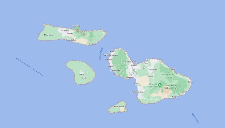
Cities and Towns in Maui County, Hawaii
Founded in 1905, Maui County is one of 5 counties in the state of Hawaii. Historically, Maui County was formed from Maui, Kahoʻolawe, Lānaʻi, Molokai (except the Kalaupapa Peninsula), and Molokini. The city of Wailuku is the county seat. With FIPS code of 9, Maui County has a population of 164,221 and area of 1,120 square miles (2,901 km²).
List of all cities in Maui County, HI alphabetically
City/Town | Postal Code | Area Code |
Haiku, HI | 96708 | 808 |
Hana, HI | 96713 | 808 |
Hana Maui, HI | 96713 | 808 |
Hoolehua, HI | 96729 | 808 |
Kahului, HI | 96732 | 808 |
96733 | 808 | |
Kalaupapa, HI | 96742 | 808 |
Kaunakakai, HI | 96748 | 808 |
Kihei, HI | 96753 | 808 |
Kualapuu, HI | 96757 | 808 |
Kula, HI | 96790 | 808 |
Lahaina, HI | 96761 | 808 |
96767 | 808 | |
Lanai City, HI | 96763 | 808 |
Makawao, HI | 96768 | 808 |
96788 | 808 | |
Maunaloa, HI | 96770 | 808 |
Paia, HI | 96779 | 808 |
Pukalani, HI | 96788 | 808 |
Pukalani Maui, HI | 96788 | 808 |
Puunene, HI | 96784 | 808 |
Wailea, HI | 96753 | 808 |
Wailuku, HI | 96793 | 808 |
Major Cities and Towns in Maui County, Hawaii
Kahului
Area, Population, Zip Codes, Latitude, and Longitude
- Area: 16.3 square miles
- Population: 26,337 (as of the 2020 census)
- Zip Codes: 96732, 96733
- Latitude: 20.8896° N
- Longitude: 156.4729° W
Location and History
Kahului is the largest town and the commercial hub of Maui County, located on the northern coast of the island of Maui. The town developed in the early 20th century as a center for the sugarcane industry, with the construction of the Kahului Railroad playing a significant role in its growth. Over time, Kahului evolved from an industrial town into a bustling commercial center, particularly with the development of Kahului Harbor, which remains a key transportation hub for the island. Today, Kahului is known for its shopping centers, including the Queen Ka‘ahumanu Center, and serves as the gateway to Maui for many visitors arriving at Kahului Airport, the island’s main airport. The town is also home to various government offices, educational institutions, and cultural sites, making it a central part of life on Maui.
Major Schools and Landmarks
Kahului is served by the Maui District of the Hawaii Department of Education, with major schools including Maui High School and Kahului Elementary School. The town is home to several notable landmarks, including the Maui Arts & Cultural Center, which hosts a variety of performances, exhibitions, and community events, making it a cultural hub for the island. The Alexander & Baldwin Sugar Museum, located nearby, provides insights into the history of the sugarcane industry that once dominated the region. Kanaha Beach Park, located on the town’s coastline, is a popular spot for windsurfing, kitesurfing, and other water sports, attracting both locals and tourists. The town’s central location makes it a convenient base for exploring the rest of Maui, including the scenic Road to Hana and the Haleakalā National Park, home to the island’s dormant volcano.
Wailuku
Area, Population, Zip Codes, Latitude, and Longitude
- Area: 5.7 square miles
- Population: 17,697 (as of the 2020 census)
- Zip Codes: 96793
- Latitude: 20.8911° N
- Longitude: 156.5023° W
Location and History
Wailuku is the county seat of Maui County, located on the northern part of the island of Maui, near Kahului. The town has a rich history, dating back to ancient times when it served as a center for Hawaiian royalty. Wailuku was the site of several significant battles in Hawaiian history, including the Battle of Kepaniwai in 1790, where King Kamehameha I fought to unite the Hawaiian Islands. In the 19th century, Wailuku became a hub for the sugarcane industry, which brought economic growth and development to the region. Today, Wailuku is known for its historic charm, with many well-preserved buildings from the 19th and early 20th centuries. The town also serves as the administrative center for Maui County, housing government offices and services.
Major Schools and Landmarks
Wailuku is served by the Maui District of the Hawaii Department of Education, with schools such as Baldwin High School and Iao Intermediate School. The town is home to several significant landmarks, including the Bailey House Museum, which offers exhibits on Maui’s history and Hawaiian culture. Another important site is the ʻĪao Valley State Monument, located just outside Wailuku, where visitors can hike through a lush valley that holds great cultural and historical significance, particularly as the site of the Battle of Kepaniwai. The historic Wailuku Courthouse, built in 1907, remains an important part of the town’s government infrastructure. Wailuku’s proximity to both the natural beauty of ʻĪao Valley and the commercial centers of Kahului makes it a unique blend of history, culture, and modern convenience.
Lahaina
Area, Population, Zip Codes, Latitude, and Longitude
- Area: 9.3 square miles
- Population: 13,216 (as of the 2020 census)
- Zip Codes: 96761, 96767
- Latitude: 20.8783° N
- Longitude: 156.6825° W
Location and History
Lahaina is a historic town located on the western coast of Maui and is one of the most popular tourist destinations in Hawaii. The town was once the capital of the Hawaiian Kingdom from 1820 to 1845 and was a bustling whaling port in the mid-19th century. The presence of missionaries and the whaling industry led to significant cultural and economic changes in the town. Today, Lahaina is known for its vibrant cultural scene, historic sites, and stunning ocean views. The town’s Front Street is famous for its array of shops, restaurants, art galleries, and historic buildings, making it a lively area for both locals and tourists.
Major Schools and Landmarks
Lahaina is part of the Maui District of the Hawaii Department of Education, with major schools including Lahainaluna High School, which is the oldest high school west of the Rocky Mountains, founded in 1831. The town is home to several notable landmarks, including the Lahaina Banyan Tree, one of the largest banyan trees in the United States, planted in 1873. The Baldwin Home Museum offers a glimpse into life in 19th-century Lahaina, while the historic Lahaina Courthouse now serves as a visitor center and cultural exhibition space. The town also hosts events such as the annual Lahaina Halloween celebration, which is one of the largest street festivals in Hawaii. Nearby, the beaches of Kaanapali and Kapalua provide some of the best snorkeling, surfing, and sunbathing opportunities on the island, making Lahaina a hub for both history and outdoor adventure.
Kihei
Area, Population, Zip Codes, Latitude, and Longitude
- Area: 11.2 square miles
- Population: 21,423 (as of the 2020 census)
- Zip Codes: 96753
- Latitude: 20.7854° N
- Longitude: 156.4641° W
Location and History
Kihei is a coastal town located on the southwestern shore of Maui, known for its warm, sunny weather and beautiful beaches. Originally a quiet fishing village, Kihei saw significant growth in the late 20th century as tourism expanded on Maui. The town has transformed into one of the island’s most popular residential and vacation destinations, offering a wide range of accommodations, from luxury resorts to budget-friendly condos. Kihei’s development has been driven by its natural beauty and its location, which provides easy access to some of Maui’s most famous attractions, including the nearby Wailea resort area and the snorkeling sites at Molokini Crater.
Major Schools and Landmarks
Kihei is served by the Maui District of the Hawaii Department of Education, with schools such as Kihei Elementary School and Lokelani Intermediate School. The town is known for its numerous beaches, including Kamaole Beach Park I, II, and III, which are popular spots for swimming, snorkeling, and sunset watching. The Hawaiian Islands Humpback Whale National Marine Sanctuary, located in Kihei, offers educational programs and exhibits on marine life, particularly the humpback whales that migrate to Maui’s waters each winter. Kihei also has a thriving dining and nightlife scene, with a variety of restaurants and bars catering to both locals and tourists. The town’s proximity to the resorts of Wailea and the scenic drive along the coast makes Kihei an ideal base for exploring the island’s natural beauty and enjoying its laid-back lifestyle.
Makawao
Area, Population, Zip Codes, Latitude, and Longitude
- Area: 3.3 square miles
- Population: 7,297 (as of the 2020 census)
- Zip Codes: 96768
- Latitude: 20.8567° N
- Longitude: 156.3127° W
Location and History
Makawao is a charming town located in the upcountry region of Maui, on the slopes of Haleakalā. Known for its paniolo (Hawaiian cowboy) culture, Makawao has a unique history that blends Hawaiian traditions with influences from the cattle ranching industry introduced in the 19th century. The town was once a bustling hub for ranchers and plantation workers and retains much of its historic charm today. Makawao is often considered the heart of Maui’s upcountry, offering cooler temperatures and a laid-back, rural atmosphere compared to the island’s coastal areas. The town is also known for its vibrant arts community, with numerous galleries and studios showcasing local talent.
Major Schools and Landmarks
Makawao is part of the Maui District of the Hawaii Department of Education, with major schools including Makawao Elementary School and King Kekaulike High School. The town is home to several significant landmarks, including the Makawao Union Church, an architectural gem that reflects the town’s diverse cultural heritage. The Makawao History Museum offers exhibits on the town’s ranching past and its role in Maui’s development. The town is also famous for its annual Makawao Rodeo, held every July, which celebrates the paniolo culture with rodeo events, parades, and a lively community festival. Makawao’s charming main street is lined with boutique shops, art galleries, and restaurants, making it a popular destination for both residents and visitors seeking a taste of Maui’s upcountry lifestyle.
Paia
Area, Population, Zip Codes, Latitude, and Longitude
- Area: 2.8 square miles
- Population: 2,668 (as of the 2020 census)
- Zip Codes: 96779
- Latitude: 20.9037° N
- Longitude: 156.3692° W
Location and History
Paia is a small, vibrant town located on Maui’s north shore, known for its eclectic mix of surf culture, bohemian vibe, and historic charm. The town was originally established as a sugarcane plantation village in the late 19th century, with Paia Sugar Mill serving as the economic heart of the community. As the sugar industry declined, Paia reinvented itself as a popular destination for surfers, artists, and travelers seeking a laid-back atmosphere. Today, Paia is often referred to as the “Windsurfing Capital of the World,” thanks to its proximity to Ho’okipa Beach, one of the premier windsurfing spots on the planet.
Major Schools and Landmarks
Paia is served by the Maui District of the Hawaii Department of Education, with students typically attending nearby schools such as Paia Elementary School. The town is home to several notable landmarks, including the historic Paia Sugar Mill, which, while no longer operational, remains a symbol of the town’s plantation-era roots. The Paia Fish Market is a beloved local eatery known for its fresh seafood and casual dining atmosphere. Another key site is Baldwin Beach Park, a popular spot for swimming, picnicking, and enjoying the stunning views of Maui’s north shore. Paia’s vibrant art scene is reflected in its numerous galleries, boutiques, and shops that line the town’s main street. The annual Paia Fest celebrates the town’s unique culture with live music, food, and local art, drawing both residents and visitors to this charming north shore community.