Massachusetts Counties. List Alphabetically (and by Population)

How many counties are there in Massachusetts? As of 2024, there are a total of 14 counties in the state of Massachusetts. Among them, Essex County is the oldest one (established in 1643) while Hampden County is the youngest (established in 1812).  With population of 1,503,085, Middlesex County is the most populated. The biggest county by land area is Worcester County (3,919 km²) and the smallest is Nantucket County (124 km²).

Largest Counties in Massachusetts

1. Middlesex County

County Seat: Cambridge and Lowell

  • Area: 847 square miles
  • Population: Approximately 1,632,002
  • Area Codes: 339, 351, 617, 781, 857, 978
  • Latitude and Longitude: 42.4672° N, 71.2874° W

Location and History

Middlesex County, located in the northeastern part of Massachusetts, is the most populous county in the state and a major hub of education, innovation, and history. Established in 1643, it is one of the original counties of Massachusetts Bay Colony. The county’s history is deeply intertwined with the early colonial period, the American Revolution, and the industrial revolution. Cities like Cambridge, home to Harvard University and the Massachusetts Institute of Technology (MIT), and Lowell, one of the birthplaces of the American Industrial Revolution, are central to the county’s historical and cultural identity. Over the years, Middlesex has evolved into a mix of urban, suburban, and rural areas, playing a crucial role in the state’s economy.

Major Highways and Landmarks

Middlesex County is traversed by several major highways, including Interstate 95, which encircles the Greater Boston area, and Interstate 93, which runs north-south from Boston to New Hampshire. The Massachusetts Turnpike (I-90) also crosses the county, providing east-west access. Key landmarks include the historic Harvard Square in Cambridge, Walden Pond in Concord, and the Lowell National Historical Park, which preserves and interprets the city’s industrial heritage. Middlesex Fells Reservation, a large natural reserve, offers outdoor recreation close to urban areas, and the Minute Man National Historical Park commemorates the opening battles of the American Revolution in Lexington and Concord.

2. Worcester County

County Seat: Worcester

  • Area: 1,579 square miles
  • Population: Approximately 862,111
  • Area Codes: 508, 774
  • Latitude and Longitude: 42.3522° N, 71.9037° W

Location and History

Worcester County is located in central Massachusetts, extending from the New Hampshire border in the north to the Connecticut and Rhode Island borders in the south. Established in 1731, the county was named after Worcester, England. Worcester County played a significant role in the early colonial period, the American Revolution, and the industrial revolution, with Worcester, the county seat, emerging as a major manufacturing center in the 19th century. The county has a diverse landscape, ranging from the urbanized city of Worcester to rural areas and small towns, and it has a rich history of innovation and education.

Major Highways and Landmarks

Major highways in Worcester County include Interstate 290, which runs through the city of Worcester, and Interstate 190, which connects Worcester to the northern parts of the county. The Massachusetts Turnpike (I-90) and Interstate 495 also pass through the southern parts of the county, providing vital links to Boston and the western parts of the state. Notable landmarks include the American Antiquarian Society, one of the oldest historical societies in the United States, and the Worcester Art Museum, which boasts a significant collection of art. The county is also home to Mount Wachusett, a popular destination for skiing and hiking, and the Ecotarium, a museum of science and nature.

3. Essex County

County Seat: Salem and Lawrence

  • Area: 828 square miles
  • Population: Approximately 809,829
  • Area Codes: 351, 978
  • Latitude and Longitude: 42.6236° N, 70.7826° W

Location and History

Essex County is located in northeastern Massachusetts, bordering the Atlantic Ocean to the east and New Hampshire to the north. Established in 1643, Essex is one of the four original counties of the Massachusetts Bay Colony. The county is historically significant for its early colonial settlements, maritime trade, and the infamous Salem Witch Trials of 1692. During the 19th century, the county’s economy grew with the development of textile mills in cities like Lawrence and the continued importance of fishing and shipping in coastal towns like Gloucester. Essex County today is a mix of urban, suburban, and rural areas, with a rich historical and cultural heritage.

Major Highways and Landmarks

Essex County is served by major highways such as Interstate 95, which runs along the western part of the county, and U.S. Route 1, which follows a similar path. Interstate 495 also passes through the county, providing access to the Merrimack Valley. Key landmarks include the Salem Maritime National Historic Site, which preserves Salem’s maritime history, and the Peabody Essex Museum, known for its extensive collections of art and cultural artifacts. The county is also home to the historic towns of Marblehead and Ipswich, which offer a glimpse into early American life, and the scenic Cape Ann, a popular destination for beaches and art communities.

4. Norfolk County

County Seat: Dedham

  • Area: 444 square miles
  • Population: Approximately 725,981
  • Area Codes: 339, 617, 781, 857
  • Latitude and Longitude: 42.1767° N, 71.1449° W

Location and History

Norfolk County is situated in the eastern part of Massachusetts, bordered by Suffolk County (Boston) to the north and Bristol County to the south. Established in 1793, the county was named after Norfolk, England. The county’s history is closely tied to the early colonial period, with Dedham, the county seat, being one of the oldest inland towns in Massachusetts, founded in 1636. Norfolk County played a significant role in the American Revolution and was home to several Founding Fathers, including John Adams and John Quincy Adams. Over time, the county has become a suburban extension of Boston, with a mix of affluent communities and historic towns.

Major Highways and Landmarks

Major highways in Norfolk County include Interstate 95 and Interstate 93, which provide easy access to Boston and other parts of Massachusetts. U.S. Route 1 and Route 128 (the Boston beltway) also serve the county. Notable landmarks include the Adams National Historical Park in Quincy, which preserves the homes of Presidents John Adams and John Quincy Adams, and the Blue Hills Reservation, offering extensive outdoor recreation opportunities close to Boston. The county is also home to the historic town of Brookline, which, though administratively part of Norfolk, is geographically surrounded by Suffolk County.

5. Bristol County

County Seat: Taunton, New Bedford, and Fall River

  • Area: 691 square miles
  • Population: Approximately 579,200
  • Area Codes: 508, 774
  • Latitude and Longitude: 41.7938° N, 71.0844° W

Location and History

Bristol County is located in southeastern Massachusetts, bordering Rhode Island to the west and the Atlantic Ocean to the south. Established in 1685, the county was named after Bristol, England. Bristol County has a rich maritime history, with New Bedford and Fall River playing crucial roles in the whaling industry during the 19th century. The county also became a center for textile manufacturing, particularly in Fall River, which was known as the “Spindle City” during the industrial revolution. Today, Bristol County is a mix of urban, suburban, and rural areas, with a strong connection to its historical roots.

Major Highways and Landmarks

Bristol County is served by several major highways, including Interstate 195, which runs east-west through the county, and U.S. Route 6, which parallels I-195 and connects to Cape Cod. Interstate 95 also passes through the northern part of the county, linking it to Providence and Boston. Key landmarks include the New Bedford Whaling Museum, which highlights the city’s whaling history, and Battleship Cove in Fall River, home to the USS Massachusetts and other historic naval vessels. The county is also known for its scenic coastline, including Horseneck Beach State Reservation, and its Portuguese-American cultural heritage, particularly in Fall River and New Bedford.

6. Plymouth County

County Seat: Plymouth and Brockton

  • Area: 1,093 square miles
  • Population: Approximately 530,819
  • Area Codes: 339, 508, 774, 781
  • Latitude and Longitude: 41.9516° N, 70.6673° W

Location and History

Plymouth County is located in southeastern Massachusetts, bordered by Cape Cod Bay to the east and Rhode Island to the west. Established in 1685, the county is named after Plymouth, England, and is historically significant as the site of the Plymouth Colony, where the Pilgrims settled in 1620. The town of Plymouth is famous for its historical landmarks, including Plymouth Rock and the Mayflower II, a replica of the ship that brought the Pilgrims to America. Over time, Plymouth County developed a diverse economy, with industries ranging from agriculture and fishing to manufacturing and tourism.

Major Highways and Landmarks

Plymouth County is well-connected by major highways such as U.S. Route 44, which runs east-west through the county, and U.S. Route 3, which connects the county to Boston. Interstate 495 also passes through the western part of the county, providing access to other parts of Massachusetts. Key landmarks include Plimoth Patuxet Museums, a living history museum that recreates the original Plymouth Colony, and Myles Standish State Forest, which offers extensive recreational opportunities. The county is also home to the historic town of Plymouth, where visitors can explore the rich history of the Pilgrims and the early colonial period.

7. Hampden County

County Seat: Springfield

  • Area: 634 square miles
  • Population: Approximately 465,825
  • Area Codes: 413
  • Latitude and Longitude: 42.1266° N, 72.7405° W

Location and History

Hampden County is located in the western part of Massachusetts, bordered by the Connecticut River to the east and the Berkshires to the west. Established in 1812, the county was named after John Hampden, an English politician who was a champion of civil liberties. Springfield, the county seat, has a rich history as a center of innovation and industry, being the birthplace of basketball and home to the Springfield Armory, a major arms manufacturer for the U.S. military from the Revolutionary War through World War II. Hampden County has a diverse population and economy, with a mix of urban, suburban, and rural areas.

Major Highways and Landmarks

Hampden County is served by major highways such as Interstate 90 (the Massachusetts Turnpike), which runs east-west through the county, and Interstate 91, which runs north-south along the Connecticut River. These highways provide easy access to other parts of Massachusetts, Connecticut, and New York. Notable landmarks include the Naismith Memorial Basketball Hall of Fame, which celebrates the history of basketball, and the Springfield Museums, which include collections of art, history, and science. The county is also home to Six Flags New England, a popular amusement park, and Forest Park, a large urban park designed by Frederick Law Olmsted.

8. Barnstable County

County Seat: Barnstable

  • Area: 1,306 square miles
  • Population: Approximately 228,996
  • Area Codes: 508, 774
  • Latitude and Longitude: 41.7074° N, 70.3020° W

Location and History

Barnstable County covers the entirety of Cape Cod, located in the southeastern part of Massachusetts. Established in 1685, the county was named after Barnstaple, a town in Devon, England. Cape Cod has a long history as a fishing and whaling center, and it was one of the first areas settled by Europeans in North America. The county has a unique character, with its picturesque villages, historic lighthouses, and beautiful beaches. Barnstable County is a major tourist destination, known for its maritime heritage, arts communities, and as a summer retreat.

Major Highways and Landmarks

Barnstable County is accessible by major highways such as U.S. Route 6, which runs the length of Cape Cod, and Massachusetts Route 28, which serves as a major local route. The Cape Cod Canal, spanned by the Sagamore and Bourne Bridges, provides vital connections to the mainland. Significant landmarks include the Cape Cod National Seashore, which preserves over 40 miles of pristine beaches and dunes, and the Pilgrim Monument in Provincetown, commemorating the Pilgrims’ first landing. The county is also home to the Kennedy Compound in Hyannis Port and the Sandwich Glass Museum, which showcases the region’s glassmaking history.

9. Hampshire County

County Seat: Northampton

  • Area: 545 square miles
  • Population: Approximately 161,355
  • Area Codes: 413
  • Latitude and Longitude: 42.3297° N, 72.6680° W

Location and History

Hampshire County is located in the western part of Massachusetts, nestled in the Connecticut River Valley. Established in 1662, it was one of the first counties created in the Massachusetts Bay Colony. The county has a rich agricultural history, and its fertile valley has long been known for farming. Over the years, Hampshire County has also become an educational and cultural hub, home to several prominent colleges, including Amherst College, Smith College, and the University of Massachusetts Amherst. The county has a mix of rural landscapes, small towns, and vibrant college communities.

Major Highways and Landmarks

Major highways in Hampshire County include Interstate 91, which runs north-south along the Connecticut River, and U.S. Route 5, which parallels I-91. Massachusetts Route 9 is a key east-west route that connects the county to the rest of the state. Key landmarks include the Emily Dickinson Museum in Amherst, dedicated to the famous poet who lived and wrote there, and the Historic Deerfield village, which preserves the region’s colonial history. The county is also known for its scenic beauty, with the Holyoke Range offering hiking opportunities and the Connecticut River providing a picturesque backdrop to many of the county’s towns.

10. Berkshire County

County Seat: Pittsfield

  • Area: 946 square miles
  • Population: Approximately 126,348
  • Area Codes: 413
  • Latitude and Longitude: 42.4136° N, 73.2600° W

Location and History

Berkshire County is located in the far western part of Massachusetts, bordering New York to the west and Vermont to the north. Established in 1761, the county was named after Berkshire, England. The Berkshires have a long history as a rural, agricultural region, but they have also been a center for the arts since the 19th century, attracting writers, artists, and musicians. The county is known for its picturesque mountains, forests, and small towns, making it a popular destination for outdoor recreation and cultural tourism. The Berkshires have been a retreat for many prominent figures and continue to attract visitors year-round.

Major Highways and Landmarks

Berkshire County is served by major highways such as Interstate 90 (the Massachusetts Turnpike), which runs east-west across the southern part of the county, and U.S. Route 7, which runs north-south through the county. The scenic Route 2, known as the Mohawk Trail, also passes through the county, offering stunning views of the Berkshire Mountains. Notable landmarks include Tanglewood in Lenox, the summer home of the Boston Symphony Orchestra, and the Norman Rockwell Museum in Stockbridge, which houses an extensive collection of the artist’s work. The county is also home to Mount Greylock, the highest point in Massachusetts, and the Clark Art Institute in Williamstown.

List of All Counties in Massachusetts Alphabetically

Below please see all Massachusetts counties which are listed in alphabetical order.

  1. Barnstable County, MA
  2. Berkshire County, MA
  3. Bristol County, MA
  4. Dukes County, MA
  5. Essex County, MA
  6. Franklin County, MA
  7. Hampden County, MA
  8. Hampshire County, MA
  9. Middlesex County, MA
  10. Nantucket County, MA
  11. Norfolk County, MA
  12. Plymouth County, MA
  13. Suffolk County, MA
  14. Worcester County, MA

Map of Massachusetts Counties
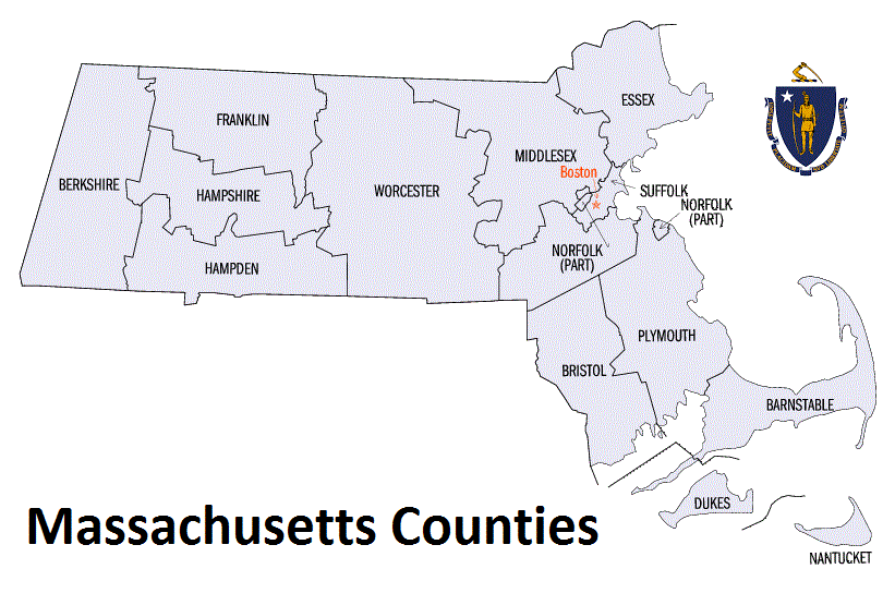
Map of Massachusetts Counties