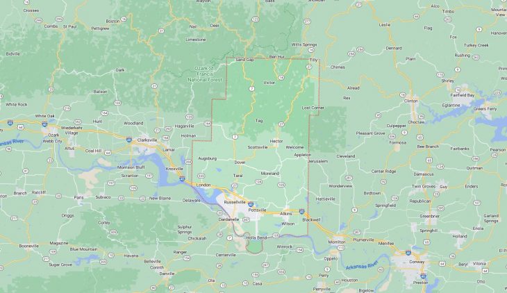
Cities and Towns in Pope County, Arkansas
Founded on November 2, 1829, Pope County is one of 75 counties in the state of Arkansas. Historically, Pope County was formed from Crawford County. The city of Russellville is the county seat. With FIPS code of 115, Pope County has a population of 63,789 and area of 830.79 square miles (2,152 km²).
List of all cities in Pope County, AR alphabetically
City/Town | Postal Code | Area Code |
Appleton, AR | 72823 | 479 |
Atkins, AR | 72823 | 479 |
Blackwell, AR | 72823 | 479 |
Dover, AR | 72837 | 479 |
Hector, AR | 72843 | 479 |
London, AR | 72847 | 479 |
Pottsville, AR | 72858 | 479 |
Russellville, AR | 72801 | 479 |
72802 | 479 | |
72811 | 479 | |
72812 | 479 | |
Tilly, AR | 72679 | 870 |
Major Cities and Towns in Pope County, Arkansas
Russellville
- Area: 28.3 square miles
- Population: 29,338 (2020 Census)
- ZIP Codes: 72801, 72802, 72811, 72812
- Latitude and Longitude: 35.2784° N, 93.1338° W
Location and History
Russellville, the largest city and county seat of Pope County, is located in the Arkansas River Valley between the Ozark and Ouachita Mountains. The city was founded in 1834 and named after Dr. Thomas Russell, an early settler who was instrumental in the community’s development. Russellville grew rapidly due to its strategic location along the Arkansas River and later as a stop on the Little Rock and Fort Smith Railroad. The city’s economy has traditionally been driven by agriculture, timber, and transportation, but it diversified significantly with the construction of Arkansas Nuclear One, the state’s only nuclear power plant, in the 1970s. Russellville is also home to Arkansas Tech University, which has been a major influence on the city’s growth and development. Today, Russellville is a vibrant community with a diverse economy, strong educational institutions, and a rich cultural heritage.
Major Schools and Landmarks
Russellville is served by the Russellville School District, which includes Russellville High School, known for its strong academic programs and extracurricular activities. Arkansas Tech University is a major educational and cultural hub in the city, offering a wide range of undergraduate and graduate programs. Major landmarks in Russellville include Lake Dardanelle State Park, a popular destination for fishing, boating, and camping, and the Historic Missouri-Pacific Railroad Depot, which reflects the city’s early transportation history. The city’s downtown area features a variety of shops, restaurants, and historic buildings, contributing to its charm and appeal. Additionally, the Arkansas River provides opportunities for outdoor recreation and scenic views, making Russellville a well-rounded community with a rich blend of history, education, and natural beauty.
Dardanelle
- Area: 4.2 square miles
- Population: 4,745 (2020 Census)
- ZIP Codes: 72834
- Latitude and Longitude: 35.2226° N, 93.1577° W
Location and History
Dardanelle is one of the oldest cities in Arkansas, located directly across the Arkansas River from Russellville in Yell County, though its historical and economic ties to Pope County are strong. The city was established in the early 19th century and grew as a major river port, benefiting from its strategic location at the confluence of the Arkansas and Petit Jean Rivers. Dardanelle played a significant role in the transportation of goods, particularly cotton and other agricultural products, which were shipped via the river to larger markets. The city’s rich history is reflected in its well-preserved downtown area, which features several historic buildings dating back to the 19th century. Today, Dardanelle is a small but vibrant community that retains much of its historical charm while serving as a gateway to the surrounding natural beauty of the Arkansas River Valley.
Major Schools and Landmarks
Dardanelle is served by the Dardanelle School District, which includes Dardanelle High School, known for its strong academic programs and involvement in local sports and community activities. Major landmarks in Dardanelle include the Dardanelle Rock, a prominent geological formation that was a landmark for early river travelers and has historical significance to the area. The city’s historic downtown district offers a glimpse into its past with buildings that house local businesses, shops, and restaurants. Mount Nebo State Park, located just outside the city, is a major attraction offering hiking, camping, and breathtaking views of the Arkansas River Valley. The Dardanelle Lock and Dam, part of the McClellan-Kerr Arkansas River Navigation System, is another significant landmark that underscores the city’s longstanding relationship with the Arkansas River.
Atkins
- Area: 5.2 square miles
- Population: 3,058 (2020 Census)
- ZIP Codes: 72823
- Latitude and Longitude: 35.2445° N, 92.9362° W
Location and History
Atkins is a small city located in the eastern part of Pope County, Arkansas. The city was established in 1872 and was named after Elisha Atkins, a railroad executive. Atkins grew rapidly due to its location along the Little Rock and Fort Smith Railroad, which made it an important shipping point for agricultural products, particularly pickles. The city became famous for its pickle production, earning it the nickname “Pickle Capital of Arkansas.” For much of the 20th century, the Atkins Pickle Company was the largest employer in the city, and the annual Picklefest celebrates this unique heritage. Although the pickle industry has since declined, Atkins remains a close-knit community with a strong agricultural base and a rich history.
Major Schools and Landmarks
Atkins is served by the Atkins School District, which includes Atkins High School, known for its academic programs and active participation in local sports. The city is home to several landmarks that reflect its agricultural heritage, including the historic Atkins Pickle Company building, which stands as a testament to the city’s past. The annual Atkins Picklefest is a major event that brings the community together to celebrate its history with parades, live music, and, of course, pickles. The city is also close to Lake Atkins, a popular spot for fishing, boating, and picnicking. The Atkins Commercial Historic District, listed on the National Register of Historic Places, features several buildings from the late 19th and early 20th centuries, providing a glimpse into the city’s past.
Dover
- Area: 2.5 square miles
- Population: 1,378 (2020 Census)
- ZIP Codes: 72837
- Latitude and Longitude: 35.4006° N, 93.1141° W
Location and History
Dover is a small town located north of Russellville in Pope County, Arkansas. The town was established in the mid-19th century and served as a local trading center for the surrounding rural areas. Dover’s growth was modest, primarily driven by agriculture, with farming and timber being the main economic activities. The town’s location along Arkansas Highway 7 made it a convenient stop for travelers and contributed to its development as a small but vibrant community. Over the years, Dover has maintained its rural charm while gradually expanding its residential and commercial areas. The town is known for its friendly atmosphere, strong community spirit, and close ties to the natural beauty of the Ozark Mountains.
Major Schools and Landmarks
Dover is served by the Dover School District, which includes Dover High School, known for its supportive educational environment and active involvement in local sports and extracurricular activities. Major landmarks in Dover include the Dover City Park, a popular gathering spot for community events, sports, and picnics. The town is also close to the Ozark National Forest, offering residents and visitors access to outdoor activities such as hiking, camping, and fishing. The nearby Long Pool Recreation Area, located within the national forest, is a favorite spot for swimming and picnicking, highlighting Dover’s appeal as a gateway to the natural beauty of the Ozarks. The town’s annual community events, such as the Dover Days Festival, celebrate its rural heritage and bring residents together in a display of local pride.
London
- Area: 3.2 square miles
- Population: 1,039 (2020 Census)
- ZIP Codes: 72847
- Latitude and Longitude: 35.3193° N, 93.2527° W
Location and History
London is a small town located in western Pope County, Arkansas, near Lake Dardanelle. The town was established in the late 19th century and was named after London, England, by a local settler who admired the British capital. London grew as an agricultural community, with its economy primarily based on farming and timber. The town’s proximity to the Arkansas River and later to Lake Dardanelle contributed to its development as a local hub for trade and transportation. Over the years, London has remained a small, rural community with a strong emphasis on family and tradition. The town’s location near the lake and the Ozark Mountains makes it an attractive place for those seeking a quiet, scenic environment with easy access to outdoor recreation.
Major Schools and Landmarks
London is part of the Russellville School District, with students attending schools in nearby Russellville. The town is known for its peaceful atmosphere and close-knit community. Major landmarks in London include the London City Park, which offers facilities for sports, picnics, and community gatherings. The town’s proximity to Lake Dardanelle State Park provides opportunities for fishing, boating, and camping, making it a popular destination for outdoor enthusiasts. The London Bridge, a historic bridge that once spanned the Arkansas River, is another notable landmark that reflects the town’s rich history, although it is no longer in use. The town’s annual London Day event brings the community together to celebrate its history and culture with parades, music, and local food, reinforcing the town’s strong sense of identity and community spirit.
Hector
- Area: 1.0 square mile
- Population: 505 (2020 Census)
- ZIP Codes: 72843
- Latitude and Longitude: 35.4637° N, 92.9735° W
Location and History
Hector is a small town located in the northern part of Pope County, Arkansas, near the Ozark National Forest. The town was established in the late 19th century and was named after a local landowner. Hector developed as a farming community, with agriculture, particularly livestock and poultry farming, serving as the primary economic activities. The town’s remote location in the foothills of the Ozarks has allowed it to retain its rural character and close-knit community atmosphere. Hector’s history is closely tied to the land, with generations of families living and working in the area for decades. Despite its small size, Hector is known for its strong sense of community and connection to the natural environment.
Major Schools and Landmarks
Hector is served by the Hector School District, which includes Hector High School and Hector Elementary School. The schools are central to the community, providing education and extracurricular activities for the town’s youth. Significant landmarks in Hector include the Hector Community Center, which hosts local events and gatherings, and the nearby Ozark National Forest, which offers a wide range of outdoor activities such as hiking, camping, and fishing. The nearby Big Piney Creek, known for its clear waters and scenic beauty, is a popular spot for canoeing and kayaking, attracting visitors from across the region. Hector’s annual community events, such as the Hector Homecoming, bring residents together to celebrate their heritage and strengthen the bonds of the community. The town’s rural charm, natural beauty, and strong community spirit make it a unique and appealing place to live in Pope County.