Cities and Towns in Woodruff County, Arkansas

Founded on November 26, 1862, Woodruff County is one of 75 counties in the state of Arkansas. Historically, Woodruff County was formed from Jackson and St. Francis counties. The city of Augusta is the county seat. With FIPS code of 147, Woodruff County has a population of 6,116 and area of 594.05 square miles (1,539 km²).

List of all cities in Woodruff County, AR alphabetically

City/Town Postal Code Area Code
Augusta, AR 72006 870
Cotton Plant, AR 72036 870
Fair Oaks, AR 72101 870
Grays, AR 72101 870
Gregory, AR 72059 870
Hillemann, AR 72101 870
Howell, AR 72101 870
Hunter, AR 72074 870
Maberry, AR 72036 870
McCrory, AR 72101 870
Morton, AR 72101 870
Patterson, AR 72123 870
Pumpkin Bend, AR 72101 870
Riverside, AR 72101 870
Wiville, AR 72101 870

Major Cities and Towns in Woodruff County, Arkansas

Augusta

  • Area: 1.9 square miles
  • Population: 2,254 (as of the 2020 Census)
  • Zip Codes: 72006
  • Latitude and Longitude: 34.3651° N, 91.5314° W

Location and History

Augusta is located in the southeastern part of Woodruff County along the White River. Founded in 1854, Augusta played a significant role in the region’s history as a key river town. The city’s location on the river contributed to its development as a commercial and transportation hub in the 19th and early 20th centuries. Augusta’s history is marked by its growth during the cotton boom and its role as a center for local trade. The town has evolved over time while maintaining its historical roots and significance within Woodruff County.

Major Schools and Landmarks

Augusta is served by the Augusta School District, which includes Augusta High School and Augusta Middle School. Major landmarks in Augusta include the historic Augusta Depot, reflecting the town’s historical significance in transportation, and the White River Historical Society Museum, which showcases the region’s history and heritage. The town is also known for its annual events and community gatherings that celebrate its local culture and history. Augusta’s blend of historical sites and modern amenities make it a central part of Woodruff County.

McCrory

  • Area: 1.2 square miles
  • Population: 1,739 (as of the 2020 Census)
  • Zip Codes: 72101
  • Latitude and Longitude: 34.4915° N, 91.3483° W

Location and History

McCrory is located in the southwestern part of Woodruff County. Established in the early 20th century, the town was named after the McCrory family who were early settlers in the area. McCrory’s growth was closely tied to local agriculture, especially cotton farming, which shaped its early economy. The town has maintained its agricultural roots while developing into a key community center within the county. McCrory’s history reflects its evolution from a small agricultural settlement to a vibrant local hub.

Major Schools and Landmarks

McCrory is served by the McCrory School District, which includes McCrory High School and McCrory Middle School. Notable landmarks include the historic McCrory High School Building, an example of early 20th-century educational architecture, and the Woodruff County Fairgrounds, which hosts various community events and agricultural exhibitions. The town’s historical sites and community institutions highlight its agricultural heritage and role as a central part of Woodruff County.

Cotton Plant

  • Area: 1.0 square mile
  • Population: 953 (as of the 2020 Census)
  • Zip Codes: 72036
  • Latitude and Longitude: 34.4404° N, 91.3392° W

Location and History

Cotton Plant is situated in the northwestern part of Woodruff County. Founded in the late 19th century, the town’s name reflects its historical connection to cotton production, which was central to its early economy. Cotton Plant has a history of serving as a local trade and agricultural center. Its development was closely tied to the expansion of cotton farming in the region, and it has remained a small but significant community within the county. The town’s historical roots are evident in its preserved architecture and local traditions.

Major Schools and Landmarks

Cotton Plant is served by the Cotton Plant School District, which includes Cotton Plant High School and Cotton Plant Middle School. Significant landmarks include the Cotton Plant City Hall and the Cotton Plant Historical Museum, which offer insights into the town’s agricultural past and community history. The town’s location provides access to nearby natural areas, reflecting its rural and agricultural character. Cotton Plant’s blend of historical sites and community events highlights its role in Woodruff County’s local culture and heritage.

Wabbaseka

  • Area: 0.8 square miles
  • Population: 489 (as of the 2020 Census)
  • Zip Codes: 72175
  • Latitude and Longitude: 34.4697° N, 91.3345° W

Location and History

Wabbaseka is located in the southeastern part of Woodruff County. Established in the late 19th century, the town was named after a local Native American term, reflecting its early cultural influences. Wabbaseka’s history is closely tied to its agricultural roots and its role as a small but important community in the region. The town has evolved over time while maintaining its historical and cultural significance within Woodruff County.

Major Schools and Landmarks

Wabbaseka is served by the Wabbaseka School District, which includes Wabbaseka High School and Wabbaseka Middle School. Key landmarks include the Wabbaseka Community Center, which hosts various local events, and the Wabbaseka Historical Society, which preserves the town’s history and heritage. The town’s location and community-focused institutions reflect its agricultural roots and cultural significance within Woodruff County.

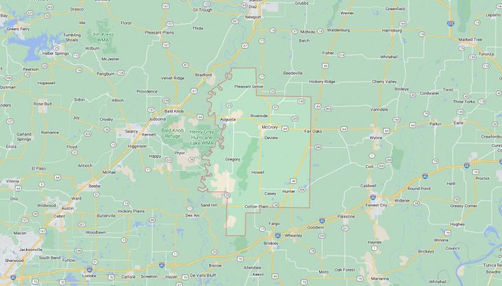
Map of Cities in Woodruff County, AR

Map of Cities in Woodruff County, AR