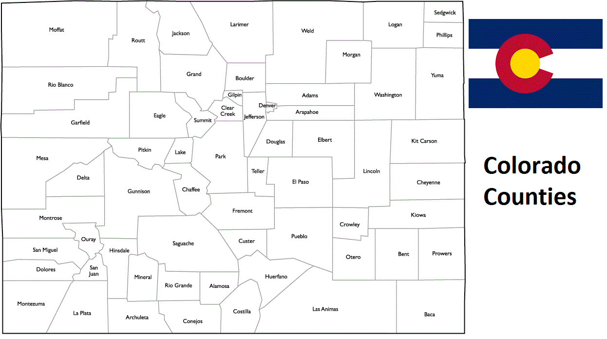
Colorado Counties List
There are a total of 64 counties in the state of Colorado. Among them, Arapahoe County is the oldest one (established in 1861) while Broomfield is the youngest (established in 2001). With population of 622,263, El Paso County is the most populated. The biggest county by land area is Las Animas County (12,363 km²) and the smallest is Broomfield (87 km²).
Largest Counties in Colorado
1. Las Animas County
County Seat: Trinidad
- Area: 4,775 square miles
- Population: Approximately 14,555 (2020 census)
- Area Codes: 719
- Latitude: 37.1695° N
- Longitude: 104.5005° W
Location and History
Las Animas County is the largest county in Colorado by area, located in the southern part of the state along the New Mexico border. Established on February 9, 1866, the county was named after the Spanish phrase “Las Ánimas,” meaning “the souls.” The county seat, Trinidad, became a significant stop on the Santa Fe Trail during the 19th century, contributing to its growth as a center for trade and culture in the region. The area’s history is deeply tied to coal mining, ranching, and agriculture, which drove much of its economic development in the late 19th and early 20th centuries.
Major Highways and Landmarks
Las Animas County is intersected by Interstate 25, which runs north-south through the county, connecting Trinidad to Colorado Springs and New Mexico. U.S. Highway 160 also traverses the county, providing an east-west route. Notable landmarks include the Trinidad Lake State Park, offering outdoor recreation such as boating, fishing, and hiking, and the historic Santa Fe Trail, which passes through the county. The Spanish Peaks, a pair of prominent mountains, are another significant natural landmark. Additionally, the Ludlow Massacre Memorial commemorates the tragic 1914 labor conflict that occurred near the town of Ludlow.
2. Moffat County
County Seat: Craig
- Area: 4,751 square miles
- Population: Approximately 13,292 (2020 census)
- Area Codes: 970
- Latitude: 40.5152° N
- Longitude: 107.5467° W
Location and History
Moffat County is located in the northwestern corner of Colorado, bordering Utah and Wyoming. The county was established on February 27, 1911, and named after David H. Moffat, a prominent Colorado railroad builder. The county seat, Craig, developed as a key community in the region due to its strategic location along the Yampa River and its proximity to coal mining operations. The county’s history is tied to agriculture, ranching, and mining, with these industries continuing to play a vital role in the local economy.
Major Highways and Landmarks
Moffat County is accessible via U.S. Highway 40, which runs east-west through the county and connects Craig to other parts of Colorado and Utah. State Highway 13 provides a north-south route through the county. Significant landmarks include Dinosaur National Monument, known for its rich fossil beds and stunning canyon scenery, and the Browns Park National Wildlife Refuge, which offers critical habitat for wildlife and opportunities for outdoor recreation. The Sand Wash Basin, a remote area known for its wild horse herds, is another notable feature of the county.
3. Weld County
County Seat: Greeley
- Area: 4,017 square miles
- Population: Approximately 328,981 (2020 census)
- Area Codes: 970
- Latitude: 40.4233° N
- Longitude: 104.7091° W
Location and History
Weld County is located in the northeastern part of Colorado, encompassing part of the Denver-Aurora-Lakewood metropolitan area. It was established on November 1, 1861, and named after Lewis Ledyard Weld, the first Secretary of the Colorado Territory. Greeley, the county seat, was founded as a utopian farming community in 1869 and has since grown into a regional center for agriculture, education, and industry. The county’s economy is heavily based on agriculture, particularly cattle ranching and crop production, as well as oil and gas extraction.
Major Highways and Landmarks
Weld County is served by major highways such as Interstate 25, which runs along the western edge of the county, and U.S. Highways 34, 85, and 287, which provide critical connections to nearby cities and states. Key landmarks include the Pawnee National Grassland, known for its wide-open prairies, hiking trails, and birdwatching opportunities, and the Centennial Village Museum in Greeley, which showcases the history of the region through preserved buildings and artifacts. The Colorado Model Railroad Museum and the Union Colony Civic Center in Greeley are also significant cultural attractions in the county.
4. Garfield County
County Seat: Glenwood Springs
- Area: 2,956 square miles
- Population: Approximately 61,685 (2020 census)
- Area Codes: 970
- Latitude: 39.5505° N
- Longitude: 107.3247° W
Location and History
Garfield County is located in the western part of Colorado, stretching from the Rocky Mountains to the Utah border. The county was established on February 10, 1883, and named after President James A. Garfield. Glenwood Springs, the county seat, is renowned for its hot springs and scenic beauty, making it a popular destination for tourists. The county’s history is closely linked to mining, particularly coal, as well as agriculture and tourism. The discovery of natural gas reserves in recent decades has further diversified the county’s economy.
Major Highways and Landmarks
Garfield County is traversed by Interstate 70, which runs east-west through the county, connecting it to Denver and Grand Junction. U.S. Highways 6 and 24 also serve the area. Significant landmarks include the Glenwood Hot Springs, one of the largest hot springs pools in the world, and the Hanging Lake, a stunningly clear turquoise lake located in Glenwood Canyon. The Roaring Fork Valley, known for its outdoor recreational opportunities, including skiing, hiking, and fishing, is another key feature of the county. The county’s rugged terrain and scenic vistas make it a prime destination for nature enthusiasts.
5. Routt County
County Seat: Steamboat Springs
- Area: 2,368 square miles
- Population: Approximately 24,829 (2020 census)
- Area Codes: 970
- Latitude: 40.4875° N
- Longitude: 106.8317° W
Location and History
Routt County is located in the northwestern part of Colorado, known for its mountainous terrain and outdoor recreation opportunities. The county was established on January 29, 1877, and named after John Long Routt, the first Governor of Colorado. Steamboat Springs, the county seat, was founded as a resort town in the late 19th century, famous for its natural hot springs and later for its world-class skiing. The county’s history is marked by its development as a destination for tourism, ranching, and more recently, outdoor sports such as skiing and mountain biking.
Major Highways and Landmarks
Routt County is served by U.S. Highway 40, which runs through Steamboat Springs and provides access to other parts of the state and neighboring Utah. Key landmarks include the Steamboat Ski Resort, one of the most popular ski destinations in Colorado, and the Strawberry Park Hot Springs, offering natural thermal pools in a picturesque mountain setting. The Yampa River, which flows through the county, is known for its excellent fishing and rafting opportunities. The Routt National Forest, which covers much of the county, provides additional outdoor recreation opportunities, including hiking, camping, and wildlife viewing.
6. Rio Blanco County
County Seat: Meeker
- Area: 3,223 square miles
- Population: Approximately 6,529 (2020 census)
- Area Codes: 970
- Latitude: 40.0428° N
- Longitude: 107.9055° W
Location and History
Rio Blanco County is located in the northwestern part of Colorado, bordering Utah. The county was established on March 25, 1889, and named after the White River (“Rio Blanco” in Spanish), which flows through the region. Meeker, the county seat, was founded in the late 19th century and has a history rooted in ranching and agriculture. The area was also the site of the Meeker Massacre in 1879, a conflict between the U.S. government and the Ute tribe that led to the establishment of the Ute Indian Reservation in southwestern Colorado.
Major Highways and Landmarks
Rio Blanco County is accessible via State Highway 13, which runs north-south through the county and connects Meeker to other parts of Colorado and Utah. U.S. Highway 40 also provides east-west access across the region. Significant landmarks include the Flat Tops Wilderness Area, known for its distinctive flat-topped mountains and extensive hiking trails. The White River National Forest, which covers much of the county, offers opportunities for outdoor activities such as hunting, fishing, and camping. The county is also home to the Meeker Classic Sheepdog Championship Trials, an annual event that attracts visitors from around the world.
7. Gunnison County
County Seat: Gunnison
- Area: 3,260 square miles
- Population: Approximately 16,918 (2020 census)
- Area Codes: 970
- Latitude: 38.5458° N
- Longitude: 106.9253° W
Location and History
Gunnison County is located in the heart of Colorado’s Rocky Mountains, known for its rugged terrain and outdoor recreation opportunities. The county was established on March 9, 1877, and named after John W. Gunnison, an Army officer and explorer who surveyed the region in the mid-19th century. The county seat, Gunnison, developed as a mining and ranching town, and later became a center for education with the founding of Western Colorado University. The county’s economy is now largely driven by tourism, particularly skiing, mountain biking, and other outdoor activities.
Major Highways and Landmarks
Gunnison County is served by U.S. Highway 50, which runs east-west through the county and connects Gunnison to other parts of Colorado. State Highway 135 provides access to Crested Butte, a major ski resort town in the county. Significant landmarks include the Black Canyon of the Gunnison National Park, known for its steep cliffs and dramatic landscapes, and the Curecanti National Recreation Area, which offers boating, fishing, and camping along the Gunnison River. The county is also home to the Maroon Bells-Snowmass Wilderness, one of the most photographed mountain ranges in North America.
8. Saguache County
County Seat: Saguache
- Area: 3,170 square miles
- Population: Approximately 6,368 (2020 census)
- Area Codes: 719
- Latitude: 38.0864° N
- Longitude: 106.1310° W
Location and History
Saguache County is located in south-central Colorado, within the San Luis Valley. The county was established on December 29, 1866, and its name is derived from a Ute word meaning “blue earth” or “water at blue earth.” Saguache, the county seat, has a rich history tied to mining, ranching, and agriculture. The county’s early economy was driven by the discovery of gold and silver in the nearby mountains, but it later shifted towards agriculture, particularly potato farming, due to the fertile soils of the San Luis Valley.
Major Highways and Landmarks
Saguache County is accessible via U.S. Highway 285, which runs north-south through the county, and State Highway 17. Key landmarks include the Great Sand Dunes National Park and Preserve, which features the tallest sand dunes in North America and offers unique recreational opportunities such as sandboarding and hiking. The Sangre de Cristo Mountains, which border the county to the east, provide stunning scenery and opportunities for outdoor activities. The county is also home to the San Luis Valley Museum in Saguache, which preserves the history and culture of the region.
9. Delta County
County Seat: Delta
- Area: 1,149 square miles
- Population: Approximately 31,196 (2020 census)
- Area Codes: 970
- Latitude: 38.7428° N
- Longitude: 108.0697° W
Location and History
Delta County is located in western Colorado, within the Colorado Plateau region. The county was established on February 11, 1883, and named after the river delta formed by the confluence of the Gunnison and Uncompahgre Rivers. Delta, the county seat, developed as a key agricultural and trading center in the region. The county’s history is closely tied to farming, ranching, and fruit growing, particularly apples and peaches, which thrive in the area’s fertile soils and favorable climate.
Major Highways and Landmarks
Delta County is served by U.S. Highway 50, which runs through Delta and provides access to other parts of Colorado. State Highway 92 offers a scenic route along the North Fork of the Gunnison River. Significant landmarks include the Grand Mesa, the largest flat-topped mountain in the world, offering opportunities for skiing, hiking, and fishing in its numerous lakes. The Black Canyon of the Gunnison National Park, with its dramatic cliffs and deep gorges, is another major attraction in the county. The Delta County Historical Society Museum in Delta preserves the region’s pioneer heritage.
10. Park County
County Seat: Fairplay
- Area: 2,211 square miles
- Population: Approximately 17,390 (2020 census)
- Area Codes: 719
- Latitude: 39.2250° N
- Longitude: 106.0005° W
Location and History
Park County is located in central Colorado, within the South Park basin, a high-altitude grassland surrounded by mountains. The county was established on November 1, 1861, and named after the geographic feature of South Park. Fairplay, the county seat, was founded as a mining town during the Colorado Gold Rush and has preserved much of its historic character. The county’s history is closely tied to mining, ranching, and agriculture, with these industries shaping its development over the years.
Major Highways and Landmarks
Park County is traversed by U.S. Highways 285 and 24, which provide access to Denver and other parts of Colorado. State Highway 9 runs through the county, connecting Fairplay to Breckenridge. Key landmarks include Mount Evans, one of Colorado’s famous “fourteeners” (peaks over 14,000 feet), and the Pike National Forest, offering extensive opportunities for hiking, camping, and wildlife viewing. The South Park City Museum in Fairplay is a restored 19th-century mining town, providing visitors with a glimpse into the county’s gold rush past. The county’s scenic beauty and historical significance make it a popular destination for tourists and outdoor enthusiasts alike.
List of All Counties in Colorado
Below please see all Colorado counties which are listed in alphabetical order.
- Adams County, CO
- Alamosa County, CO
- Arapahoe County, CO
- Archuleta County, CO
- Baca County, CO
- Bent County, CO
- Boulder County, CO
- City and County of Broomfield, CO
- Chaffee County, CO
- Cheyenne County, CO
- Clear Creek County, CO
- Conejos County, CO
- Costilla County, CO
- Crowley County, CO
- Custer County, CO
- Delta County, CO
- City and County of Denver, CO
- Dolores County, CO
- Douglas County, CO
- Eagle County, CO
- Elbert County, CO
- El Paso County, CO
- Fremont County, CO
- Garfield County, CO
- Gilpin County, CO
- Grand County, CO
- Gunnison County, CO
- Hinsdale County, CO
- Huerfano County, CO
- Jackson County, CO
- Jefferson County, CO
- Kiowa County, CO
- Kit Carson County, CO
- Lake County, CO
- La Plata County, CO
- Larimer County, CO
- Las Animas County, CO
- Lincoln County, CO
- Logan County, CO
- Mesa County, CO
- Mineral County, CO
- Moffat County, CO
- Montezuma County, CO
- Montrose County, CO
- Morgan County, CO
- Otero County, CO
- Ouray County, CO
- Park County, CO
- Phillips County, CO
- Pitkin County, CO
- Prowers County, CO
- Pueblo County, CO
- Rio Blanco County, CO
- Rio Grande County, CO
- Routt County, CO
- Saguache County, CO
- San Juan County, CO
- San Miguel County, CO
- Sedgwick County, CO
- Summit County, CO
- Teller County, CO
- Washington County, CO
- Weld County, CO
- Yuma County, CO