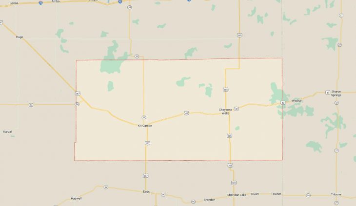
Cities and Towns in Cheyenne County, Colorado
Founded on 1889-03-25, Cheyenne County is one of 64 counties in the state of Colorado. Historically, Cheyenne County was split from Elbert and Bent counties. The city of Cheyenne Wells is the county seat. With FIPS code of 17, Cheyenne County has a population of 1,707 and area of 1,781.90 square miles (4,615 km²)
List of all cities in Cheyenne County, CO alphabetically
| City/Town | Postal Code | Area Code |
| Arapahoe, CO | 80802 | 719 |
| Aroya, CO | 80862 | 719 |
| Cheyenne Wells, CO | 80810 | 719 |
| First View, CO | 80810 | 719 |
| Kit Carson, CO | 80825 | 719 |
| Wild Horse, CO | 80862 | 719 |
Major Cities and Towns in Cheyenne County, Colorado
Cheyenne Wells
Area, Population, Zip Codes, and Coordinates
- Area: 1.1 square miles
- Population: Approximately 800 (2023 estimate)
- Zip Codes: 80810
- Latitude and Longitude: 38.8219° N, 102.3519° W
Location and History
Cheyenne Wells is the county seat and largest town in Cheyenne County, located in the eastern plains of Colorado near the Kansas border. The town was established in 1870 and named after the Cheyenne people, who originally inhabited the area. The “Wells” part of the name comes from the natural springs that were vital for the survival of early settlers and travelers. Cheyenne Wells developed as a key stop along the Kansas Pacific Railway, which facilitated the transport of agricultural products and goods, contributing to the town’s growth. Over the years, Cheyenne Wells has maintained its agricultural roots, with farming and ranching continuing to be the mainstays of the local economy. The town’s location on the plains provides a vast, open landscape, typical of eastern Colorado.
Major Schools and Landmarks
Cheyenne Wells is served by the Cheyenne County School District RE-5, with Cheyenne Wells High School and Cheyenne Wells Elementary School being the primary educational institutions. Significant landmarks in Cheyenne Wells include the Cheyenne County Courthouse, a historic building that serves as the center of local government, and the Cheyenne Wells Carousel, one of the few remaining hand-carved wooden carousels in the state, which has been beautifully restored and is a beloved community attraction. The town is also home to the Cheyenne County Museum, which preserves the history of the region with exhibits on pioneer life, agriculture, and the development of the railroad. The surrounding plains offer opportunities for hunting, bird watching, and enjoying the wide-open spaces that define the area.
Kit Carson
Area, Population, Zip Codes, and Coordinates
- Area: 0.5 square miles
- Population: Approximately 250 (2023 estimate)
- Zip Codes: 80825
- Latitude and Longitude: 38.7622° N, 102.7942° W
Location and History
Kit Carson is a small town located in the northern part of Cheyenne County, named after the famous American frontiersman Christopher “Kit” Carson. The town was established in 1886 as a stop along the Rock Island Railroad, which played a crucial role in its development. Kit Carson served as a supply point for the surrounding ranching and farming communities, with its economy largely based on agriculture. The town has preserved its historical character, with many of its original buildings still standing. Despite its small size, Kit Carson holds an important place in the history of the region, reflecting the pioneer spirit that characterized the settlement of the American West.
Major Schools and Landmarks
Kit Carson is served by the Kit Carson School District R-1, with Kit Carson School providing education from kindergarten through 12th grade. Key landmarks in Kit Carson include the Kit Carson Museum, which offers exhibits on the town’s history, including its connection to the railroad and the agricultural development of the area. The town’s historic downtown features several preserved buildings from the late 19th and early 20th centuries, giving visitors a glimpse into its past. The surrounding landscape, with its expansive fields and rolling plains, provides opportunities for outdoor activities such as hunting and bird watching. Kit Carson’s small-town charm and historical significance make it a unique and welcoming community in Cheyenne County.
Wild Horse
Area, Population, Zip Codes, and Coordinates
- Area: N/A (unincorporated community)
- Population: Approximately 10 (2023 estimate)
- Zip Codes: 80862
- Latitude and Longitude: 38.8336° N, 103.0136° W
Location and History
Wild Horse is a tiny, unincorporated community located in the western part of Cheyenne County. The community was established in the early 1900s, originally serving as a stop along the Missouri Pacific Railroad. The town was named “Wild Horse” due to the herds of wild mustangs that once roamed the area. Although the town never grew significantly, it served as a local hub for the surrounding ranches and farms. Today, Wild Horse is a quiet, almost forgotten place, with only a few residents remaining. The town’s history reflects the broader story of many small, rural communities on the Colorado plains that flourished during the era of railroad expansion but declined as transportation and economic patterns changed.
Major Schools and Landmarks
Wild Horse is part of the Kit Carson School District R-1, with students attending school in nearby Kit Carson. The community’s landmarks include the remnants of old buildings and the railroad infrastructure that once served as the lifeblood of the town. The area around Wild Horse is characterized by vast open plains, which provide opportunities for hunting, photography, and experiencing the solitude of the Colorado prairie. While Wild Horse may be small and largely quiet today, it offers a glimpse into the history of the rural West and the changes that have shaped the region over the past century.


