Cities and Towns in Saguache County, Colorado

Founded on 1866-12-29, Saguache County is one of 64 counties in the state of Colorado. Historically, Saguache County was split from Lake and Costilla counties. The city of Saguache is the county seat. With FIPS code of 109, Saguache County has a population of 6,471 and area of 3,168.32 square miles (8,206 km²).

List of all cities in Saguache County, CO alphabetically

City/Town Postal Code Area Code
Bonanza City, CO 81155 719
Crestone, CO 81131 719
Mirage, CO 81143 719
Moffat, CO 81143 719
Saguache, CO 81149 719
Sargents, CO 81248 970
Villa Grove, CO 81155 719
White Pine, CO 81248 970

Major Cities and Towns in Saguache County, Colorado

Saguache

Area, Population, and Geography

  • Area: 0.5 square miles
  • Population: Approximately 500 (2023 estimate)
  • Zip Codes: 81149
  • Latitude: 38.0878° N
  • Longitude: 106.1406° W

City Location and History

Saguache, the county seat of Saguache County, is located in the northern part of the San Luis Valley, at the base of the Sangre de Cristo Mountains. The town was established in 1867 and its name, derived from a Ute Indian word meaning “blue earth” or “water at the blue earth,” reflects its Native American heritage. Saguache was originally a trading post for nearby ranchers and miners, serving as a central hub for commerce and supplies in the region. The town grew as agriculture and ranching became the primary economic activities in the valley, with Saguache serving as a key service center. Today, Saguache retains its historic charm with a number of well-preserved 19th-century buildings, offering a glimpse into the region’s frontier past.

Major Schools and Landmarks

Saguache is served by the Mountain Valley School District, with Mountain Valley School being the main educational institution, offering K-12 education. The town’s major landmarks include the Saguache County Museum, which houses a collection of artifacts and exhibits related to the area’s history, including Native American artifacts, pioneer relics, and a restored stagecoach. The historic Saguache Hotel, built in the late 1800s, is another key landmark, reflecting the town’s role as a stopover for travelers in the early days of the Colorado frontier. The nearby Great Sand Dunes National Park and Preserve offers a unique natural landmark, with the tallest sand dunes in North America providing opportunities for hiking, sandboarding, and exploring the unique desert landscape. Saguache’s combination of historical significance, educational resources, and proximity to natural attractions makes it an important town in Saguache County.

Crestone

Area, Population, and Geography

  • Area: 0.6 square miles
  • Population: Approximately 150 (2023 estimate)
  • Zip Codes: 81131
  • Latitude: 37.9961° N
  • Longitude: 105.6995° W

City Location and History

Crestone is a small town located at the foot of the Sangre de Cristo Mountains in the eastern part of Saguache County. Originally established in the late 1800s as a mining town during Colorado’s gold and silver rushes, Crestone’s population dwindled after the mines were exhausted. The town experienced a resurgence in the 1970s when it became a center for spiritual retreats and alternative living. Today, Crestone is known for its vibrant spiritual community, hosting a variety of religious and spiritual centers, including Buddhist monasteries, Hindu temples, and New Age retreat centers. The town’s unique blend of natural beauty and spiritual significance has made it a destination for those seeking peace, meditation, and alternative lifestyles.

Major Schools and Landmarks

Crestone is part of the Moffat School District, with students attending schools in nearby Moffat. The town’s major landmarks include the Crestone Ziggurat, a striking structure built for spiritual reflection and meditation, and the Crestone Charter School, which offers innovative educational programs emphasizing environmental sustainability and holistic education. The Baca Grande, a nearby residential and spiritual community, is home to several retreat centers and religious institutions, reflecting Crestone’s diverse spiritual heritage. The surrounding wilderness areas, including the Great Sand Dunes National Park and the Rio Grande National Forest, offer opportunities for hiking, wildlife viewing, and connecting with nature. Crestone’s blend of spiritual retreats, educational opportunities, and stunning natural surroundings makes it a unique and serene community in Saguache County.

Moffat

Area, Population, and Geography

  • Area: 0.3 square miles
  • Population: Approximately 100 (2023 estimate)
  • Zip Codes: 81143
  • Latitude: 38.0044° N
  • Longitude: 105.9064° W

City Location and History

Moffat is a small town located in the northern part of the San Luis Valley, near the junction of U.S. Highway 285 and Colorado State Highway 17. Founded in 1890 as a railroad town, Moffat was named after David H. Moffat, a prominent Colorado railroad builder and financier. The town served as a shipping point for agricultural products, particularly potatoes and other crops grown in the fertile San Luis Valley. Moffat’s population grew rapidly during its early years, but the town experienced a decline as railroads became less central to transportation and as agricultural patterns changed. Today, Moffat is a quiet rural community, with a focus on agriculture and small-scale farming.

Major Schools and Landmarks

Moffat is served by the Moffat Consolidated School District, with Moffat School providing K-12 education. The town’s major landmarks include the historic Moffat Depot, a reminder of the town’s railroad past, and the Moffat Cemetery, which dates back to the town’s early years and offers insights into the local history. The nearby Joyful Journey Hot Springs Spa is a popular destination for relaxation and wellness, taking advantage of the natural geothermal waters of the San Luis Valley. The surrounding San Luis Valley offers stunning views of the Sangre de Cristo Mountains and opportunities for outdoor activities such as hiking, birdwatching, and stargazing. Moffat’s agricultural roots, historical significance, and tranquil rural setting make it a distinctive town in Saguache County.

Center

Area, Population, and Geography

  • Area: 0.8 square miles
  • Population: Approximately 2,300 (2023 estimate)
  • Zip Codes: 81125
  • Latitude: 37.7519° N
  • Longitude: 106.1089° W

City Location and History

Center is a small agricultural town located in the southern part of Saguache County, in the heart of the San Luis Valley. Founded in 1907, Center was established as a hub for the region’s thriving potato and vegetable farming industry. The town’s name reflects its central location within the San Luis Valley, making it a key service and distribution point for the surrounding agricultural areas. Center’s economy has long been based on agriculture, with a focus on potato farming, barley production, and other crops that thrive in the valley’s fertile soil and high altitude. The town has a diverse population, with a rich cultural heritage rooted in the agricultural traditions of the area.

Major Schools and Landmarks

Center is served by the Center Consolidated School District, which includes Haskin Elementary School, Skoglund Middle School, and Center High School. The town’s major landmarks include the Center Community Park, which serves as a gathering place for local events and recreational activities. The nearby San Luis Valley is home to several significant natural landmarks, including the Great Sand Dunes National Park, which offers unique outdoor experiences such as sandboarding, hiking, and stargazing. The Valley also boasts the Monte Vista National Wildlife Refuge, a critical habitat for migratory birds, including sandhill cranes. Center’s agricultural base, educational resources, and proximity to natural attractions make it an important and vibrant community in Saguache County.

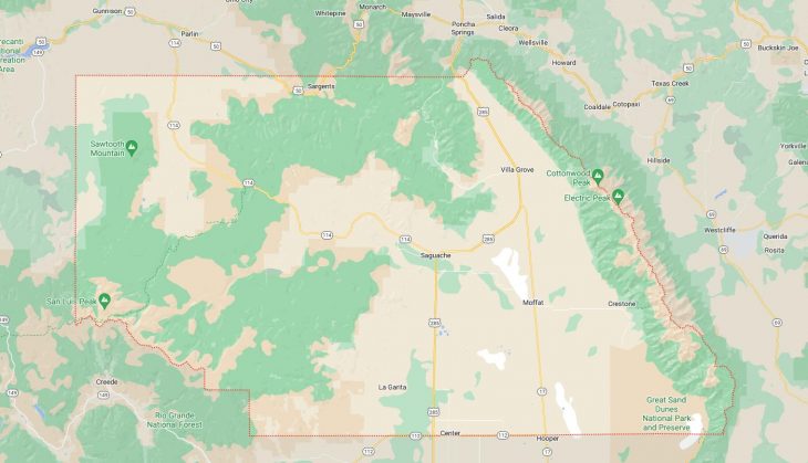
Map of Cities in Saguache County, CO

Map of Cities in Saguache County, CO