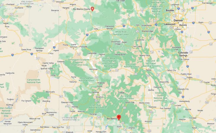
Cities and Towns in Rio Blanco County, Colorado

Founded on 1889-03-25, Rio Blanco County is one of 64 counties in the state of Colorado. Historically, Rio Blanco County was split from Garfield County. The city of Meeker is the county seat. With FIPS code of 103, Rio Blanco County has a population of 6,476 and area of 3,226.24 square miles (8,356 km²).

List of all cities in Rio Blanco County, CO alphabetically

City/Town Postal Code Area Code
Axel, CO 81641 970
Buford, CO 81641 970
Meeker, CO 81641 970
Rangely, CO 81648 970

Major Cities and Towns in Rio Blanco County, Colorado

Meeker

Area, Population, and Geography

  • Area: 3.9 square miles
  • Population: Approximately 2,400 (2023 estimate)
  • Zip Codes: 81641
  • Latitude: 40.0370° N
  • Longitude: 107.9134° W

City Location and History

Meeker is the county seat and largest town in Rio Blanco County, located in the White River Valley in northwestern Colorado. The town was founded in 1883 and named after Nathan Meeker, an Indian agent who was killed during the Meeker Massacre of 1879 at the nearby White River Indian Agency. Meeker developed as a ranching and agricultural community, with its economy initially centered on livestock and farming. The town also served as a key supply point for the surrounding ranches and farms. Over the years, Meeker has maintained its rural character and continues to be a hub for agriculture, outdoor recreation, and hunting. The town is known for its rich history, small-town charm, and proximity to the scenic Flat Tops Wilderness Area.

Major Schools and Landmarks

Meeker is served by the Meeker School District RE-1, with Meeker High School being the primary secondary school in the town. The town’s major landmarks include the White River Museum, housed in the historic Meeker Hotel, which offers exhibits on the area’s Native American history, the Meeker Massacre, and the town’s early settlers. The Meeker Classic Sheepdog Championship Trials, held annually, is a major event that draws competitors and spectators from around the world, celebrating the town’s ranching heritage. The nearby Flat Tops Wilderness Area and White River National Forest provide opportunities for hiking, fishing, hunting, and wildlife viewing. Meeker’s combination of historical significance, educational resources, and outdoor activities make it the cultural and economic center of Rio Blanco County.

Rangely

Area, Population, and Geography

  • Area: 4.0 square miles
  • Population: Approximately 2,300 (2023 estimate)
  • Zip Codes: 81648
  • Latitude: 40.0864° N
  • Longitude: 108.7987° W

City Location and History

Rangely is located in the northwestern part of Rio Blanco County, near the Utah border, along the banks of the White River. The town was originally established as a ranching community in the late 19th century, but it gained prominence in the 1940s when oil was discovered in the region. Rangely became a boomtown almost overnight, as oil companies flocked to the area to exploit the rich oil reserves. The town’s economy has since been closely tied to the energy industry, with oil and gas production remaining the primary economic drivers. Despite the fluctuations in the energy market, Rangely has developed into a stable community with a focus on education and outdoor recreation.

Major Schools and Landmarks

Rangely is served by the Rangely School District RE-4, with Rangely High School providing education for local students. The town is also home to Colorado Northwestern Community College (CNCC), which offers a variety of academic and vocational programs, including a unique aviation technology program. Rangely’s major landmarks include the Rangely Outdoor Museum, which showcases the history of the area, including its Native American heritage, early ranching days, and the development of the oil industry. The town is surrounded by vast public lands, offering opportunities for hiking, off-roading, and exploring natural attractions such as the Canyon Pintado National Historic District, which features ancient Native American rock art. Rangely’s blend of educational opportunities, outdoor activities, and a strong sense of community make it a vital town in Rio Blanco County.

Dinosaur

Area, Population, and Geography

  • Area: 0.7 square miles
  • Population: Approximately 300 (2023 estimate)
  • Zip Codes: 81610
  • Latitude: 40.2419° N
  • Longitude: 109.0087° W

City Location and History

Dinosaur is a small town located in the far western part of Rio Blanco County, near the Colorado-Utah border. The town was originally named Artesia when it was established in the early 20th century, but it was renamed Dinosaur in 1966 to capitalize on its proximity to Dinosaur National Monument. The monument, which straddles the Colorado-Utah border, is famous for its rich deposits of dinosaur fossils and its stunning geological formations. Dinosaur serves as the gateway to this national treasure, drawing visitors from around the world who come to explore the fossil beds, petroglyphs, and the rugged landscape of the monument. The town has embraced its prehistoric heritage, with many of its streets named after dinosaurs and dinosaur-themed attractions scattered throughout.

Major Schools and Landmarks

Dinosaur is served by the Rangely School District RE-4, with students attending schools in nearby Rangely. The town’s major landmarks include the Dinosaur National Monument, which offers visitors a chance to see one of the world’s most significant dinosaur fossil quarries and explore the beautiful canyons of the Green and Yampa Rivers. The monument also features numerous hiking trails, scenic drives, and opportunities for rafting and camping. The town’s Dinosaur Welcome Center provides information and exhibits related to the monument and the area’s prehistoric past. Dinosaur’s unique connection to one of the most important paleontological sites in the world, combined with its small-town charm, makes it a significant and distinctive community in Rio Blanco County.

Map of Cities in Rio Blanco County, CO

Map of Cities in Rio Blanco County, CO