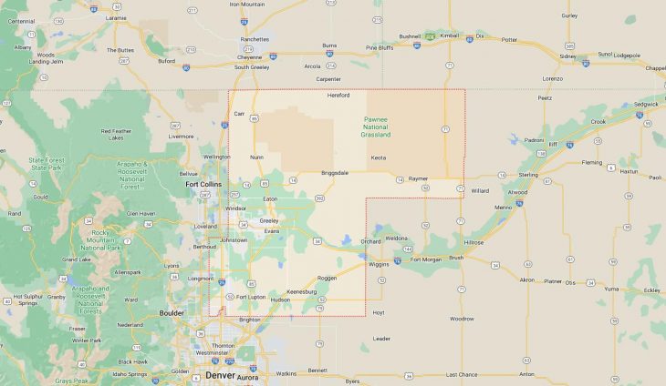
Cities and Towns in Weld County, Colorado
Founded on 1861-11-01, Weld County is one of 64 counties in the state of Colorado. The city of Greeley is the county seat. With FIPS code of 123, Weld County has a population of 340,036 and area of 4,013.84 square miles (10,396 km²).
List of all cities in Weld County, CO alphabetically
City/Town | Postal Code | Area Code |
Ault, CO | 80610 | 970 |
Briggsdale, CO | 80611 | 970 |
Brighton, CO | 80603 | 303/720 |
Carr, CO | 80612 | 970 |
Dacono, CO | 80514 | 303/720 |
Eastman Kodak Co, CO | 80551 | 970 |
Eaton, CO | 80615 | 970 |
Erie, CO | 80514 | 303/720 |
Evans, CO | 80620 | 970 |
80634 | 970 | |
80645 | 970 | |
Firestone, CO | 80504 | 303/720 |
80520 | 303/720 | |
Fort Lupton, CO | 80621 | 303/720 |
Fort Morgan, CO | 80742 | 970 |
Frederick, CO | 80504 | 303/720 |
80530 | 303/720 | |
Galeton, CO | 80622 | 970 |
Garden City, CO | 80631 | 970 |
Gilcrest, CO | 80623 | 970 |
Gill, CO | 80624 | 970 |
Greeley, CO | 80631 | 970 |
80632 | 970 | |
80633 | 970 | |
80634 | 970 | |
80638 | 970 | |
80639 | 970 | |
Grover, CO | 80729 | 970 |
Hereford, CO | 80732 | 303/720 |
Hudson, CO | 80642 | 303/720 |
Johnstown, CO | 80534 | 970 |
Keenesburg, CO | 80643 | 303/720 |
Kersey, CO | 80644 | 970 |
La Salle, CO | 80645 | 970 |
Lochbuie, CO | 80603 | 303/720 |
Longmont, CO | 80504 | 303/720 |
Loveland, CO | 80534 | 970 |
Lucerne, CO | 80646 | 970 |
Mead, CO | 80542 | 970 |
Milliken, CO | 80543 | 970 |
New Raymer, CO | 80742 | 970 |
Niwot, CO | 80504 | 303/720 |
Nunn, CO | 80648 | 970 |
Pierce, CO | 80650 | 970 |
Platteville, CO | 80651 | 970 |
Raymer, CO | 80742 | 970 |
Roggen, CO | 80652 | 303/720 |
Severance, CO | 80546 | 970 |
State Farm Ins, CO | 80638 | 970 |
Stoneham, CO | 80754 | 970 |
University of Northern Colorado, CO | 80639 | 970 |
Wattenburg, CO | 80621 | 303/720 |
Windsor, CO | 80550 | 970 |
Windsor, CO | 80551 | 970 |
Major Cities and Towns in Weld County, Colorado
Greeley
Area, Population, and Geographic Coordinates
- Area: 47.9 square miles
- Population: Approximately 108,795 (as of 2020)
- Zip Codes: 80631, 80634, 80638, 80639
- Latitude: 40.4233° N
- Longitude: 104.7091° W
Location and History
Greeley is the county seat and the largest city in Weld County, located in northern Colorado, about 50 miles north of Denver. The city was founded in 1869 as a utopian community by Nathan Meeker, an agricultural editor for the New York Tribune, and named after the newspaper’s editor, Horace Greeley. Greeley was one of the first planned communities in the western United States, established as part of the Union Colony, which sought to create a temperance-oriented, cooperative agricultural community. Over the years, Greeley has grown into a regional center for education, industry, and agriculture, with a particular emphasis on livestock and dairy farming. The city’s location along the Cache la Poudre River has made it a key agricultural hub in Colorado.
Major Schools and Landmarks
Greeley is served by the Greeley-Evans School District 6, with notable institutions including Greeley Central High School and the University of Northern Colorado. The city is home to several major landmarks, including the Centennial Village Museum, which offers a glimpse into life on the Colorado frontier, and the Greeley History Museum, which documents the city’s rich history. Island Grove Regional Park is a major recreational area, hosting events such as the Weld County Fair. The city’s vibrant downtown area features a mix of historic buildings, shops, and restaurants, reflecting Greeley’s blend of tradition and modern growth.
Evans
Area, Population, and Geographic Coordinates
- Area: 10.5 square miles
- Population: Approximately 22,165 (as of 2020)
- Zip Codes: 80620
- Latitude: 40.3753° N
- Longitude: 104.6928° W
Location and History
Evans is located immediately south of Greeley, forming part of the larger Greeley metropolitan area. The town was established in 1869, around the same time as Greeley, and was originally intended to serve as the county seat of Weld County. Named after John Evans, the second Territorial Governor of Colorado, Evans played a significant role in the early political and economic development of the region. However, a dispute over the location of the county seat led to the town’s records being stolen and moved to Greeley. Despite this early setback, Evans continued to grow, largely driven by its agricultural economy. Today, Evans is a rapidly developing city with a mix of residential, commercial, and industrial areas.
Major Schools and Landmarks
Evans is also served by the Greeley-Evans School District 6, with schools such as Dos Rios Elementary School and Prairie Heights Middle School. The city’s landmarks include Riverside Park, a popular recreational area with sports facilities, picnic areas, and trails along the South Platte River. Evans is also home to the Evans Heritage Center, which showcases the history of the city and its role in the development of Weld County. The city’s strategic location along major transportation routes has made it an attractive location for businesses, contributing to its steady growth in recent years.
Windsor
Area, Population, and Geographic Coordinates
- Area: 24.1 square miles
- Population: Approximately 32,716 (as of 2020)
- Zip Codes: 80550, 80551
- Latitude: 40.4775° N
- Longitude: 104.9011° W
Location and History
Windsor is located in the western part of Weld County, extending into neighboring Larimer County. The town was established in 1882 as a farming community, with the arrival of the Great Western Railway providing a significant boost to its economy. Windsor became known for its sugar beet industry, with the Great Western Sugar Company operating a large processing plant in the town for many years. Over time, Windsor has evolved from a small agricultural town into a rapidly growing community, attracting residents and businesses due to its proximity to Fort Collins, Loveland, and Greeley. The town has maintained its small-town charm while accommodating modern growth.
Major Schools and Landmarks
Windsor is served by the Weld RE-4 School District, with notable schools including Windsor High School and Mountain View Elementary School. The town’s major landmarks include Boardwalk Park, located on the shores of Windsor Lake, which offers swimming, boating, and a picturesque setting for community events. The historic Windsor Mill, which was partially destroyed by a fire in 2017, has been redeveloped into a mixed-use space, symbolizing the town’s blend of history and progress. Windsor’s combination of historical significance, scenic beauty, and modern amenities make it a desirable place to live in Weld County.
Fort Lupton
Area, Population, and Geographic Coordinates
- Area: 8.1 square miles
- Population: Approximately 8,038 (as of 2020)
- Zip Codes: 80621
- Latitude: 40.0833° N
- Longitude: 104.7972° W
Location and History
Fort Lupton is located in the southern part of Weld County, along the banks of the South Platte River. The town was founded in 1836 by Lieutenant Lancaster Lupton, who established a trading post that served as a key supply point for fur trappers, traders, and Native American tribes. The fort played a significant role in the early development of Colorado’s frontier economy. By the late 19th century, Fort Lupton had transitioned into a farming and ranching community, with the arrival of the railroad further boosting its growth. The town has preserved much of its historical heritage, with several buildings and sites reflecting its early days as a frontier settlement.
Major Schools and Landmarks
Fort Lupton is served by the Weld RE-8 School District, with Fort Lupton High School being the primary educational institution. The town’s major landmarks include the Fort Lupton Historic Site, where visitors can explore a reconstructed version of the original fort and learn about the area’s history. The Coyote Creek Golf Course is another popular attraction, offering a challenging course with beautiful views of the surrounding plains. The South Platte Valley Historical Society operates a museum and hosts events that celebrate the town’s rich history. Fort Lupton’s blend of historical significance and rural charm makes it a unique part of Weld County.
Frederick
Area, Population, and Geographic Coordinates
- Area: 14.6 square miles
- Population: Approximately 14,513 (as of 2020)
- Zip Codes: 80516, 80530
- Latitude: 40.1033° N
- Longitude: 104.9372° W
Location and History
Frederick is located in the southwestern part of Weld County, near the Interstate 25 corridor, which provides easy access to Denver, Boulder, and other Front Range cities. The town was established in 1907 by three brothers who named it after their father, Frederick A. Clark. Frederick was originally a coal mining town, with several mines operating in the area during the early 20th century. As the coal industry declined, Frederick transitioned into an agricultural community, with farming and dairy production becoming the mainstays of the local economy. In recent years, the town has experienced significant growth, driven by its strategic location and the development of new residential and commercial areas.
Major Schools and Landmarks
Frederick is part of the St. Vrain Valley School District, with schools such as Frederick High School and Thunder Valley K-8 serving the community. The town’s major landmarks include Crist Park, a central gathering place for community events, and the historic Frederick Town Hall, which reflects the town’s early 20th-century architecture. The Frederick Recreation Area, with its fishing ponds, trails, and picnic areas, is a popular spot for outdoor activities. Frederick’s blend of historical heritage, growing economy, and family-friendly environment make it an attractive place to live in Weld County.
Dacono
Area, Population, and Geographic Coordinates
- Area: 9.0 square miles
- Population: Approximately 6,297 (as of 2020)
- Zip Codes: 80514
- Latitude: 40.0830° N
- Longitude: 104.9408° W
Location and History
Dacono is located in the southwestern part of Weld County, along the Interstate 25 corridor, which connects it to Denver and Boulder. The town was established in 1901 by a group of settlers who combined the names of three local women—Daisy, Cora, and Nona—to form “Dacono.” Like many towns in the area, Dacono began as a coal mining community, with several mines operating in and around the town. As the mining industry declined, Dacono shifted towards agriculture and eventually grew into a residential community. Today, Dacono is part of the rapidly growing Carbon Valley region, known for its mix of small-town charm and modern amenities.
Major Schools and Landmarks
Dacono is served by the St. Vrain Valley School District, with schools such as Silver Creek Elementary School and Thunder Valley K-8 providing education to the community. Major landmarks in Dacono include Clem Dufour Park, which hosts the town’s annual summer events and provides recreational facilities for residents. The Colorado National Speedway, located just outside of town, is a popular destination for motorsports enthusiasts and hosts races throughout the year. Dacono’s convenient location, community-focused amenities, and ties to the region’s coal mining history make it a unique part of Weld County’s landscape.