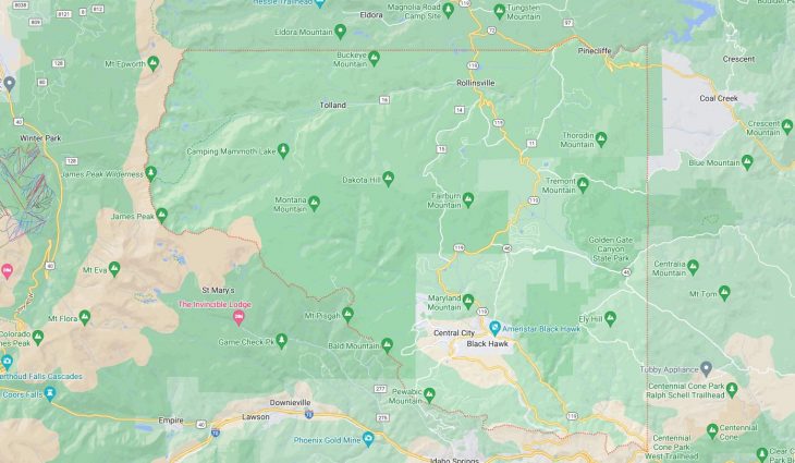
Cities and Towns in Gilpin County, Colorado

Founded on 1861-11-01, Gilpin County is one of 64 counties in the state of Colorado. The city of Central City is the county seat. With FIPS code of 47, Gilpin County has a population of 5,873 and area of 150.15 square miles (389 km²).

List of all cities in Gilpin County, CO alphabetically

City/Town Postal Code Area Code
Black Hawk, CO 80422 303/720
Central City, CO 80427 303/720
Golden, CO 80422 303/720
Rollinsville, CO 80474 303/720

Major Cities and Towns in Gilpin County, Colorado

Central City

Area, Population, Zip Codes, and Coordinates

  • Area: 2.4 square miles
  • Population: Approximately 800 (2023 estimate)
  • Zip Codes: 80427
  • Latitude and Longitude: 39.8022° N, 105.5139° W

Location and History

Central City, known as the “Richest Square Mile on Earth,” is located in the heart of Gilpin County and is one of Colorado’s oldest and most historic towns. Founded in 1859 during the Pike’s Peak Gold Rush, Central City quickly became the epicenter of Colorado’s gold mining industry. The town was named after its central location within the region’s gold mining district. During its heyday, Central City was a bustling mining town, with numerous opera houses, hotels, and saloons catering to miners and fortune seekers. Although the mining boom eventually subsided, Central City has preserved much of its historical charm and architecture, earning a place on the National Register of Historic Places. Today, it is a popular destination for tourists interested in history, gaming, and the arts.

Major Schools and Landmarks

Central City is served by the Gilpin County School District RE-1, with Gilpin County School providing K-12 education. Significant landmarks include the Central City Opera House, built in 1878, which is still in use today and hosts an annual summer opera festival. The town is also known for its historic buildings along Main Street, many of which have been restored and repurposed as casinos, maintaining the town’s legacy as a gaming hub. Other notable sites include the Teller House and the Central City Cemetery, where many of the town’s early settlers are buried, offering a window into the past.

Black Hawk

Area, Population, Zip Codes, and Coordinates

  • Area: 2.0 square miles
  • Population: Approximately 150 (2023 estimate)
  • Zip Codes: 80422
  • Latitude and Longitude: 39.8014° N, 105.4911° W

Location and History

Black Hawk is a small city located adjacent to Central City in Gilpin County. Founded around the same time as Central City in 1859, Black Hawk was also a significant player in Colorado’s gold rush era. The city was named after a Native American leader, Chief Black Hawk. Black Hawk quickly became known for its milling operations, processing gold ore from nearby mines. Over time, the town’s fortunes declined along with the gold mining industry, but a revival occurred in the 1990s when limited-stakes casino gambling was legalized. This transformation turned Black Hawk into a thriving gaming destination, with its economy largely based on tourism and hospitality.

Major Schools and Landmarks

Black Hawk shares educational facilities with nearby Central City, with students attending Gilpin County School. Major landmarks include the numerous casinos that line Black Hawk’s streets, such as the Ameristar Casino and the Isle Casino Hotel, which are some of the largest employers in the region. The city also features historical sites like the Black Hawk School, which now serves as a museum, and the restored homes and buildings that provide a glimpse into the town’s mining past. The nearby Mountain City Historic District further adds to Black Hawk’s rich historical tapestry, making it a place where history and modern entertainment intersect.

Rollinsville

Area, Population, Zip Codes, and Coordinates

  • Area: 0.6 square miles
  • Population: Approximately 200 (2023 estimate)
  • Zip Codes: 80474
  • Latitude and Longitude: 39.9111° N, 105.5006° W

Location and History

Rollinsville is a small, unincorporated community located in southern Gilpin County, near the junction of State Highway 119 and Rollins Pass. The town was named after John Q. A. Rollins, a prominent 19th-century railroad builder who envisioned creating a railroad route over the Continental Divide. Although Rollins’s railroad dreams were never fully realized, the town of Rollinsville became an important stop along the Denver, Northwestern, and Pacific Railway. Rollinsville has maintained a quiet, rural character, with its history rooted in the early railroad and mining industries. Today, it serves as a gateway to outdoor activities in the surrounding mountains and forests.

Major Schools and Landmarks

Rollinsville’s small population is served by nearby schools in Gilpin County, with students typically attending Gilpin County School in Black Hawk. Significant landmarks include the remnants of the Rollins Pass railroad, which is now a popular off-road and hiking trail offering stunning views of the Rockies. The town also serves as an access point to the Roosevelt National Forest, where visitors can enjoy camping, fishing, and hiking. Rollinsville’s historical significance is further highlighted by the preserved railroad structures and the picturesque landscapes that have changed little since the town’s early days.

Nevadaville

Area, Population, Zip Codes, and Coordinates

  • Area: N/A (Ghost Town)
  • Population: Uninhabited
  • Zip Codes: N/A
  • Latitude and Longitude: 39.7950° N, 105.5106° W

Location and History

Nevadaville is a historic ghost town located just a few miles west of Central City in Gilpin County. Founded in the early 1860s during the Colorado Gold Rush, Nevadaville was once a bustling mining town with a population that peaked at over 1,000 residents. The town was named after the silver mining district in Nevada and became one of the richest silver mining areas in the region. However, as with many boomtowns, Nevadaville’s prosperity was short-lived, and by the early 20th century, the town was largely abandoned as the mines dried up. Today, Nevadaville stands as a well-preserved ghost town, offering visitors a glimpse into Colorado’s mining past.

Major Schools and Landmarks

As a ghost town, Nevadaville no longer has schools or a resident population. The town’s primary landmarks include several well-preserved buildings, such as the Masonic Lodge and the remnants of old mining structures. The town’s cemetery is another significant site, providing insights into the lives of those who once called Nevadaville home. Visitors to the area can explore the town’s history while enjoying the scenic views of the surrounding mountains. Nevadaville’s proximity to Central City makes it an easy side trip for those interested in Colorado’s rich mining heritage, offering a stark contrast between the bustling casinos of today and the quiet echoes of the past.

Map of Cities in Gilpin County, CO

Map of Cities in Gilpin County, CO