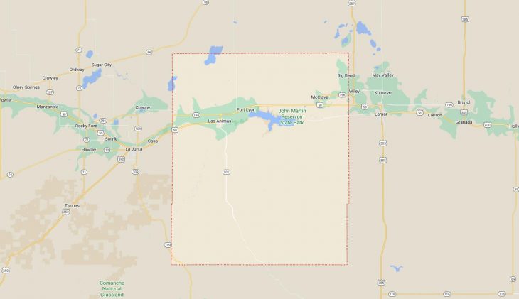
Cities and Towns in Bent County, Colorado

Founded on 1870-02-11, Bent County is one of 64 counties in the state of Colorado. Historically, Bent County was split from Huerfano County and former Cheyenne and Arapaho tribal land. The city of Las Animas is the county seat. With FIPS code of 11, Bent County has a population of 5,759 and area of 1,541.07 square miles (3,991 km²).

List of all cities in Bent County, CO alphabetically

City/Town Postal Code Area Code
Caddoa, CO 81044 719
Deora, CO 81054 719
Fort Lyon, CO 81038 719
81054 719
Hasty, CO 81044 719
John Martin Reservoir, CO 81044 719
Las Animas, CO 81054 719
Lubers, CO 81057 719
Mc Clave, CO 81057 719
Ninaview, CO 81054 719
Toonerville, CO 81054 719

Major Cities and Towns in Bent County, Colorado

Las Animas

Area, Population, Zip Codes, and Coordinates

  • Area: 1.5 square miles
  • Population: Approximately 2,000 (2023 estimate)
  • Zip Codes: 81054
  • Latitude and Longitude: 38.0667° N, 103.2233° W

Location and History

Las Animas, the county seat and largest town in Bent County, is located in southeastern Colorado along the Arkansas River. The town was established in 1869 and named after the nearby Fort Lyon, which was originally called Fort William Bent, and later renamed Fort Wise. “Las Animas” translates to “the souls” in Spanish, likely referring to the Purgatoire River (Rio de las Animas Perdidas en Purgatorio) near the town. Las Animas developed as a trading post and agricultural hub due to its strategic location along the river and the Santa Fe Trail. The town’s economy has historically been based on agriculture, with farming and ranching being the primary industries. The nearby Fort Lyon, which served as a military post and later as a veterans’ hospital, has also played a significant role in the town’s history.

Major Schools and Landmarks

Las Animas is served by the Las Animas School District RE-1, with Las Animas High School and Las Animas Elementary School being the primary educational institutions. Major landmarks in Las Animas include the Bent’s Old Fort National Historic Site, a reconstructed 1840s trading post that played a key role in the region’s history as a center for trade and cultural exchange between settlers and Native American tribes. The town is also home to the Kit Carson Museum, which showcases the life and legacy of the famous frontiersman who lived in the area. The Arkansas River and nearby John Martin Reservoir provide opportunities for outdoor recreation, including fishing, boating, and birdwatching. Las Animas’ rich history, agricultural heritage, and access to natural resources make it a central part of Bent County’s identity.

Hasty

Area, Population, Zip Codes, and Coordinates

  • Area: N/A (unincorporated community)
  • Population: Approximately 150 (2023 estimate)
  • Zip Codes: 81044
  • Latitude and Longitude: 38.1078° N, 102.9592° W

Location and History

Hasty is a small, unincorporated community located in northeastern Bent County, near the John Martin Reservoir. The community was established in the early 20th century and named after an early settler, Hasty St. John. Hasty has always been a small, rural community, primarily supporting the surrounding agricultural activities. The proximity to John Martin Reservoir has made Hasty a popular spot for outdoor enthusiasts, particularly for those interested in water-based recreation. The community remains quiet and close-knit, with its economy centered around agriculture and tourism related to the nearby reservoir.

Major Schools and Landmarks

Hasty is served by the McClave School District, with students attending McClave School in the nearby community of McClave. The most significant landmark in Hasty is the John Martin Reservoir, which is one of the largest reservoirs in Colorado and offers a wide range of recreational activities, including boating, fishing, camping, and birdwatching. The reservoir is also part of the John Martin Reservoir State Park, which provides additional facilities and outdoor opportunities. The Hasty Post Office, a small but essential hub for the community, is another key feature of this rural town. Hasty’s proximity to the reservoir and its quiet, rural character make it a peaceful retreat in Bent County.

McClave

Area, Population, Zip Codes, and Coordinates

  • Area: N/A (unincorporated community)
  • Population: Approximately 300 (2023 estimate)
  • Zip Codes: 81057
  • Latitude and Longitude: 38.1222° N, 102.8178° W

Location and History

McClave is an unincorporated community located in the northern part of Bent County. The town was established in the early 20th century and named after a prominent local family. McClave has long been a small, agricultural community, with its economy centered around farming and ranching. The town’s location on the plains of southeastern Colorado provides a rural, agricultural setting, with vast fields and open spaces surrounding the community. McClave has remained small and tightly knit, with a focus on maintaining its agricultural heritage and rural lifestyle.

Major Schools and Landmarks

McClave is home to the McClave School District, with McClave School serving students from kindergarten through 12th grade. The school is a central part of the community, often hosting local events and activities. Major landmarks in McClave include the surrounding agricultural lands, which are a key part of the town’s identity and economy. The proximity to John Martin Reservoir also provides residents with easy access to outdoor recreation, including fishing, boating, and camping. McClave’s small-town atmosphere, strong community ties, and agricultural focus make it a quintessential rural town in Bent County, offering a peaceful and supportive environment for its residents.

Fort Lyon

Area, Population, Zip Codes, and Coordinates

  • Area: N/A (unincorporated community)
  • Population: Approximately 200 (2023 estimate)
  • Zip Codes: 81054 (associated with Las Animas)
  • Latitude and Longitude: 38.0747° N, 103.1464° W

Location and History

Fort Lyon is an unincorporated community in Bent County, located near the Arkansas River and just a few miles east of Las Animas. The community grew around Fort Lyon, originally established as a U.S. Army post in 1860 to protect settlers and travelers along the Santa Fe Trail. The fort played a significant role during the Indian Wars and later served as a veterans’ hospital before transitioning to a state prison and, eventually, a facility for homeless veterans. The community of Fort Lyon developed as a result of these institutions, providing housing and services for those associated with the fort. Today, the area is quiet, with much of its history preserved through the remaining buildings and the stories of its past.

Major Schools and Landmarks

Fort Lyon is served by the Las Animas School District RE-1, with students attending schools in nearby Las Animas. The primary landmark in Fort Lyon is the historic Fort Lyon complex itself, which includes several preserved buildings from its time as a military post and hospital. These buildings, though not all accessible to the public, represent the rich history of the area and its significance in the development of southeastern Colorado. The community is also close to the Arkansas River, providing opportunities for outdoor activities such as fishing and birdwatching. Fort Lyon’s historical significance and tranquil setting make it an important part of Bent County’s heritage.

Map of Cities in Bent County, CO

Map of Cities in Bent County, CO