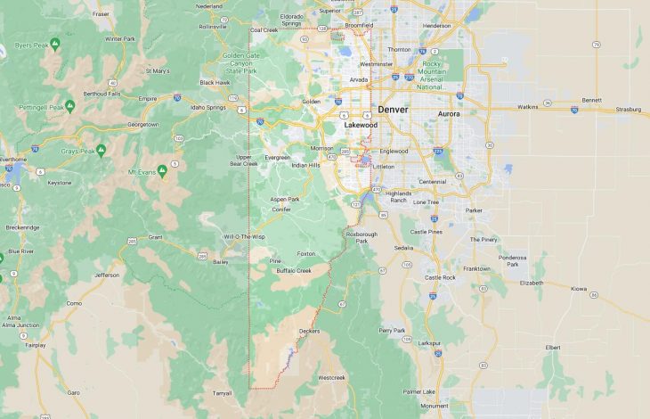
Cities and Towns in Jefferson County, Colorado
Founded on 1861-11-01, Jefferson County is one of 64 counties in the state of Colorado. Historically, Jefferson County was formed from Created as one of the 17 original counties of the Territory of Colorado. The city of Golden is the county seat. With FIPS code of 59, Jefferson County has a population of 579,581 and area of 772.85 square miles (2,002 km²).
List of all cities in Jefferson County, CO alphabetically
City/Town | Postal Code | Area Code |
Arvada, CO | 80001 | 303/720 |
80002 | 303/720 | |
80003 | 303/720 | |
80004 | 303/720 | |
80005 | 303/720 | |
80006 | 303/720 | |
80007 | 303/720 | |
80021 | 303/720 | |
80403 | 303/720 | |
Aspen Park, CO | 80433 | 303/720 |
Blackhawk, CO | 80403 | 303/720 |
Bow Mar, CO | 80123 | 303/720 |
Broomfield, CO | 80021 | 303/720 |
Buffalo Creek, CO | 80425 | 303/720 |
Centennial, CO | 80123 | 303/720 |
Columbine Valley, CO | 80123 | 303/720 |
Conifer, CO | 80433 | 303/720 |
Denver, CO | 80002 | 303/720 |
80033 | 303/720 | |
80123 | 303/720 | |
80127 | 303/720 | |
80214 | 303/720 | |
80215 | 303/720 | |
80225 | 303/720 | |
80226 | 303/720 | |
80227 | 303/720 | |
80228 | 303/720 | |
80232 | 303/720 | |
80235 | 303/720 | |
Denver Federal Center, CO | 80225 | 303/720 |
Edgewater, CO | 80214 | 303/720 |
Evergreen, CO | 80401 | 303/720 |
80437 | 303/720 | |
80439 | 303/720 | |
Foxton, CO | 80433 | 303/720 |
Golden, CO | 80401 | 303/720 |
80402 | 303/720 | |
80403 | 303/720 | |
80419 | 303/720 | |
80439 | 303/720 | |
Grants Ranch, CO | 80123 | 303/720 |
Idledale, CO | 80453 | 303/720 |
Indian Hills, CO | 80454 | 303/720 |
Jefferson County, CO | 80419 | 303/720 |
Kittredge, CO | 80457 | 303/720 |
Lakewood, CO | 80123 | 303/720 |
80214 | 303/720 | |
80215 | 303/720 | |
80225 | 303/720 | |
80226 | 303/720 | |
80227 | 303/720 | |
80228 | 303/720 | |
80232 | 303/720 | |
80235 | 303/720 | |
80401 | 303/720 | |
Littleton, CO | 80123 | 303/720 |
80127 | 303/720 | |
80128 | 303/720 | |
80162 | 303/720 | |
Morrison, CO | 80465 | 303/720 |
Pine, CO | 80470 | 303/720 |
Rollinsville, CO | 80403 | 303/720 |
Westminster, CO | 80003 | 303/720 |
80005 | 303/720 | |
80021 | 303/720 | |
Wheat Ridge, CO | 80002 | 303/720 |
80033 | 303/720 | |
80034 | 303/720 | |
80214 | 303/720 | |
80215 | 303/720 |
Major Cities and Towns in Jefferson County, Colorado
Lakewood
Area, Population, and Geography
- Area: 44.0 square miles
- Population: Approximately 156,000 (2023 estimate)
- Zip Codes: 80215, 80226, 80227, 80232, 80235
- Latitude: 39.7047° N
- Longitude: 105.0814° W
City Location and History
Lakewood is a large city located in the central part of Jefferson County, adjacent to the western edge of Denver. It was incorporated in 1969 as a suburban city, largely due to the rapid growth of the Denver metropolitan area. The city’s history, however, dates back to the early 20th century when it was primarily an agricultural and rural community. Lakewood’s development accelerated in the post-World War II era as it transformed into a modern suburban area, characterized by residential neighborhoods, commercial centers, and parks. The city is known for its commitment to community planning and development, which has contributed to its growth and modernization over the decades.
Major Schools and Landmarks
Lakewood is served by several school districts, including Jefferson County Public Schools, with notable schools such as Lakewood High School and Green Mountain High School. Major landmarks include the Lakewood Heritage Center, which showcases local history and culture through its museum and historic buildings. The city is home to the Belmar Shopping District, a major commercial and entertainment hub, and the Bear Creek Lake Park, which offers a range of recreational activities including fishing, hiking, and boating. Lakewood’s vibrant community life is further highlighted by events such as the annual Lakewood Arts Festival and various local community events held throughout the year.
Golden
Area, Population, and Geography
- Area: 9.5 square miles
- Population: Approximately 20,000 (2023 estimate)
- Zip Codes: 80401, 80402
- Latitude: 39.7555° N
- Longitude: 105.2211° W
City Location and History
Golden is located in the foothills of the Rocky Mountains, west of Denver, and is renowned for its historic charm and natural beauty. Founded during the Colorado Gold Rush of the 1850s, Golden played a significant role in the early settlement and development of the region. It was once the territorial capital of Colorado before Denver took over the role. Golden’s history is closely tied to the mining and railroad industries, which spurred its growth in the 19th century. Today, it is known for its well-preserved historic buildings, vibrant downtown area, and strong ties to its mining heritage.
Major Schools and Landmarks
Golden is served by the Jefferson County Public Schools, with notable institutions including Golden High School and the Colorado School of Mines, which is a significant research university focusing on engineering and applied sciences. Major landmarks include the Colorado School of Mines Geology Museum, which features a collection of minerals, fossils, and mining artifacts, and the Coors Brewery, which offers tours and tastings. Golden’s historic downtown is a popular destination, featuring shops, restaurants, and the Golden History Museum. The nearby Clear Creek and the surrounding mountains offer opportunities for outdoor recreation, including hiking, biking, and fishing, contributing to Golden’s appeal as a vibrant and historically rich community.
Arvada
Area, Population, and Geography
- Area: 40.0 square miles
- Population: Approximately 126,000 (2023 estimate)
- Zip Codes: 80001, 80002, 80003, 80004, 80005, 80007
- Latitude: 39.8028° N
- Longitude: 105.0891° W
City Location and History
Arvada is situated in the northwestern part of Jefferson County and is one of the older suburbs of Denver. Founded in the late 19th century, Arvada initially grew as a small agricultural community before experiencing significant expansion in the latter half of the 20th century. The city was named after the Arapaho word for “white rock,” referencing a local landmark. Its development was influenced by its proximity to Denver and the growth of transportation infrastructure, including railroads and highways. Today, Arvada is known for its suburban character, historical districts, and well-planned residential and commercial areas.
Major Schools and Landmarks
Arvada is served by several school districts, including Jefferson County Public Schools, with notable institutions such as Arvada High School and Ralston Valley High School. Major landmarks include the Arvada Center for the Arts and Humanities, which offers a range of cultural and artistic events, and the Historic Olde Town Arvada, a preserved area featuring historic buildings, shops, and restaurants. The city is also home to the Two Ponds National Wildlife Refuge, which provides opportunities for wildlife viewing and outdoor activities. Arvada’s community events, including the annual Arvada Harvest Festival and the Olde Town Arvada Fine Arts and Music Festival, contribute to its vibrant local culture.
Wheat Ridge
Area, Population, and Geography
- Area: 9.4 square miles
- Population: Approximately 32,000 (2023 estimate)
- Zip Codes: 80033
- Latitude: 39.7661° N
- Longitude: 105.1307° W
City Location and History
Wheat Ridge is located in the western part of Jefferson County, directly adjacent to Denver. The city was established in the early 20th century and named for the wheat farming that once dominated the area. As Denver expanded, Wheat Ridge transitioned from a rural farming community into a suburban city. The city’s development was driven by its proximity to Denver and the growth of transportation infrastructure. Over time, Wheat Ridge has evolved into a suburban community known for its residential neighborhoods, parks, and local businesses.
Major Schools and Landmarks
Wheat Ridge is served by the Jefferson County Public Schools, with notable schools including Wheat Ridge High School and the Wheat Ridge Middle School. Major landmarks include the Wheat Ridge Historical Society Museum, which showcases the city’s history and heritage, and the Clear Creek Trail, which offers recreational opportunities such as biking and hiking along the scenic creek. The city’s parks, such as the Prospect Park and the Ridge at 38th, provide spaces for community gatherings and outdoor activities. Wheat Ridge’s annual events, including the Wheat Ridge Farmers Market and local festivals, contribute to the city’s community-oriented atmosphere and local culture.