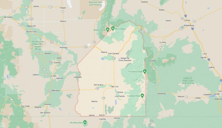
Cities and Towns in Costilla County, Colorado
Founded on 1861-11-01, Costilla County is one of 64 counties in the state of Colorado. Historically, Costilla County was formed from Created as one of the 17 original counties of the Territory of Colorado. The city of San Luis is the county seat. With FIPS code of 23, Costilla County has a population of 3,625 and area of 1,229.38 square miles (3,184 km²).
List of all cities in Costilla County, CO alphabetically
City/Town | Postal Code | Area Code |
Blanca, CO | 81123 | 719 |
Chama, CO | 81126 | 719 |
El Rito, CO | 81152 | 719 |
Forbes Park, CO | 81133 | 719 |
Fort Garland, CO | 81133 | 719 |
Garcia, CO | 81152 | 719 |
Jaroso, CO | 81138 | 719 |
Los Fuertes, CO | 81152 | 719 |
Mesita, CO | 81152 | 719 |
San Francisco, CO | 81152 | 719 |
San Luis, CO | 81152 | 719 |
San Pablo, CO | 81152 | 719 |
San Pedro, CO | 81152 | 719 |
Sangre de Cri, CO | 81133 | 719 |
Sangre de Cristo Ranches, CO | 81133 | 719 |
Wildhorse Mesa, CO | 81152 | 719 |
Major Cities and Towns in Costilla County, Colorado
San Luis
Area, Population, Zip Codes, and Coordinates
- Area: 0.55 square miles
- Population: Approximately 630 (2023 estimate)
- Zip Codes: 81152
- Latitude and Longitude: 37.2006° N, 105.4247° W
Location and History
San Luis, the county seat of Costilla County, holds the distinction of being the oldest continuously inhabited town in Colorado, established in 1851. Located in the San Luis Valley, San Luis was founded by Hispanic settlers from New Mexico who were drawn to the fertile lands along the Culebra Creek. The town’s early history is deeply connected to the traditions and culture of its settlers, which is still evident today in the town’s architecture, festivals, and community life. San Luis served as a critical agricultural center for the region, with irrigation systems developed to support farming in the arid environment. The town is also known for the historic Land Grant system, under which land was distributed to settlers, a system that still influences local land ownership today.
Major Schools and Landmarks
San Luis is served by the Centennial School District R-1, with Centennial High School and Centennial Elementary School being the main educational institutions. Major landmarks include the Sangre de Cristo Catholic Church, a historic church that overlooks the town, and the Stations of the Cross Shrine, a popular pilgrimage site featuring life-sized bronze statues depicting the Passion of Christ. The town’s historic downtown includes the R&R Market, the oldest continuously operating business in Colorado. San Luis also hosts cultural events that celebrate its Hispanic heritage, such as the annual Fiesta de Santiago y Santa Ana. The town’s deep historical roots and cultural significance make it a vital part of Colorado’s heritage.
Fort Garland
Area, Population, Zip Codes, and Coordinates
- Area: 0.23 square miles
- Population: Approximately 400 (2023 estimate)
- Zip Codes: 81133
- Latitude and Longitude: 37.4247° N, 105.4344° W
Location and History
Fort Garland is a small town located in the eastern part of Costilla County, near the Sangre de Cristo Mountains. The town grew around the historic Fort Garland, which was established in 1858 to protect settlers in the San Luis Valley from Native American raids. The fort played a significant role in the military history of the region, with notable figures such as Kit Carson serving there. After the fort was decommissioned in 1883, the town of Fort Garland developed as a residential community. Today, Fort Garland is known for its rich history, with the original fort preserved as a museum that tells the story of the early military presence in Colorado and the interactions between settlers and Native Americans.
Major Schools and Landmarks
Fort Garland is part of the Sierra Grande School District, with students typically attending Sierra Grande School in nearby Blanca. The primary landmark in Fort Garland is the Fort Garland Museum and Cultural Center, which includes several original buildings from the 19th century and exhibits on the fort’s history and the region’s early settlers. The town is also close to the Great Sand Dunes National Park and Preserve, offering stunning natural landscapes and outdoor recreation opportunities. Fort Garland’s historical significance and proximity to natural attractions make it a small but important community in Costilla County.
Blanca
Area, Population, Zip Codes, and Coordinates
- Area: 0.21 square miles
- Population: Approximately 400 (2023 estimate)
- Zip Codes: 81123
- Latitude and Longitude: 37.4386° N, 105.5114° W
Location and History
Blanca is a small town located in the northern part of Costilla County, just west of Fort Garland. The town was founded in 1909 as a railroad stop along the Denver and Rio Grande Western Railroad. Blanca was named after the nearby Blanca Peak, one of Colorado’s highest mountains, which dominates the skyline and is a sacred site to the local Native American tribes. The town developed as an agricultural community, with farming and ranching as the primary economic activities. Blanca’s location near the base of the Sangre de Cristo Mountains provides it with stunning views and access to outdoor recreation, making it a desirable location for those seeking a rural lifestyle in a beautiful natural setting.
Major Schools and Landmarks
Blanca is served by the Sierra Grande School District, with Sierra Grande School providing education from kindergarten through 12th grade. Major landmarks in Blanca include the historic Denver and Rio Grande Railroad Depot, which reflects the town’s origins as a railroad community, and Blanca Peak, which offers hiking and climbing opportunities for outdoor enthusiasts. The town is also near the Zapata Falls, a popular natural attraction featuring a stunning waterfall hidden in a rocky crevasse. Blanca’s small-town charm, historical significance, and proximity to the mountains make it a unique and welcoming community in Costilla County.
Chama
Area, Population, Zip Codes, and Coordinates
- Area: N/A (unincorporated community)
- Population: Approximately 120 (2023 estimate)
- Zip Codes: 81126
- Latitude and Longitude: 37.1514° N, 105.5483° W
Location and History
Chama is a small, unincorporated community located in the southern part of Costilla County, near the New Mexico border. The community was established in the late 19th century as a farming and ranching settlement. Chama’s history is closely tied to the Hispanic settlers who migrated north from New Mexico, bringing with them a rich cultural heritage that still influences the area today. The community has remained small and rural, with agriculture continuing to be the mainstay of the local economy. Chama is known for its quiet, pastoral landscape and its close-knit community, where traditions and a slower pace of life are valued.
Major Schools and Landmarks
Chama is part of the Centennial School District R-1, with students attending schools in nearby San Luis. Landmarks in and around Chama include the Culebra Range, part of the Sangre de Cristo Mountains, which provides opportunities for hiking and wildlife viewing. The area is also known for its historic adobe homes and churches, which reflect the architectural style brought by the early Hispanic settlers. Chama’s rural location and strong cultural ties make it a unique community within Costilla County, offering a glimpse into the traditional agricultural lifestyle that has shaped the region for generations.
San Acacio
Area, Population, Zip Codes, and Coordinates
- Area: N/A (unincorporated community)
- Population: Approximately 50 (2023 estimate)
- Zip Codes: 81151
- Latitude and Longitude: 37.2353° N, 105.5878° W
Location and History
San Acacio is a small, unincorporated community located in the southern part of Costilla County. The town was founded in the mid-19th century by Hispanic settlers, making it one of the oldest communities in Colorado. San Acacio is named after Saint Acacius, reflecting the strong Catholic heritage of the settlers who established the town. The community grew as an agricultural settlement, with farming and ranching as the primary economic activities. Over the years, San Acacio has remained a small, rural community, deeply connected to its cultural and historical roots. The town’s adobe structures and historic church stand as testaments to its long history and the endurance of its traditional way of life.
Major Schools and Landmarks
San Acacio is served by the Centennial School District R-1, with students attending schools in nearby San Luis. Major landmarks in San Acacio include the San Acacio Mission Church, one of the oldest churches in Colorado, built in the 1850s. The church is a significant cultural and historical site, reflecting the deep faith and traditions of the community’s founders. The surrounding landscape, with its open fields and views of the Sangre de Cristo Mountains, offers a serene and picturesque setting. San Acacio’s small size, historic significance, and cultural heritage make it a unique and important part of Costilla County’s history.