Cities and Towns in Clear Creek County, Colorado

Founded on 1861-11-01, Clear Creek County is one of 64 counties in the state of Colorado. Historically, Clear Creek County was formed from Created as one of the 17 original counties of the Territory of Colorado. The city of Georgetown is the county seat. With FIPS code of 19, Clear Creek County has a population of 9,446 and area of 396.53 square miles (1,027 km²).

List of all cities in Clear Creek County, CO alphabetically

City/Town Postal Code Area Code
Dumont, CO 80436 303/720
Empire, CO 80438 303/720
Georgetown, CO 80444 303/720
Idaho Springs, CO 80452 303/720
Silver Plume, CO 80476 303/720

Major Cities and Towns in Clear Creek County, Colorado

Idaho Springs

Area, Population, Zip Codes, and Coordinates

  • Area: 2.2 square miles
  • Population: Approximately 1,800 (2023 estimate)
  • Zip Codes: 80452
  • Latitude and Longitude: 39.7425° N, 105.5142° W

Location and History

Idaho Springs, the largest town in Clear Creek County, is nestled in the Rocky Mountains just 30 miles west of Denver. The town was founded in 1859 during the Colorado Gold Rush when prospectors discovered gold in Clear Creek. Idaho Springs quickly became a bustling mining town, and it is one of the few towns in Colorado where gold is still actively mined. The town was named after the hot springs that flow through the area, which have been used for their therapeutic properties since the days of the Ute Indians. Over time, Idaho Springs evolved from a mining hub into a popular tourist destination, offering a mix of historic charm and outdoor recreation opportunities. The town’s preserved 19th-century architecture and vibrant Main Street draw visitors year-round.

Major Schools and Landmarks

Idaho Springs is served by the Clear Creek School District RE-1, with Clear Creek High School and Carlson Elementary School providing education to local students. Significant landmarks include the Argo Gold Mine and Mill, a National Historic Landmark that offers tours and gold panning experiences, and the Indian Hot Springs, where visitors can soak in natural hot springs surrounded by a tropical greenhouse. The nearby Mount Evans Scenic Byway, the highest paved road in North America, provides breathtaking views and access to the summit of Mount Evans. Idaho Springs also serves as a gateway to outdoor adventures, including hiking, white-water rafting, and skiing, making it a vibrant community with deep historical roots.

Georgetown

Area, Population, Zip Codes, and Coordinates

  • Area: 1.1 square miles
  • Population: Approximately 1,100 (2023 estimate)
  • Zip Codes: 80444
  • Latitude and Longitude: 39.7061° N, 105.6972° W

Location and History

Georgetown, often referred to as the “Silver Queen of the Rockies,” is a historic town located in the Clear Creek Valley, about 45 miles west of Denver. Founded in 1859, Georgetown quickly became a major silver mining center, attracting thousands of prospectors during the Colorado Silver Boom. The town was named after George Griffith, one of its early settlers. Georgetown’s prosperity during the late 19th century is reflected in its well-preserved Victorian architecture, which has earned it a place on the National Register of Historic Places. Today, Georgetown is a popular tourist destination, known for its rich history, scenic beauty, and easy access to outdoor activities in the surrounding mountains.

Major Schools and Landmarks

Georgetown is part of the Clear Creek School District RE-1, with students attending schools in nearby towns such as Idaho Springs. Major landmarks include the Georgetown Loop Railroad, a historic narrow-gauge railroad that offers scenic rides through the Rocky Mountains, and the Hotel de Paris Museum, a beautifully preserved 19th-century hotel that provides insights into the town’s history. The town’s historic district features a collection of Victorian-era buildings, including the Georgetown Energy Museum and the Hamill House Museum. Georgetown Lake, located just outside the town, is a popular spot for fishing and picnicking. The town also hosts several events throughout the year, including the Christmas Market, which draws visitors from across the region.

Silver Plume

Area, Population, Zip Codes, and Coordinates

  • Area: 0.3 square miles
  • Population: Approximately 170 (2023 estimate)
  • Zip Codes: 80476
  • Latitude and Longitude: 39.6975° N, 105.7258° W

Location and History

Silver Plume is a small, historic town located just west of Georgetown along Interstate 70 in Clear Creek County. The town was established in 1869 during the Colorado Silver Boom and quickly became a significant silver mining community. Silver Plume’s name is said to have been inspired by a line from a poem about the discovery of a silver plume. The town grew rapidly in the late 19th century, with mining activities driving its economy. However, like many mining towns, Silver Plume’s fortunes declined as the silver mines were exhausted. Today, the town is known for its well-preserved historic buildings and its scenic setting in the Rocky Mountains, offering a glimpse into Colorado’s mining past.

Major Schools and Landmarks

Silver Plume is served by the Clear Creek School District RE-1, with students typically attending schools in nearby Georgetown or Idaho Springs. Key landmarks in Silver Plume include the historic Silver Plume Depot, part of the Georgetown Loop Railroad, which connects the town to Georgetown and offers a scenic journey through the mountains. The town also features several historic homes and buildings from the mining era, many of which have been restored and are now part of the Silver Plume Historic District, a designated National Historic Landmark. The nearby hiking trails, such as the 7:30 Mine Trail, provide outdoor enthusiasts with opportunities to explore the mountains and enjoy panoramic views of the surrounding landscape.

Empire

Area, Population, Zip Codes, and Coordinates

  • Area: 0.3 square miles
  • Population: Approximately 300 (2023 estimate)
  • Zip Codes: 80438
  • Latitude and Longitude: 39.7614° N, 105.6828° W

Location and History

Empire is a small town located in Clear Creek County, about 40 miles west of Denver on U.S. Highway 40. The town was founded in the early 1860s as a result of the Colorado Gold Rush and quickly developed as a center for gold and silver mining. Empire was named after the state of New York, known as the Empire State, reflecting the hopes of its founders for prosperity. The town served as a gateway to the mining camps in the surrounding mountains, and its economy thrived during the mining boom. Although the mining industry declined in the early 20th century, Empire remained a vital stop for travelers heading to the mountain resorts and outdoor recreation areas in the Rockies.

Major Schools and Landmarks

Empire is part of the Clear Creek School District RE-1, with students attending schools in nearby towns such as Georgetown and Idaho Springs. Significant landmarks in Empire include the Hard Rock Cafe, a historic building that now serves as a restaurant and community gathering place, and the Peck House, one of Colorado’s oldest hotels, which has been in operation since 1862. The town is also close to the Empire Pass, a scenic mountain pass that offers access to hiking, skiing, and other outdoor activities. Empire’s rich history and proximity to recreational opportunities make it a charming and historically significant town in Clear Creek County.

Dumont

Area, Population, Zip Codes, and Coordinates

  • Area: N/A (unincorporated community)
  • Population: Approximately 400 (2023 estimate)
  • Zip Codes: 80436
  • Latitude and Longitude: 39.7642° N, 105.6003° W

Location and History

Dumont is a small, unincorporated community located along Clear Creek in Clear Creek County, just off Interstate 70. The community was established in the late 19th century as a stop along the Colorado Central Railroad, which connected the mining towns in the mountains to Denver. Dumont was named after John M. Dumont, a prominent railroad official. The town developed primarily as a residential area for workers involved in the mining industry and the railroad. Although Dumont never grew as large as some of the nearby mining towns, it has remained a small but vibrant community with a rich history tied to Colorado’s early railroad and mining industries.

Major Schools and Landmarks

Dumont is served by the Clear Creek School District RE-1, with students typically attending schools in nearby Idaho Springs. The community’s landmarks include historic buildings and homes that reflect its railroad and mining heritage. The nearby Clear Creek offers opportunities for fishing, rafting, and other outdoor activities, making Dumont a popular spot for residents and visitors seeking a quiet, scenic retreat. The town is also close to the Loveland Ski Area, one of Colorado’s premier ski resorts, providing easy access to winter sports. Dumont’s small size and picturesque location make it a peaceful and charming community within Clear Creek County.

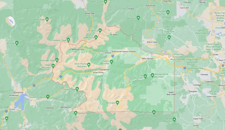
Map of Cities in Clear Creek County, CO

Map of Cities in Clear Creek County, CO