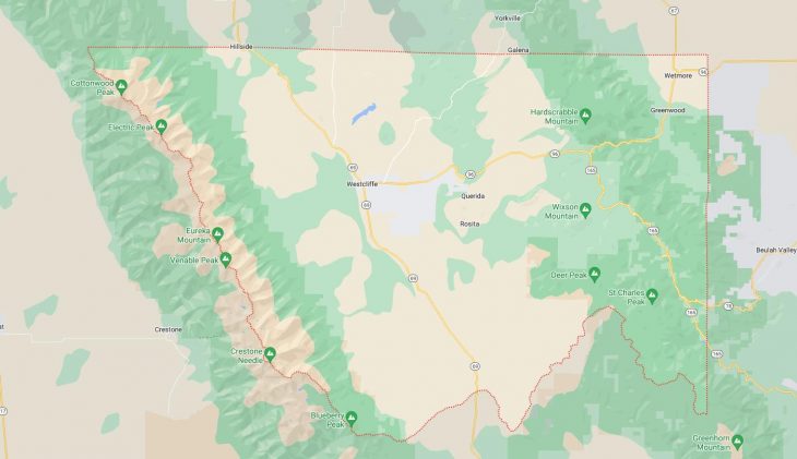
Cities and Towns in Custer County, Colorado

Founded on 1877-03-09, Custer County is one of 64 counties in the state of Colorado. Historically, Custer County was split from Fremont County. The city of Westcliffe is the county seat. With FIPS code of 27, Custer County has a population of 5,045 and area of 739.24 square miles (1,915 km²).

List of all cities in Custer County, CO alphabetically

City/Town Postal Code Area Code
Greenwood, CO 81253 719
Horn Creek, CO 81252 719
Rosita, CO 81252 719
Silver Cliff, CO 81252 719
Tanglewood Acres, CO 81252 719
Westcliffe, CO 81252 719
Wetmore, CO 81253 719

Major Cities and Towns in Custer County, Colorado

Westcliffe

Area, Population, Zip Codes, and Coordinates

  • Area: 1.2 square miles
  • Population: Approximately 600 (2023 estimate)
  • Zip Codes: 81252
  • Latitude and Longitude: 38.1344° N, 105.4653° W

Location and History

Westcliffe is the county seat and the largest town in Custer County, nestled in the Wet Mountain Valley at the base of the Sangre de Cristo Mountains. The town was founded in 1887 as a hub for ranching and agriculture, and it quickly became a central point for the transportation of goods and livestock due to the arrival of the Denver and Rio Grande Railroad. Westcliffe’s location, with its stunning views of the nearby mountain ranges, made it an attractive spot for settlers. Over the years, the town has maintained its rural charm and historic character, with many of the original buildings still in use. Today, Westcliffe is known for its outdoor recreational opportunities, including hiking, horseback riding, and stargazing, as it is one of the few designated International Dark Sky Communities.

Major Schools and Landmarks

Westcliffe is served by the Custer County School District, with Custer County High School and Custer County Elementary School providing education to the local community. Major landmarks include the historic Beckwith Ranch, a restored late-19th-century cattle ranch that offers a glimpse into the region’s ranching heritage. The town is also a gateway to the Sangre de Cristo Wilderness, which offers numerous trails leading to high alpine lakes and mountain peaks. Westcliffe’s Smokey Jack Observatory is a notable attraction for stargazers, taking advantage of the area’s pristine night skies. The annual High Mountain Hay Fever Bluegrass Festival is another highlight, attracting music lovers from across the country.

Silver Cliff

Area, Population, Zip Codes, and Coordinates

  • Area: 15.1 square miles
  • Population: Approximately 600 (2023 estimate)
  • Zip Codes: 81252
  • Latitude and Longitude: 38.1358° N, 105.4439° W

Location and History

Silver Cliff, located adjacent to Westcliffe, shares much of its history and heritage. The town was founded in 1879 during the Colorado Silver Boom and quickly grew into one of the state’s largest towns due to the discovery of rich silver deposits in the area. At its peak, Silver Cliff was a bustling mining town with a population in the thousands. However, as the silver mines played out, the town’s population dwindled, and it eventually became a quieter, rural community. Today, Silver Cliff retains its historical significance, with many of the original buildings and mine structures still visible, reflecting the town’s rich mining heritage.

Major Schools and Landmarks

Silver Cliff is also served by the Custer County School District, with students attending schools in nearby Westcliffe. Major landmarks in Silver Cliff include the old mining sites and the historic Silver Cliff Cemetery, which offers panoramic views of the surrounding mountains and serves as a reminder of the town’s past. The town is also close to the Wet Mountain Valley, a beautiful area known for its ranches, open spaces, and views of the Sangre de Cristo Mountains. Silver Cliff, like Westcliffe, benefits from its location within the International Dark Sky Community, making it an excellent spot for stargazing and enjoying the natural beauty of the Colorado night skies.

Wetmore

Area, Population, Zip Codes, and Coordinates

  • Area: N/A (unincorporated community)
  • Population: Approximately 500 (2023 estimate)
  • Zip Codes: 81253
  • Latitude and Longitude: 38.2397° N, 105.0847° W

Location and History

Wetmore is a small, unincorporated community located in the northeastern part of Custer County, near the Wet Mountains. The community was established in the late 19th century, originally serving as a ranching and farming area. Wetmore’s location along the junction of State Highway 96 and State Highway 67 made it an important crossroads for travelers and traders in the region. The town has remained relatively small and rural, with its residents enjoying a quiet, peaceful lifestyle surrounded by the natural beauty of the Wet Mountains. Wetmore’s proximity to larger towns like Florence and Cañon City provides access to additional amenities while allowing it to maintain its rural character.

Major Schools and Landmarks

Wetmore is part of the Custer County School District, with students typically attending schools in Westcliffe or nearby communities. The area around Wetmore is known for its natural beauty, with landmarks such as the San Isabel National Forest offering opportunities for hiking, camping, and wildlife viewing. The town is also near Lake Isabel, a popular destination for fishing, boating, and picnicking. Wetmore’s location at the edge of the Wet Mountains provides stunning views and easy access to outdoor recreation, making it a favorite spot for those who appreciate Colorado’s rugged landscapes. Despite its small size, Wetmore’s scenic surroundings and historical roots make it a unique and tranquil community within Custer County.

Map of Cities in Custer County, CO

Map of Cities in Custer County, CO