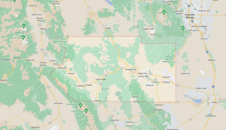
Cities and Towns in Fremont County, Colorado
Founded on 1861-11-01, Fremont County is one of 64 counties in the state of Colorado. Historically, Fremont County was formed from Created as one of the 17 original counties of the Territory of Colorado. The city of Cañon City is the county seat. With FIPS code of 43, Fremont County has a population of 49,661 and area of 1,533.09 square miles (3,971 km²).
List of all cities in Fremont County, CO alphabetically
City/Town | Postal Code | Area Code |
Brewster, CO | 81226 | 719 |
Buckskin Joe, CO | 81212 | 719 |
Canon City, CO | 81212 | 719 |
81215 | 719 | |
Coal Creek, CO | 81221 | 719 |
Coaldale, CO | 81222 | 719 |
Cotopaxi, CO | 81223 | 719 |
Federal Correctional Complex, CO | 81290 | 719 |
Florence, CO | 81226 | 719 |
81290 | 719 | |
Hillside, CO | 81232 | 719 |
Howard, CO | 81233 | 719 |
Ilse, CO | 81212 | 719 |
Parkdale, CO | 81212 | 719 |
Penitentiary, CO | 81212 | 719 |
Penrose, CO | 81240 | 719 |
Portland, CO | 81226 | 719 |
Prospect Heights, CO | 81212 | 719 |
Rockvale, CO | 81244 | 719 |
Texas Creek, CO | 81223 | 719 |
Williamsburg, CO | 81226 | 719 |
Major Cities and Towns in Fremont County, Colorado
Cañon City
Area, Population, Zip Codes, and Coordinates
- Area: 12.5 square miles
- Population: Approximately 17,000 (2023 estimate)
- Zip Codes: 81212, 81215
- Latitude and Longitude: 38.4404° N, 105.2424° W
Location and History
Cañon City, the county seat of Fremont County, is located in the Arkansas River Valley at the edge of the Rocky Mountains. Founded in 1858, it is one of Colorado’s oldest cities, originally established as a supply town for nearby mining camps. The city’s name, which means “canyon” in Spanish, reflects its proximity to the Royal Gorge, a deep canyon carved by the Arkansas River. Cañon City’s growth was spurred by the arrival of the Denver & Rio Grande Railroad in the late 19th century, which made it a key transportation hub. Today, Cañon City is known for its historic downtown, outdoor recreational opportunities, and as the location of several state and federal correctional facilities, earning it the nickname “Prison Capital of Colorado.”
Major Schools and Landmarks
Cañon City is served by the Cañon City School District Fremont RE-1, with Cañon City High School and Harrison School being major educational institutions. Major landmarks include the Royal Gorge Bridge and Park, home to one of the world’s highest suspension bridges, offering breathtaking views and various attractions. The city also features the Royal Gorge Route Railroad, a popular tourist train that travels through the stunning Royal Gorge. The Museum of Colorado Prisons, housed in a former women’s prison, provides a unique glimpse into the state’s correctional history. Additionally, the Arkansas River is a focal point for outdoor activities such as white-water rafting, fishing, and hiking.
Florence
Area, Population, Zip Codes, and Coordinates
- Area: 4.1 square miles
- Population: Approximately 3,900 (2023 estimate)
- Zip Codes: 81226, 81290
- Latitude and Longitude: 38.3900° N, 105.1183° W
Location and History
Florence is a small town located southeast of Cañon City in Fremont County. It was founded in 1873 and named after the daughter of one of the town’s founders, James McCandless. Florence quickly became a center for the oil industry in Colorado, home to the first commercial oil field west of the Mississippi River. The discovery of oil in the nearby Florence Oil Field in the 1860s led to the establishment of numerous refineries, which drove the town’s growth and prosperity. Over time, Florence also developed a strong agricultural base, with its economy now diversified into tourism, antiques, and art galleries, making it a charming and culturally rich community.
Major Schools and Landmarks
Florence is served by the Fremont RE-2 School District, with Florence Junior/Senior High School being the main educational institution. Significant landmarks include the Florence Pioneer Museum, which chronicles the town’s rich history, and the Florence Historic District, which features well-preserved buildings from the late 19th and early 20th centuries. The town is also known for its vibrant arts scene, with numerous galleries and shops along Main Street. Nearby, the Garden Park Fossil Area is an important paleontological site where some of the first dinosaur fossils in the United States were discovered, adding to Florence’s historical significance.
Penrose
Area, Population, Zip Codes, and Coordinates
- Area: 11.3 square miles
- Population: Approximately 3,600 (2023 estimate)
- Zip Codes: 81240
- Latitude and Longitude: 38.4258° N, 105.0239° W
Location and History
Penrose is an unincorporated community located northeast of Cañon City, nestled between the Arkansas River and the Wet Mountains. The town was established in the early 1900s by Spencer Penrose, a prominent entrepreneur, who envisioned it as an agricultural colony. Penrose’s development was driven by the construction of the Beaver Park Dam, which provided irrigation for orchards and farms, helping the community thrive as a center for fruit growing and agriculture. Although the agricultural industry has changed over the years, Penrose remains a rural community with a strong sense of local identity, offering a peaceful lifestyle close to the larger cities of Cañon City and Pueblo.
Major Schools and Landmarks
Penrose is served by the Fremont RE-2 School District, with Penrose Elementary School being the primary educational facility. Major landmarks in Penrose include the Beaver Creek State Wildlife Area, which offers outdoor recreation opportunities such as hunting, fishing, and hiking. The town is also home to the Penrose Heritage Museum, which showcases local history and artifacts from the area’s early settlers. The annual Apple Day Festival celebrates the town’s agricultural heritage, highlighting Penrose’s historical roots in fruit growing and community farming. The scenic roads and trails around Penrose make it a popular spot for biking, horseback riding, and enjoying the natural beauty of the region.
Coal Creek
Area, Population, Zip Codes, and Coordinates
- Area: 1.0 square mile
- Population: Approximately 350 (2023 estimate)
- Zip Codes: 81221
- Latitude and Longitude: 38.3711° N, 105.1478° W
Location and History
Coal Creek is a small town located south of Florence in Fremont County. The town was established in the late 19th century as a coal mining community, named after the abundant coal deposits in the area. Coal Creek’s history is closely tied to the mining industry, which provided the primary source of employment and economic activity for much of its early years. The town grew rapidly during the coal boom, attracting miners and their families. However, as the demand for coal decreased and mining operations ceased, Coal Creek transitioned into a quiet residential community. Today, Coal Creek retains its small-town charm and serves as a peaceful place to live, with many residents commuting to nearby towns for work.
Major Schools and Landmarks
Coal Creek is part of the Fremont RE-2 School District, with students typically attending schools in nearby Florence. The town’s primary landmarks include remnants of its mining past, such as old mine entrances and structures that can be found in the surrounding hills. Coal Creek is also close to the historic Florence and Cripple Creek Railroad, which once played a crucial role in transporting coal and other goods through the region. The town’s proximity to the Arkansas River and various state parks provides residents with ample opportunities for outdoor activities such as fishing, hiking, and wildlife viewing, contributing to the area’s quiet, rural lifestyle.
Brookside
Area, Population, Zip Codes, and Coordinates
- Area: 0.4 square miles
- Population: Approximately 250 (2023 estimate)
- Zip Codes: 81212
- Latitude and Longitude: 38.4139° N, 105.2100° W
Location and History
Brookside is a small town located just southeast of Cañon City in Fremont County. The town was established in the early 1900s as a residential community for workers in the nearby coal mines and railroads. Brookside’s name reflects its location near the banks of several small streams or brooks that run through the area. Although it was initially a mining town, Brookside evolved into a residential community with a focus on family life and local amenities. The town has retained its small-town character over the years, offering a quiet and close-knit environment for its residents.
Major Schools and Landmarks
Brookside is served by the Cañon City School District Fremont RE-1, with students attending schools in nearby Cañon City. Notable landmarks include Brookside Park, which provides recreational facilities and a community gathering space for local events. The town’s proximity to Cañon City allows residents easy access to the larger city’s amenities and attractions, such as the Royal Gorge Bridge and the Arkansas River. Brookside’s historical connection to the mining industry is still evident in some of the older buildings and homes that date back to the early 20th century, contributing to the town’s nostalgic and historical ambiance.