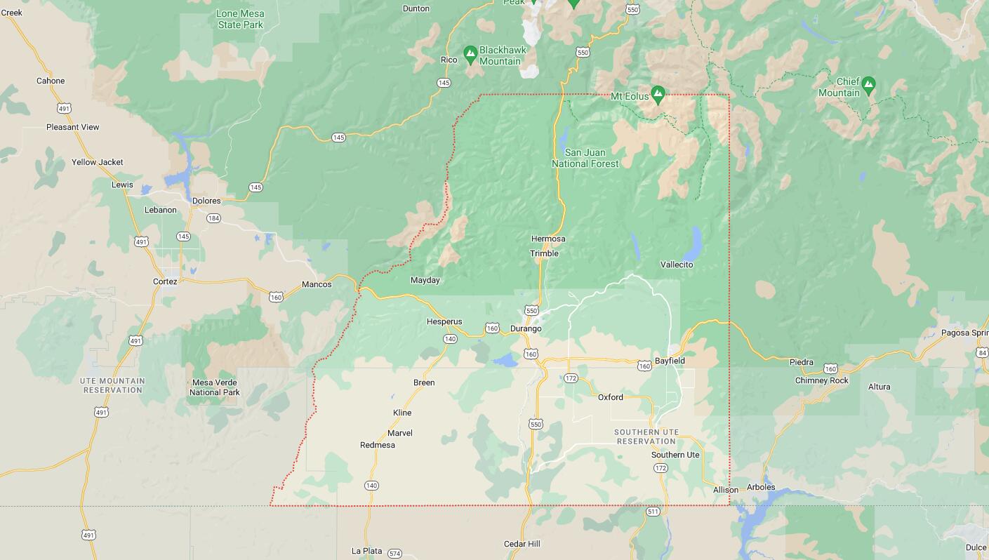
Cities and Towns in La Plata County, Colorado
Founded on 1874-02-10, La Plata County is one of 64 counties in the state of Colorado. Historically, La Plata County was split from Lake and Conejos counties. The city of Durango is the county seat. With FIPS code of 67, La Plata County has a population of 56,250 and area of 1,700.44 square miles (4,404 km²).
List of all cities in La Plata County, CO alphabetically
| City/Town | Postal Code | Area Code |
| Buena Vista, CO | 81251 | 719 |
| Climax, CO | 80429 | 719 |
| Leadville, CO | 80429 | 719 |
| 80461 | 719 | |
| Twin Lakes, CO | 81251 | 719 |
Major Cities and Towns in La Plata County, Colorado
Durango
Area, Population, and Geography
- Area: 13.9 square miles
- Population: Approximately 19,000 (2023 estimate)
- Zip Codes: 81301, 81302, 81303
- Latitude: 37.2753° N
- Longitude: 107.8801° W
City Location and History
Durango is the county seat and largest city in La Plata County, located in southwestern Colorado along the Animas River. Founded in 1880 by the Denver & Rio Grande Railroad, Durango quickly grew into a vital hub for mining and transportation in the region. The town’s name was inspired by Durango, Mexico, reflecting the influence of Spanish culture in the area. Durango’s economy historically centered on silver and gold mining, with the town serving as a supply center for nearby mining camps. The construction of the Durango & Silverton Narrow Gauge Railroad, which connected Durango to the mining town of Silverton, further boosted its development. Today, Durango is known for its well-preserved historic downtown, outdoor recreation opportunities, and vibrant cultural scene, attracting visitors from around the world.
Major Schools and Landmarks
Durango is served by the Durango School District 9-R, with Durango High School being the primary secondary institution. The city is also home to Fort Lewis College, a public liberal arts college offering a range of undergraduate programs. Major landmarks include the Durango & Silverton Narrow Gauge Railroad, which still operates as a tourist attraction, offering scenic train rides through the San Juan Mountains. The Animas River Trail provides a picturesque pathway for walking, biking, and enjoying the natural beauty of the area. The historic Strater Hotel, built in 1887, is another key landmark, reflecting Durango’s Victorian heritage. Durango Mountain Resort (Purgatory) offers skiing, snowboarding, and other winter sports just a short drive from the city. Durango’s combination of historical significance, educational resources, and outdoor activities makes it the cultural and economic heart of La Plata County.
Bayfield
Area, Population, and Geography
- Area: 1.6 square miles
- Population: Approximately 2,700 (2023 estimate)
- Zip Codes: 81122
- Latitude: 37.2253° N
- Longitude: 107.5995° W
City Location and History
Bayfield is a small town located in the eastern part of La Plata County, about 20 miles east of Durango. The town was established in 1898 and named after W.A. Bay, a prominent early settler and businessman. Bayfield developed as an agricultural community, with its economy primarily based on farming, ranching, and timber. The town’s location along the Los Pinos River provided a reliable water source for irrigation, helping to sustain the local agricultural industry. Over the years, Bayfield has maintained its small-town charm and rural character, while also experiencing growth due to its proximity to Durango and the surrounding natural beauty of the San Juan National Forest.
Major Schools and Landmarks
Bayfield is served by the Bayfield School District 10 JT-R, with Bayfield High School being the main secondary institution. The town’s major landmarks include the Bayfield Heritage Museum, which preserves the history of the town and the surrounding area with exhibits on early settlers, agriculture, and local industries. The nearby Vallecito Lake, a popular destination for fishing, boating, and camping, offers stunning mountain views and a variety of outdoor activities. Bayfield’s annual events, such as the Bayfield Heritage Days and Sheep Trailing Festival, celebrate the town’s agricultural roots and community spirit with parades, live music, and traditional crafts. Bayfield’s combination of rural charm, educational resources, and access to outdoor recreation makes it a valued part of La Plata County.
Ignacio
Area, Population, and Geography
- Area: 0.3 square miles
- Population: Approximately 800 (2023 estimate)
- Zip Codes: 81137
- Latitude: 37.1156° N
- Longitude: 107.6364° W
City Location and History
Ignacio is a small town located in the southern part of La Plata County, within the Southern Ute Indian Reservation. The town was founded in 1905 and named after Chief Ignacio, a leader of the Southern Ute Tribe. Ignacio developed as a cultural and administrative center for the Southern Ute Indian Tribe, with its economy traditionally based on agriculture, ranching, and tribal enterprises. The town’s location near the Piedra and Los Pinos Rivers made it an ideal spot for farming and ranching. Today, Ignacio serves as a gateway to the Southern Ute culture, offering visitors a glimpse into the tribe’s rich history and traditions.
Major Schools and Landmarks
Ignacio is served by the Ignacio School District 11 JT, with Ignacio High School being the primary secondary institution. The town’s major landmarks include the Southern Ute Cultural Center and Museum, which offers exhibits on the history, culture, and heritage of the Southern Ute Tribe. The Sky Ute Casino Resort, owned and operated by the Southern Ute Indian Tribe, is a significant landmark and economic driver in the area, offering gaming, dining, and entertainment options. The town’s annual Southern Ute Fair and Powwow is a major event that celebrates the tribe’s traditions with dancing, drumming, and cultural displays. Ignacio’s combination of cultural significance, educational resources, and community events makes it an important town in La Plata County.
Vallecito (Unincorporated Community)
Area, Population, and Geography
- Area: Approximately 1.5 square miles
- Population: Approximately 450 (2023 estimate)
- Zip Codes: 81122
- Latitude: 37.4778° N
- Longitude: 107.5639° W
City Location and History
Vallecito is an unincorporated community located in the northeastern part of La Plata County, near the shores of Vallecito Lake. The area was originally settled in the late 19th century, with ranching and farming being the primary economic activities. Vallecito, which means “little valley” in Spanish, is named after the picturesque valley in which it is located. The construction of the Vallecito Dam in the 1930s created Vallecito Lake, which became a popular destination for recreation and tourism. Today, Vallecito is known for its stunning natural beauty and serves as a gateway to the San Juan National Forest and Weminuche Wilderness, offering a wide range of outdoor activities.
Major Schools and Landmarks
Vallecito is part of the Bayfield School District 10 JT-R, with students attending schools in nearby Bayfield. The community’s major landmarks include Vallecito Lake, which offers opportunities for fishing, boating, and camping, making it a popular spot for locals and visitors alike. The Vallecito Lake Chamber of Commerce organizes various events throughout the year, including fishing tournaments, music festivals, and community gatherings. The surrounding San Juan National Forest provides access to hiking trails, wildlife viewing, and scenic drives, making Vallecito a hub for outdoor enthusiasts. The nearby Weminuche Wilderness, the largest wilderness area in Colorado, offers more adventurous pursuits such as backpacking and mountaineering. Vallecito’s combination of natural beauty, recreational opportunities, and community spirit makes it a treasured part of La Plata County.
Map of Cities in La Plata County, CO